GSV: Geological Survey of Victoria   Geological Survey of Victoria

GBOC66A

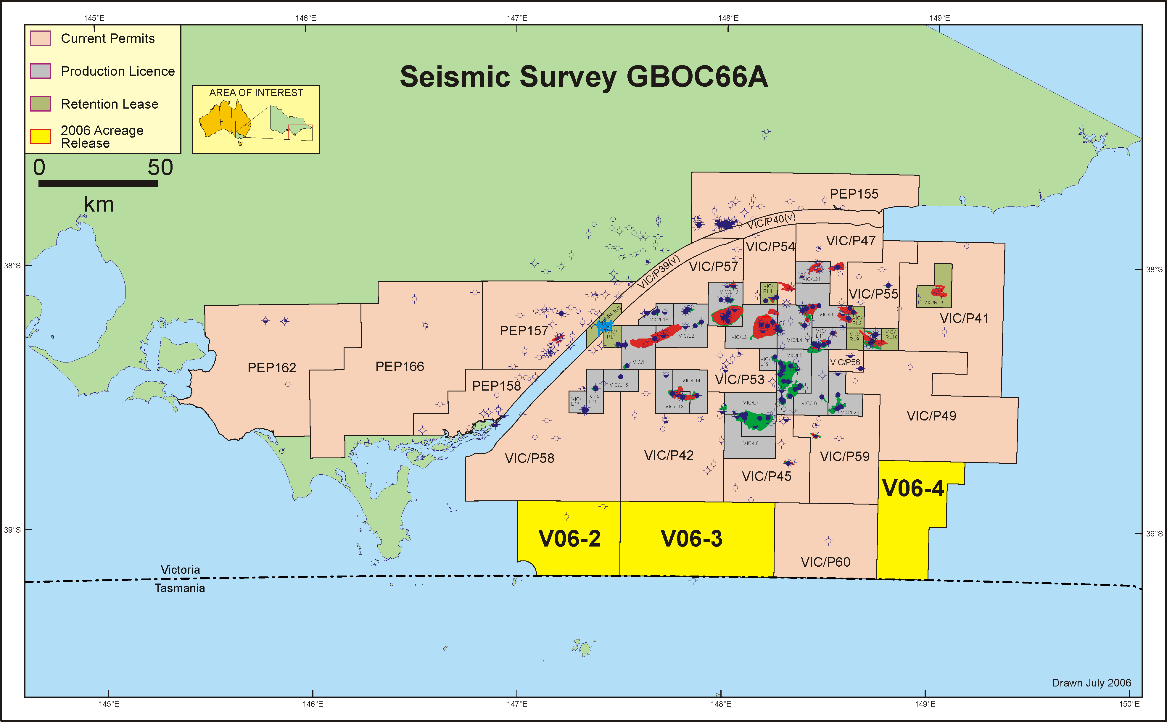
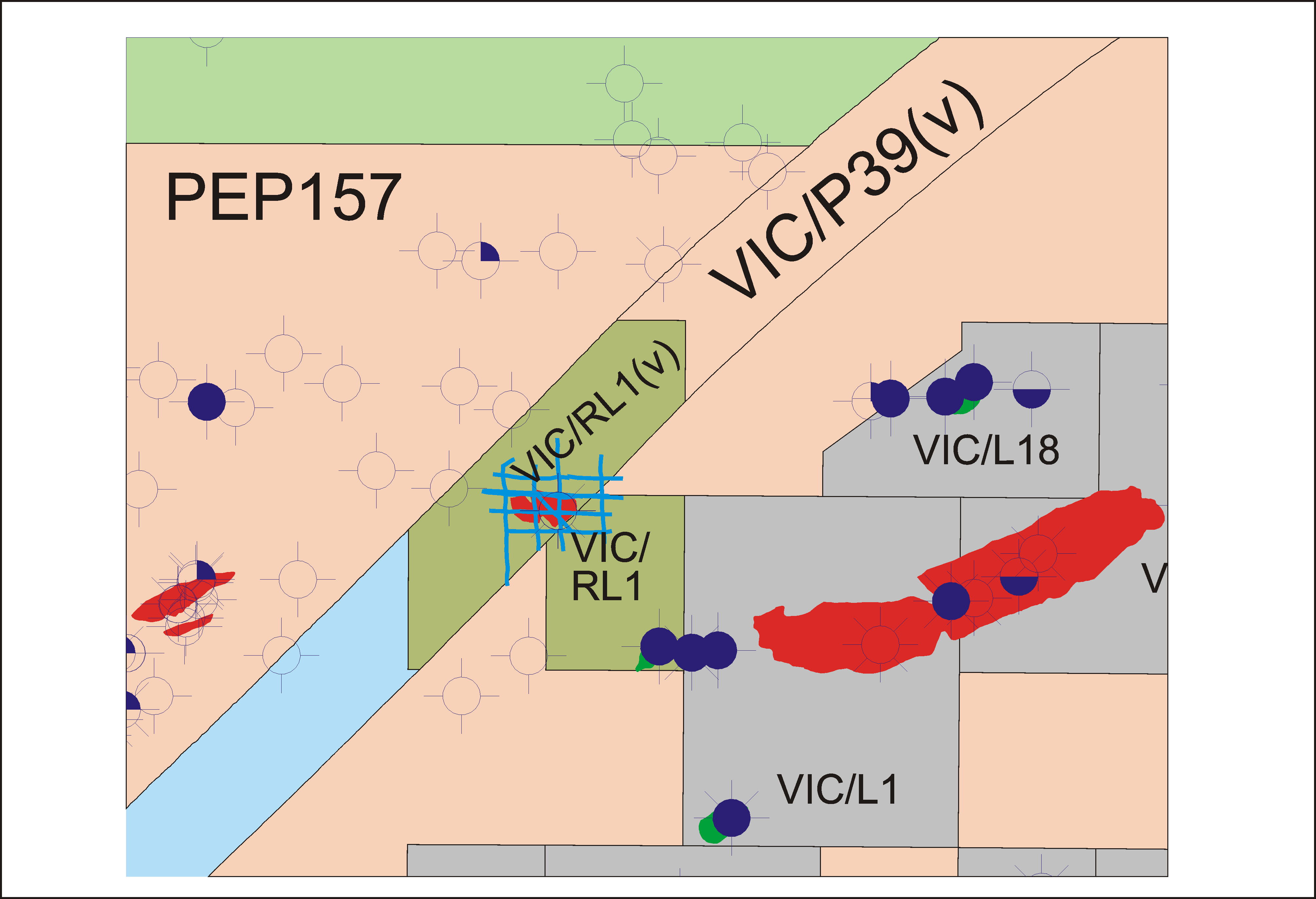
GDA94 shot point navigation data file (compressed) : ../peimages/gboc66a_gda94.asc.gz Polygon showing general outline area of 2D survey lines (compressed) : ../peimages/gboc66a_gda94_polygon_outline.asc.gz enlargement ../peimages/gboc66a_enlargement.pdf enlargement ../peimages/gboc66a_plus_enlargement.pdf PDF image file : ../peimages/gboc66a.pdf enlargement ../peimages/gboc66a_enlargement.png AGD66 shot point navigation data file (compressed) : ../peimages/gboc66a_agd66.asc.gz (Image) file: gboc66a.png


*** GBOC66A02 ***

gboc66a02 000 LINKS GIPPSLAND_ON_SHORE_SURVEYS GIPPSLAND_OFFSHORE_SURVEYS22-FEB-12 gboc66a02 000 LINKS GIPPSLAND_SURVEYS OTWAY_SURVEYS MURRAY_SURVEYS22-FEB-12 gboc66a02 000 LINKS HYPERLINKAGES ALL_SURVEYS ALL_WELLS ALL_ASSETS 22-FEB-12 gboc66a02 000 LINKS OTWAY_ON_SHORE_SURVEYS OTWAY_OFFSHORE_SURVEYS22-FEB-12
gboc66a02 001 LINE_HDR SEIS_LINE_NAME =GBOC66A-02
gboc66a02 002 LINE_HDR SEIS_SRVY_NAME =GBOC66A : FSP_NUM=1 LSP_NUM=34 LINE_LGTH=7.09
gboc66a02 003 LINE_HDR FSP_NUM =1 gboc66a02 003 LINE_HDR LINE_LGTH =7.09 gboc66a02 003 LINE_HDR LSP_NUM =34 gboc66a02 003 LINE_HDR SEIS_LINE_ID =200003168155 gboc66a02 003 LINE_HDR SEIS_LINE_NAME =GBOC66A-02 gboc66a02 003 LINE_HDR SOURCE =OPERATED gboc66a02 003 LINE_HDR TYPE =ACTUAL
gboc66a02 005 LINE_HDR COORD_SYSTEM_ID =4007 gboc66a02 005 LINE_HDR GEODETIC DATUM ID =4007 gboc66a02 005 LINE_HDR GEOD_DTM_QUALITY=KNOWN gboc66a02 005 LINE_HDR SPHEROID =CL58
gboc66a02 007 ASSETS ************ ASSETS FOR THIS LINE ONLY ********************** gboc66a02 007 ASSETS PE703181 HDR=SEISMIC SECTION [G063] Hydrosonde Record Line 2 [PAPER] 1966 PE703181__((_[G063]_HYDROSONDE_RECORD_LINE_2_))_.TIF(1.0m)......... gboc66a02 007 ASSETS PE703181.......................DESC=Hydrosonde Record Line 2, Golden Beach Area, by Wongela Geophysical Pty. Limited and Associates for Burmah Oil Co. of Australia Ltd., PEP42, G063. gboc66a02 007 ASSETS PE703181.......................LANC=GBOC66A-2 gboc66a02 007 ASSETS PE703182 HDR=SEISMIC SECTION [G063] Hydrosonde Record Line 2 [PAPER] 1966 PE703182__((_[G063]_HYDROSONDE_RECORD_LINE_2_))_.TIF(1.2m)......... gboc66a02 007 ASSETS PE703182.......................DESC=Hydrosonde Record Line 2, Golden Beach Area, by Wongela Geophysical Pty. Limited and Associates for Burmah Oil Co. of Australia Ltd., PEP42, G063. gboc66a02 007 ASSETS PE703182.......................LANC=GBOC66A-2
gboc66a02 009 ASSETS ***** (the above list for the line may not be as accurate compared to the survey list) ***** gboc66a02 009 ASSETS ***** PLEASE ALSO SEE THE SURVEY FOR ASSETS FOR THE WHOLE OF THIS SURVEY *****
gboc66a02 010 LINE_HDR SEIS_SRVY_NAME =GBOC66A
gboc66a02 302 SDO: CLOSE/INTERSECTING title polygons: TITLE_NAME=PEP42 gboc66a02 302 SDO: CLOSE/INTERSECTING title polygons: TITLE_NAME=VIC/P27 gboc66a02 302 SDO: CLOSE/INTERSECTING title polygons: TITLE_NAME=VIC/P27(V) gboc66a02 302 SDO: CLOSE/INTERSECTING title polygons: TITLE_NAME=VIC/P36 gboc66a02 302 SDO: CLOSE/INTERSECTING title polygons: TITLE_NAME=VIC/P58 gboc66a02 302 SDO: CLOSE/INTERSECTING title polygons: TITLE_NAME=VIC/P8 gboc66a02 302 SDO: CLOSE/INTERSECTING title polygons: TITLE_NAME=VIC/RL1(V) gboc66a02 302 SDO: INTERSECTING 2D LINES: SEIS_LINE_NAME=GA62-15 gboc66a02 302 SDO: INTERSECTING 2D LINES: SEIS_LINE_NAME=GA62-37 gboc66a02 302 SDO: INTERSECTING 2D LINES: SEIS_LINE_NAME=GBOC66A-06A gboc66a02 302 SDO: INTERSECTING 2D LINES: SEIS_LINE_NAME=GBOC66A-07 gboc66a02 302 SDO: INTERSECTING 2D LINES: SEIS_LINE_NAME=GBOC66A-07B gboc66a02 302 SDO: INTERSECTING 2D LINES: SEIS_LINE_NAME=GBOC66A-08A gboc66a02 302 SDO: INTERSECTING 2D LINES: SEIS_LINE_NAME=GBOC66A-09 gboc66a02 302 SDO: INTERSECTING 2D LINES: SEIS_LINE_NAME=GBOC67-40B gboc66a02 302 SDO: INTERSECTING 2D LINES: SEIS_LINE_NAME=GBOC67-41 gboc66a02 302 SDO: INTERSECTING 2D LINES: SEIS_LINE_NAME=GGSI85AE-02 gboc66a02 302 SDO: INTERSECTING 2D LINES: SEIS_LINE_NAME=GGSI85AE-03A gboc66a02 302 SDO: INTERSECTING 2D LINES: SEIS_LINE_NAME=GGSI85AE-13B
gboc66a02 899 HYPERLINKAGES COPYRIGHT_DISCLAIMER ABOUT_DBMAP HOW_TO_GET_OR_SUBMIT_DATA This data has been dumped from Victorian Govt (DPI: http://www.dpi.vic.gov.au) dbMap database on 22-FEB-12
gboc66a02 996 1 \ /\ /\ /\ /\ /\ /\ /\ / gboc66a02 996 2 \ / \ / \ / \ / \ / \ / \ / \ / gboc66a02 996 3 \ / \ / \ / \ / \ / \ / \ / \ / gboc66a02 996 4 \ / \ / \ / \ / \ / \ / \ / \ / gboc66a02 996 5 \ / \ / \ / \ / \ / \ / \ / \ / gboc66a02 996 6 \ / \ / \ / \ / \ / \ / \ / \ / gboc66a02 996 7 \/ \/ \/ \/ \/ \/ \/ \/ gboc66a02 996 8 gboc66a02 996 9


*** GBOC66A03 ***

gboc66a03 000 LINKS GIPPSLAND_ON_SHORE_SURVEYS GIPPSLAND_OFFSHORE_SURVEYS22-FEB-12 gboc66a03 000 LINKS GIPPSLAND_SURVEYS OTWAY_SURVEYS MURRAY_SURVEYS22-FEB-12 gboc66a03 000 LINKS HYPERLINKAGES ALL_SURVEYS ALL_WELLS ALL_ASSETS 22-FEB-12 gboc66a03 000 LINKS OTWAY_ON_SHORE_SURVEYS OTWAY_OFFSHORE_SURVEYS22-FEB-12
gboc66a03 001 LINE_HDR SEIS_LINE_NAME =GBOC66A-03
gboc66a03 002 LINE_HDR SEIS_SRVY_NAME =GBOC66A : FSP_NUM=1 LSP_NUM=13 LINE_LGTH=4.58
gboc66a03 003 LINE_HDR FSP_NUM =1 gboc66a03 003 LINE_HDR LINE_LGTH =4.58 gboc66a03 003 LINE_HDR LSP_NUM =13 gboc66a03 003 LINE_HDR SEIS_LINE_ID =200003168222 gboc66a03 003 LINE_HDR SEIS_LINE_NAME =GBOC66A-03 gboc66a03 003 LINE_HDR SOURCE =OPERATED gboc66a03 003 LINE_HDR TYPE =ACTUAL
gboc66a03 005 LINE_HDR COORD_SYSTEM_ID =4007 gboc66a03 005 LINE_HDR GEODETIC DATUM ID =4007 gboc66a03 005 LINE_HDR GEOD_DTM_QUALITY=KNOWN gboc66a03 005 LINE_HDR SPHEROID =CL58
gboc66a03 007 ASSETS ************ ASSETS FOR THIS LINE ONLY ********************** gboc66a03 007 ASSETS PE703170 HDR=SEISMIC SECTION [G063] Hydrosonde Record - Line 3 [PAPER] 1967 PE703170__((_[G063]_HYDROSONDE_RECORD_-_LINE_3_))_.TIF(0.3m)......... gboc66a03 007 ASSETS PE703170.......................DESC=Plate 12 Hydrosonde Record - Line 3, by Australian Hydrographic Services Pty. Ltd., for Burmah Oil Australia Ltd. Plate to accompany "G063 Golden Beach Seismic Survey Report" (PE702585). gboc66a03 007 ASSETS PE703170.......................LANC=GBOC66A-3 gboc66a03 007 ASSETS PE703175 HDR=SEISMIC SECTION [G063] Hydrosonde Record Line 3 [PAPER] 1967 PE703175__((_[G063]_HYDROSONDE_RECORD_LINE_3_))_.TIF(0.3m)......... gboc66a03 007 ASSETS PE703175.......................DESC=Hydrosonde Record Line 3, Golden Beach Area, by Wongela Geophysical Pty. Limited and Associates for Burmah Oil Co. of Australia Ltd., PEP42, G063. gboc66a03 007 ASSETS PE703175.......................LANC=GBOC66A-3
gboc66a03 009 ASSETS ***** (the above list for the line may not be as accurate compared to the survey list) ***** gboc66a03 009 ASSETS ***** PLEASE ALSO SEE THE SURVEY FOR ASSETS FOR THE WHOLE OF THIS SURVEY *****
gboc66a03 010 LINE_HDR SEIS_SRVY_NAME =GBOC66A
gboc66a03 302 SDO: CLOSE/INTERSECTING title polygons: TITLE_NAME=PEP42 gboc66a03 302 SDO: CLOSE/INTERSECTING title polygons: TITLE_NAME=VIC/P27(V) gboc66a03 302 SDO: CLOSE/INTERSECTING title polygons: TITLE_NAME=VIC/P36 gboc66a03 302 SDO: CLOSE/INTERSECTING title polygons: TITLE_NAME=VIC/P58 gboc66a03 302 SDO: CLOSE/INTERSECTING title polygons: TITLE_NAME=VIC/P8 gboc66a03 302 SDO: CLOSE/INTERSECTING title polygons: TITLE_NAME=VIC/RL1(V) gboc66a03 302 SDO: INTERSECTING 2D LINES: SEIS_LINE_NAME=G80A-4128 gboc66a03 302 SDO: INTERSECTING 2D LINES: SEIS_LINE_NAME=G88A-9019 gboc66a03 302 SDO: INTERSECTING 2D LINES: SEIS_LINE_NAME=G88A-9037 gboc66a03 302 SDO: INTERSECTING 2D LINES: SEIS_LINE_NAME=GA62-36 gboc66a03 302 SDO: INTERSECTING 2D LINES: SEIS_LINE_NAME=GA62-37 gboc66a03 302 SDO: INTERSECTING 2D LINES: SEIS_LINE_NAME=GBOC66A-06A gboc66a03 302 SDO: INTERSECTING 2D LINES: SEIS_LINE_NAME=GBOC66A-07 gboc66a03 302 SDO: INTERSECTING 2D LINES: SEIS_LINE_NAME=GBOC66A-07B gboc66a03 302 SDO: INTERSECTING 2D LINES: SEIS_LINE_NAME=GBOC66A-08A gboc66a03 302 SDO: INTERSECTING 2D LINES: SEIS_LINE_NAME=GBOC66A-09 gboc66a03 302 SDO: INTERSECTING 2D LINES: SEIS_LINE_NAME=GBOC66A-10 gboc66a03 302 SDO: INTERSECTING 2D LINES: SEIS_LINE_NAME=GBOC67-40B gboc66a03 302 SDO: INTERSECTING 2D LINES: SEIS_LINE_NAME=GBOC67-41 gboc66a03 302 SDO: INTERSECTING 2D LINES: SEIS_LINE_NAME=GBOC67-46 gboc66a03 302 SDO: INTERSECTING 2D LINES: SEIS_LINE_NAME=GGSI85AE-02 gboc66a03 302 SDO: INTERSECTING 2D LINES: SEIS_LINE_NAME=GGSI85AE-03A
gboc66a03 899 HYPERLINKAGES COPYRIGHT_DISCLAIMER ABOUT_DBMAP HOW_TO_GET_OR_SUBMIT_DATA This data has been dumped from Victorian Govt (DPI: http://www.dpi.vic.gov.au) dbMap database on 22-FEB-12
gboc66a03 996 1 \ /\ /\ /\ /\ /\ /\ /\ / gboc66a03 996 2 \ / \ / \ / \ / \ / \ / \ / \ / gboc66a03 996 3 \ / \ / \ / \ / \ / \ / \ / \ / gboc66a03 996 4 \ / \ / \ / \ / \ / \ / \ / \ / gboc66a03 996 5 \ / \ / \ / \ / \ / \ / \ / \ / gboc66a03 996 6 \ / \ / \ / \ / \ / \ / \ / \ / gboc66a03 996 7 \/ \/ \/ \/ \/ \/ \/ \/ gboc66a03 996 8 gboc66a03 996 9


*** GBOC66A04 ***

gboc66a04 000 LINKS GIPPSLAND_ON_SHORE_SURVEYS GIPPSLAND_OFFSHORE_SURVEYS22-FEB-12 gboc66a04 000 LINKS GIPPSLAND_SURVEYS OTWAY_SURVEYS MURRAY_SURVEYS22-FEB-12 gboc66a04 000 LINKS HYPERLINKAGES ALL_SURVEYS ALL_WELLS ALL_ASSETS 22-FEB-12 gboc66a04 000 LINKS OTWAY_ON_SHORE_SURVEYS OTWAY_OFFSHORE_SURVEYS22-FEB-12
gboc66a04 001 LINE_HDR SEIS_LINE_NAME =GBOC66A-04
gboc66a04 002 LINE_HDR SEIS_SRVY_NAME =GBOC66A : FSP_NUM=1 LSP_NUM=17 LINE_LGTH=6.02
gboc66a04 003 LINE_HDR FSP_NUM =1 gboc66a04 003 LINE_HDR LINE_LGTH =6.02 gboc66a04 003 LINE_HDR LSP_NUM =17 gboc66a04 003 LINE_HDR SEIS_LINE_ID =200003168245 gboc66a04 003 LINE_HDR SEIS_LINE_NAME =GBOC66A-04 gboc66a04 003 LINE_HDR SOURCE =OPERATED gboc66a04 003 LINE_HDR TYPE =ACTUAL
gboc66a04 005 LINE_HDR COORD_SYSTEM_ID =4007 gboc66a04 005 LINE_HDR GEODETIC DATUM ID =4007 gboc66a04 005 LINE_HDR GEOD_DTM_QUALITY=KNOWN gboc66a04 005 LINE_HDR SPHEROID =CL58
gboc66a04 007 ASSETS ************ ASSETS FOR THIS LINE ONLY ********************** gboc66a04 007 ASSETS PE703180 HDR=SEISMIC SECTION [G063] Hydrosonde Record Line 4 [PAPER] 1967 PE703180__((_[G063]_HYDROSONDE_RECORD_LINE_4_))_.TIF(1.6m)......... gboc66a04 007 ASSETS PE703180.......................DESC=Hydrosonde Record Line 4, Golden Beach Area, by Wongela Geophysical Pty. Limited and Associates for Burmah Oil Co. of Australia Ltd., PEP42, G063. gboc66a04 007 ASSETS PE703180.......................LANC=GBOC66A-4
gboc66a04 009 ASSETS ***** (the above list for the line may not be as accurate compared to the survey list) ***** gboc66a04 009 ASSETS ***** PLEASE ALSO SEE THE SURVEY FOR ASSETS FOR THE WHOLE OF THIS SURVEY *****
gboc66a04 010 LINE_HDR SEIS_SRVY_NAME =GBOC66A
gboc66a04 302 SDO: CLOSE/INTERSECTING title polygons: TITLE_NAME=PEP42 gboc66a04 302 SDO: CLOSE/INTERSECTING title polygons: TITLE_NAME=VIC/P27 gboc66a04 302 SDO: CLOSE/INTERSECTING title polygons: TITLE_NAME=VIC/P27(V) gboc66a04 302 SDO: CLOSE/INTERSECTING title polygons: TITLE_NAME=VIC/P8 gboc66a04 302 SDO: CLOSE/INTERSECTING title polygons: TITLE_NAME=VIC/RL1 gboc66a04 302 SDO: CLOSE/INTERSECTING title polygons: TITLE_NAME=VIC/RL1(V) gboc66a04 302 SDO: GBOC66A-04 CLOSE/INTERSECTING WELL to this 2D line: WELL_NAME = GOLDEN BEACH-1 gboc66a04 302 SDO: GBOC66A-04 CLOSE/INTERSECTING WELL to this 2D line: WELL_NAME = GOLDEN BEACH-1A gboc66a04 302 SDO: INTERSECTING 2D LINES: SEIS_LINE_NAME=G80A-4128 gboc66a04 302 SDO: INTERSECTING 2D LINES: SEIS_LINE_NAME=G88A-9019 gboc66a04 302 SDO: INTERSECTING 2D LINES: SEIS_LINE_NAME=G88A-9036 gboc66a04 302 SDO: INTERSECTING 2D LINES: SEIS_LINE_NAME=G88A-9037 gboc66a04 302 SDO: INTERSECTING 2D LINES: SEIS_LINE_NAME=G88A-9039 gboc66a04 302 SDO: INTERSECTING 2D LINES: SEIS_LINE_NAME=G88A-9040 gboc66a04 302 SDO: INTERSECTING 2D LINES: SEIS_LINE_NAME=GA62-2 gboc66a04 302 SDO: INTERSECTING 2D LINES: SEIS_LINE_NAME=GA62-30 gboc66a04 302 SDO: INTERSECTING 2D LINES: SEIS_LINE_NAME=GA62-37 gboc66a04 302 SDO: INTERSECTING 2D LINES: SEIS_LINE_NAME=GB81-01 gboc66a04 302 SDO: INTERSECTING 2D LINES: SEIS_LINE_NAME=GBOC66A-06A gboc66a04 302 SDO: INTERSECTING 2D LINES: SEIS_LINE_NAME=GBOC66A-07 gboc66a04 302 SDO: INTERSECTING 2D LINES: SEIS_LINE_NAME=GBOC66A-07B gboc66a04 302 SDO: INTERSECTING 2D LINES: SEIS_LINE_NAME=GBOC66A-08 gboc66a04 302 SDO: INTERSECTING 2D LINES: SEIS_LINE_NAME=GBOC66A-08A gboc66a04 302 SDO: INTERSECTING 2D LINES: SEIS_LINE_NAME=GBOC66A-09 gboc66a04 302 SDO: INTERSECTING 2D LINES: SEIS_LINE_NAME=GBOC66A-10 gboc66a04 302 SDO: INTERSECTING 2D LINES: SEIS_LINE_NAME=GBOC67-40B gboc66a04 302 SDO: INTERSECTING 2D LINES: SEIS_LINE_NAME=GBOC67-41 gboc66a04 302 SDO: INTERSECTING 2D LINES: SEIS_LINE_NAME=GGSI85AE-02 gboc66a04 302 SDO: INTERSECTING 2D LINES: SEIS_LINE_NAME=GGSI85AE-03A gboc66a04 302 SDO: INTERSECTING 2D LINES: SEIS_LINE_NAME=GGSI85AE-15
gboc66a04 899 HYPERLINKAGES COPYRIGHT_DISCLAIMER ABOUT_DBMAP HOW_TO_GET_OR_SUBMIT_DATA This data has been dumped from Victorian Govt (DPI: http://www.dpi.vic.gov.au) dbMap database on 22-FEB-12
gboc66a04 996 1 \ /\ /\ /\ /\ /\ /\ /\ / gboc66a04 996 2 \ / \ / \ / \ / \ / \ / \ / \ / gboc66a04 996 3 \ / \ / \ / \ / \ / \ / \ / \ / gboc66a04 996 4 \ / \ / \ / \ / \ / \ / \ / \ / gboc66a04 996 5 \ / \ / \ / \ / \ / \ / \ / \ / gboc66a04 996 6 \ / \ / \ / \ / \ / \ / \ / \ / gboc66a04 996 7 \/ \/ \/ \/ \/ \/ \/ \/ gboc66a04 996 8 gboc66a04 996 9


*** GBOC66A05 ***

gboc66a05 000 LINKS GIPPSLAND_ON_SHORE_SURVEYS GIPPSLAND_OFFSHORE_SURVEYS22-FEB-12 gboc66a05 000 LINKS GIPPSLAND_SURVEYS OTWAY_SURVEYS MURRAY_SURVEYS22-FEB-12 gboc66a05 000 LINKS HYPERLINKAGES ALL_SURVEYS ALL_WELLS ALL_ASSETS 22-FEB-12 gboc66a05 000 LINKS OTWAY_ON_SHORE_SURVEYS OTWAY_OFFSHORE_SURVEYS22-FEB-12
gboc66a05 001 LINE_HDR SEIS_LINE_NAME =GBOC66A-05
gboc66a05 002 LINE_HDR SEIS_SRVY_NAME =GBOC66A : FSP_NUM=46 LSP_NUM=58 LINE_LGTH=4.74
gboc66a05 003 LINE_HDR FSP_NUM =46 gboc66a05 003 LINE_HDR LINE_LGTH =4.74 gboc66a05 003 LINE_HDR LSP_NUM =58 gboc66a05 003 LINE_HDR SEIS_LINE_ID =200003168278 gboc66a05 003 LINE_HDR SEIS_LINE_NAME =GBOC66A-05 gboc66a05 003 LINE_HDR SOURCE =OPERATED gboc66a05 003 LINE_HDR TYPE =ACTUAL
gboc66a05 005 LINE_HDR COORD_SYSTEM_ID =4007 gboc66a05 005 LINE_HDR GEODETIC DATUM ID =4007 gboc66a05 005 LINE_HDR GEOD_DTM_QUALITY=KNOWN gboc66a05 005 LINE_HDR SPHEROID =CL58
gboc66a05 007 ASSETS ************ ASSETS FOR THIS LINE ONLY ********************** gboc66a05 007 ASSETS PE703186 HDR=SEISMIC SECTION [G063] Hydrosonde Record Line 5 [PAPER] 1967 PE703186__((_[G063]_HYDROSONDE_RECORD_LINE_5_))_.TIF(1.1m)......... gboc66a05 007 ASSETS PE703186.......................DESC=Hydrosonde Record Line 5, Golden Beach Area, by Wongela Geophysical Pty. Limited and Associates for Burmah Oil Co. of Australia Ltd., PEP42, G063. gboc66a05 007 ASSETS PE703186.......................LANC=GBOC66A-5
gboc66a05 009 ASSETS ***** (the above list for the line may not be as accurate compared to the survey list) ***** gboc66a05 009 ASSETS ***** PLEASE ALSO SEE THE SURVEY FOR ASSETS FOR THE WHOLE OF THIS SURVEY *****
gboc66a05 010 LINE_HDR SEIS_SRVY_NAME =GBOC66A
gboc66a05 302 SDO: CLOSE/INTERSECTING title polygons: TITLE_NAME=PEP42 gboc66a05 302 SDO: CLOSE/INTERSECTING title polygons: TITLE_NAME=VIC/P27 gboc66a05 302 SDO: CLOSE/INTERSECTING title polygons: TITLE_NAME=VIC/P27(V) gboc66a05 302 SDO: CLOSE/INTERSECTING title polygons: TITLE_NAME=VIC/P40 gboc66a05 302 SDO: CLOSE/INTERSECTING title polygons: TITLE_NAME=VIC/P57 gboc66a05 302 SDO: CLOSE/INTERSECTING title polygons: TITLE_NAME=VIC/P8 gboc66a05 302 SDO: CLOSE/INTERSECTING title polygons: TITLE_NAME=VIC/RL1 gboc66a05 302 SDO: CLOSE/INTERSECTING title polygons: TITLE_NAME=VIC/RL1(V) gboc66a05 302 SDO: INTERSECTING 2D LINES: SEIS_LINE_NAME=G88A-9016 gboc66a05 302 SDO: INTERSECTING 2D LINES: SEIS_LINE_NAME=G88A-9036 gboc66a05 302 SDO: INTERSECTING 2D LINES: SEIS_LINE_NAME=G88A-9037 gboc66a05 302 SDO: INTERSECTING 2D LINES: SEIS_LINE_NAME=G88A-9038 gboc66a05 302 SDO: INTERSECTING 2D LINES: SEIS_LINE_NAME=G88A-9039 gboc66a05 302 SDO: INTERSECTING 2D LINES: SEIS_LINE_NAME=G92A-3069 gboc66a05 302 SDO: INTERSECTING 2D LINES: SEIS_LINE_NAME=GA62-2 gboc66a05 302 SDO: INTERSECTING 2D LINES: SEIS_LINE_NAME=GA62-30 gboc66a05 302 SDO: INTERSECTING 2D LINES: SEIS_LINE_NAME=GB81-01 gboc66a05 302 SDO: INTERSECTING 2D LINES: SEIS_LINE_NAME=GBOC66A-06 gboc66a05 302 SDO: INTERSECTING 2D LINES: SEIS_LINE_NAME=GBOC66A-07 gboc66a05 302 SDO: INTERSECTING 2D LINES: SEIS_LINE_NAME=GBOC66A-07A gboc66a05 302 SDO: INTERSECTING 2D LINES: SEIS_LINE_NAME=GBOC66A-08 gboc66a05 302 SDO: INTERSECTING 2D LINES: SEIS_LINE_NAME=GBOC66A-09 gboc66a05 302 SDO: INTERSECTING 2D LINES: SEIS_LINE_NAME=GBOC67-41 gboc66a05 302 SDO: INTERSECTING 2D LINES: SEIS_LINE_NAME=GEO70A-21 gboc66a05 302 SDO: INTERSECTING 2D LINES: SEIS_LINE_NAME=GGSI85AE-02 gboc66a05 302 SDO: INTERSECTING 2D LINES: SEIS_LINE_NAME=GGSI85AE-15 gboc66a05 302 SDO: INTERSECTING 2D LINES: SEIS_LINE_NAME=GGSI85AE-23
gboc66a05 899 HYPERLINKAGES COPYRIGHT_DISCLAIMER ABOUT_DBMAP HOW_TO_GET_OR_SUBMIT_DATA This data has been dumped from Victorian Govt (DPI: http://www.dpi.vic.gov.au) dbMap database on 22-FEB-12
gboc66a05 996 1 \ /\ /\ /\ /\ /\ /\ /\ / gboc66a05 996 2 \ / \ / \ / \ / \ / \ / \ / \ / gboc66a05 996 3 \ / \ / \ / \ / \ / \ / \ / \ / gboc66a05 996 4 \ / \ / \ / \ / \ / \ / \ / \ / gboc66a05 996 5 \ / \ / \ / \ / \ / \ / \ / \ / gboc66a05 996 6 \ / \ / \ / \ / \ / \ / \ / \ / gboc66a05 996 7 \/ \/ \/ \/ \/ \/ \/ \/ gboc66a05 996 8 gboc66a05 996 9


*** GBOC66A06 ***

gboc66a06 000 LINKS GIPPSLAND_ON_SHORE_SURVEYS GIPPSLAND_OFFSHORE_SURVEYS22-FEB-12 gboc66a06 000 LINKS GIPPSLAND_SURVEYS OTWAY_SURVEYS MURRAY_SURVEYS22-FEB-12 gboc66a06 000 LINKS HYPERLINKAGES ALL_SURVEYS ALL_WELLS ALL_ASSETS 22-FEB-12 gboc66a06 000 LINKS OTWAY_ON_SHORE_SURVEYS OTWAY_OFFSHORE_SURVEYS22-FEB-12
gboc66a06 001 LINE_HDR SEIS_LINE_NAME =GBOC66A-06
gboc66a06 002 LINE_HDR SEIS_SRVY_NAME =GBOC66A : FSP_NUM=37 LSP_NUM=45 LINE_LGTH=2.95
gboc66a06 003 LINE_HDR FSP_NUM =37 gboc66a06 003 LINE_HDR LINE_LGTH =2.95 gboc66a06 003 LINE_HDR LSP_NUM =45 gboc66a06 003 LINE_HDR SEIS_LINE_ID =200003168305 gboc66a06 003 LINE_HDR SEIS_LINE_NAME =GBOC66A-06 gboc66a06 003 LINE_HDR SOURCE =OPERATED gboc66a06 003 LINE_HDR TYPE =ACTUAL
gboc66a06 005 LINE_HDR COORD_SYSTEM_ID =4007 gboc66a06 005 LINE_HDR GEODETIC DATUM ID =4007 gboc66a06 005 LINE_HDR GEOD_DTM_QUALITY=KNOWN gboc66a06 005 LINE_HDR SPHEROID =CL58
gboc66a06 007 ASSETS ************ ASSETS FOR THIS LINE ONLY ********************** gboc66a06 007 ASSETS PE703177 HDR=SEISMIC SECTION [G063] Hydrosonde Record Line 6 [PAPER] 1967 PE703177__((_[G063]_HYDROSONDE_RECORD_LINE_6_))_.TIF(0.4m)......... gboc66a06 007 ASSETS PE703177.......................DESC=Hydrosonde Record Line 6, Golden Beach Area, by Wongela Geophysical Pty. Limited and Associates for Burmah Oil Co. of Australia Ltd., PEP42, G063. gboc66a06 007 ASSETS PE703177.......................LANC=GBOC66A-6 gboc66a06 007 ASSETS PE703183 HDR=SEISMIC SECTION [G063] Hydrosonde Record Line 6 [PAPER] 1967 PE703183__((_[G063]_HYDROSONDE_RECORD_LINE_6_))_.TIF(1.1m)......... gboc66a06 007 ASSETS PE703183.......................DESC=Hydrosonde Record Line 6, Golden Beach Area, by Wongela Geophysical Pty. Limited and Associates for Burmah Oil Co. of Australia Ltd., PEP42, G063. gboc66a06 007 ASSETS PE703183.......................LANC=GBOC66A-6
gboc66a06 009 ASSETS ***** (the above list for the line may not be as accurate compared to the survey list) ***** gboc66a06 009 ASSETS ***** PLEASE ALSO SEE THE SURVEY FOR ASSETS FOR THE WHOLE OF THIS SURVEY *****
gboc66a06 010 LINE_HDR SEIS_SRVY_NAME =GBOC66A
gboc66a06 302 SDO: CLOSE/INTERSECTING title polygons: TITLE_NAME=PEP42 gboc66a06 302 SDO: CLOSE/INTERSECTING title polygons: TITLE_NAME=VIC/P27 gboc66a06 302 SDO: CLOSE/INTERSECTING title polygons: TITLE_NAME=VIC/P27(V) gboc66a06 302 SDO: CLOSE/INTERSECTING title polygons: TITLE_NAME=VIC/P40 gboc66a06 302 SDO: CLOSE/INTERSECTING title polygons: TITLE_NAME=VIC/P57 gboc66a06 302 SDO: CLOSE/INTERSECTING title polygons: TITLE_NAME=VIC/P8 gboc66a06 302 SDO: CLOSE/INTERSECTING title polygons: TITLE_NAME=VIC/RL1(V) gboc66a06 302 SDO: INTERSECTING 2D LINES: SEIS_LINE_NAME=G88A-9016 gboc66a06 302 SDO: INTERSECTING 2D LINES: SEIS_LINE_NAME=G88A-9018 gboc66a06 302 SDO: INTERSECTING 2D LINES: SEIS_LINE_NAME=G88A-9019 gboc66a06 302 SDO: INTERSECTING 2D LINES: SEIS_LINE_NAME=G88A-9038 gboc66a06 302 SDO: INTERSECTING 2D LINES: SEIS_LINE_NAME=GA62-30 gboc66a06 302 SDO: INTERSECTING 2D LINES: SEIS_LINE_NAME=GA62-35 gboc66a06 302 SDO: INTERSECTING 2D LINES: SEIS_LINE_NAME=GBOC66A-05 gboc66a06 302 SDO: INTERSECTING 2D LINES: SEIS_LINE_NAME=GBOC67-42 gboc66a06 302 SDO: INTERSECTING 2D LINES: SEIS_LINE_NAME=GBOC67-43 gboc66a06 302 SDO: INTERSECTING 2D LINES: SEIS_LINE_NAME=GBOC67-44 gboc66a06 302 SDO: INTERSECTING 2D LINES: SEIS_LINE_NAME=GEO70A-21 gboc66a06 302 SDO: INTERSECTING 2D LINES: SEIS_LINE_NAME=GGSI85AE-02 gboc66a06 302 SDO: INTERSECTING 2D LINES: SEIS_LINE_NAME=GGSI85AE-15
gboc66a06 899 HYPERLINKAGES COPYRIGHT_DISCLAIMER ABOUT_DBMAP HOW_TO_GET_OR_SUBMIT_DATA This data has been dumped from Victorian Govt (DPI: http://www.dpi.vic.gov.au) dbMap database on 22-FEB-12
gboc66a06 996 1 \ /\ /\ /\ /\ /\ /\ /\ / gboc66a06 996 2 \ / \ / \ / \ / \ / \ / \ / \ / gboc66a06 996 3 \ / \ / \ / \ / \ / \ / \ / \ / gboc66a06 996 4 \ / \ / \ / \ / \ / \ / \ / \ / gboc66a06 996 5 \ / \ / \ / \ / \ / \ / \ / \ / gboc66a06 996 6 \ / \ / \ / \ / \ / \ / \ / \ / gboc66a06 996 7 \/ \/ \/ \/ \/ \/ \/ \/ gboc66a06 996 8 gboc66a06 996 9


*** GBOC66A06A ***

gboc66a06a 000 LINKS GIPPSLAND_ON_SHORE_SURVEYS GIPPSLAND_OFFSHORE_SURVEYS22-FEB-12 gboc66a06a 000 LINKS GIPPSLAND_SURVEYS OTWAY_SURVEYS MURRAY_SURVEYS22-FEB-12 gboc66a06a 000 LINKS HYPERLINKAGES ALL_SURVEYS ALL_WELLS ALL_ASSETS 22-FEB-12 gboc66a06a 000 LINKS OTWAY_ON_SHORE_SURVEYS OTWAY_OFFSHORE_SURVEYS22-FEB-12
gboc66a06a 001 LINE_HDR SEIS_LINE_NAME =GBOC66A-06A
gboc66a06a 002 LINE_HDR SEIS_SRVY_NAME =GBOC66A : FSP_NUM=70 LSP_NUM=82 LINE_LGTH=4.07
gboc66a06a 003 LINE_HDR FSP_NUM =70 gboc66a06a 003 LINE_HDR LINE_LGTH =4.07 gboc66a06a 003 LINE_HDR LSP_NUM =82 gboc66a06a 003 LINE_HDR SEIS_LINE_ID =200003168323 gboc66a06a 003 LINE_HDR SEIS_LINE_NAME =GBOC66A-06A gboc66a06a 003 LINE_HDR SOURCE =OPERATED gboc66a06a 003 LINE_HDR TYPE =ACTUAL
gboc66a06a 005 LINE_HDR COORD_SYSTEM_ID =4007 gboc66a06a 005 LINE_HDR GEODETIC DATUM ID =4007 gboc66a06a 005 LINE_HDR GEOD_DTM_QUALITY=KNOWN gboc66a06a 005 LINE_HDR SPHEROID =CL58
gboc66a06a 009 ASSETS ***** (the above list for the line may not be as accurate compared to the survey list) ***** gboc66a06a 009 ASSETS ***** PLEASE ALSO SEE THE SURVEY FOR ASSETS FOR THE WHOLE OF THIS SURVEY *****
gboc66a06a 010 LINE_HDR SEIS_SRVY_NAME =GBOC66A
gboc66a06a 302 SDO: CLOSE/INTERSECTING title polygons: TITLE_NAME=PEP42 gboc66a06a 302 SDO: CLOSE/INTERSECTING title polygons: TITLE_NAME=VIC/P27(V) gboc66a06a 302 SDO: CLOSE/INTERSECTING title polygons: TITLE_NAME=VIC/P8 gboc66a06a 302 SDO: CLOSE/INTERSECTING title polygons: TITLE_NAME=VIC/RL1(V) gboc66a06a 302 SDO: INTERSECTING 2D LINES: SEIS_LINE_NAME=G80A-4128 gboc66a06a 302 SDO: INTERSECTING 2D LINES: SEIS_LINE_NAME=G88A-9020 gboc66a06a 302 SDO: INTERSECTING 2D LINES: SEIS_LINE_NAME=G88A-9039 gboc66a06a 302 SDO: INTERSECTING 2D LINES: SEIS_LINE_NAME=GA62-36 gboc66a06a 302 SDO: INTERSECTING 2D LINES: SEIS_LINE_NAME=GA62-37 gboc66a06a 302 SDO: INTERSECTING 2D LINES: SEIS_LINE_NAME=GBOC66A-02 gboc66a06a 302 SDO: INTERSECTING 2D LINES: SEIS_LINE_NAME=GBOC66A-03 gboc66a06a 302 SDO: INTERSECTING 2D LINES: SEIS_LINE_NAME=GBOC66A-04 gboc66a06a 302 SDO: INTERSECTING 2D LINES: SEIS_LINE_NAME=GBOC67-40B gboc66a06a 302 SDO: INTERSECTING 2D LINES: SEIS_LINE_NAME=GBOC67-45 gboc66a06a 302 SDO: INTERSECTING 2D LINES: SEIS_LINE_NAME=GBOC67-46 gboc66a06a 302 SDO: INTERSECTING 2D LINES: SEIS_LINE_NAME=GGSI85AE-03A
gboc66a06a 899 HYPERLINKAGES COPYRIGHT_DISCLAIMER ABOUT_DBMAP HOW_TO_GET_OR_SUBMIT_DATA This data has been dumped from Victorian Govt (DPI: http://www.dpi.vic.gov.au) dbMap database on 22-FEB-12
gboc66a06a 996 1 \ /\ /\ /\ /\ /\ /\ /\ / gboc66a06a 996 2 \ / \ / \ / \ / \ / \ / \ / \ / gboc66a06a 996 3 \ / \ / \ / \ / \ / \ / \ / \ / gboc66a06a 996 4 \ / \ / \ / \ / \ / \ / \ / \ / gboc66a06a 996 5 \ / \ / \ / \ / \ / \ / \ / \ / gboc66a06a 996 6 \ / \ / \ / \ / \ / \ / \ / \ / gboc66a06a 996 7 \/ \/ \/ \/ \/ \/ \/ \/ gboc66a06a 996 8 gboc66a06a 996 9


*** GBOC66A07 ***

gboc66a07 000 LINKS GIPPSLAND_ON_SHORE_SURVEYS GIPPSLAND_OFFSHORE_SURVEYS22-FEB-12 gboc66a07 000 LINKS GIPPSLAND_SURVEYS OTWAY_SURVEYS MURRAY_SURVEYS22-FEB-12 gboc66a07 000 LINKS HYPERLINKAGES ALL_SURVEYS ALL_WELLS ALL_ASSETS 22-FEB-12 gboc66a07 000 LINKS OTWAY_ON_SHORE_SURVEYS OTWAY_OFFSHORE_SURVEYS22-FEB-12
gboc66a07 001 LINE_HDR SEIS_LINE_NAME =GBOC66A-07
gboc66a07 002 LINE_HDR SEIS_SRVY_NAME =GBOC66A : FSP_NUM=12 LSP_NUM=24 LINE_LGTH=6.26
gboc66a07 003 LINE_HDR FSP_NUM =12 gboc66a07 003 LINE_HDR LINE_LGTH =6.26 gboc66a07 003 LINE_HDR LSP_NUM =24 gboc66a07 003 LINE_HDR SEIS_LINE_ID =200003168348 gboc66a07 003 LINE_HDR SEIS_LINE_NAME =GBOC66A-07 gboc66a07 003 LINE_HDR SOURCE =OPERATED gboc66a07 003 LINE_HDR TYPE =ACTUAL
gboc66a07 005 LINE_HDR COORD_SYSTEM_ID =4007 gboc66a07 005 LINE_HDR GEODETIC DATUM ID =4007 gboc66a07 005 LINE_HDR GEOD_DTM_QUALITY=KNOWN gboc66a07 005 LINE_HDR SPHEROID =CL58
gboc66a07 007 ASSETS ************ ASSETS FOR THIS LINE ONLY ********************** gboc66a07 007 ASSETS PE703171 HDR=SEISMIC SECTION [G063] Hydrosonde Record - Line 7 [PAPER] 1967 PE703171__((_[G063]_HYDROSONDE_RECORD_-_LINE_7_))_.TIF(3.7m)......... gboc66a07 007 ASSETS PE703171.......................DESC=Plate 13 Hydrosonde Record - Line 7, by Australian Hydrographic Services Pty. Ltd., for Burmah Oil Australia Ltd. Plate to accompany "G063 Golden Beach Seismic Survey Report" (PE702585). gboc66a07 007 ASSETS PE703171.......................LANC=GBOC66A-7 gboc66a07 007 ASSETS PE703179 HDR=SEISMIC SECTION [G063] Hydrosonde Record Line 7 [PAPER] 1967 PE703179__((_[G063]_HYDROSONDE_RECORD_LINE_7_))_.TIF(0.5m)......... gboc66a07 007 ASSETS PE703179.......................DESC=Hydrosonde Record Line 7, Golden Beach Area, by Wongela Geophysical Pty. Limited and Associates for Burmah Oil Co. of Australia Ltd., PEP42, G063. gboc66a07 007 ASSETS PE703179.......................LANC=GBOC66A-7 gboc66a07 007 ASSETS PE703184 HDR=SEISMIC SECTION [G063] Hydrosonde Record Line 7 [PAPER] 1967 PE703184__((_[G063]_HYDROSONDE_RECORD_LINE_7_))_.TIF(0.8m)......... gboc66a07 007 ASSETS PE703184.......................DESC=Hydrosonde Record Line 7, Golden Beach Area, by Wongela Geophysical Pty. Limited and Associates for Burmah Oil Co. of Australia Ltd., PEP42, G063. gboc66a07 007 ASSETS PE703184.......................LANC=GBOC66A-7 gboc66a07 007 ASSETS PE703185 HDR=SEISMIC SECTION [G063] Hydrosonde Record Line 7 [PAPER] 1967 PE703185__((_[G063]_HYDROSONDE_RECORD_LINE_7_))_.TIF(0.7m)......... gboc66a07 007 ASSETS PE703185.......................DESC=Hydrosonde Record Line 7, Golden Beach Area, by Wongela Geophysical Pty. Limited and Associates for Burmah Oil Co. of Australia Ltd., PEP42, G063. gboc66a07 007 ASSETS PE703185.......................LANC=GBOC66A-7
gboc66a07 009 ASSETS ***** (the above list for the line may not be as accurate compared to the survey list) ***** gboc66a07 009 ASSETS ***** PLEASE ALSO SEE THE SURVEY FOR ASSETS FOR THE WHOLE OF THIS SURVEY *****
gboc66a07 010 LINE_HDR SEIS_SRVY_NAME =GBOC66A
gboc66a07 302 SDO: CLOSE/INTERSECTING title polygons: TITLE_NAME=PEP42 gboc66a07 302 SDO: CLOSE/INTERSECTING title polygons: TITLE_NAME=VIC/P27 gboc66a07 302 SDO: CLOSE/INTERSECTING title polygons: TITLE_NAME=VIC/P27(V) gboc66a07 302 SDO: CLOSE/INTERSECTING title polygons: TITLE_NAME=VIC/P8 gboc66a07 302 SDO: CLOSE/INTERSECTING title polygons: TITLE_NAME=VIC/RL1 gboc66a07 302 SDO: CLOSE/INTERSECTING title polygons: TITLE_NAME=VIC/RL1(V) gboc66a07 302 SDO: INTERSECTING 2D LINES: SEIS_LINE_NAME=G80A-4128 gboc66a07 302 SDO: INTERSECTING 2D LINES: SEIS_LINE_NAME=G88A-9016 gboc66a07 302 SDO: INTERSECTING 2D LINES: SEIS_LINE_NAME=G88A-9018 gboc66a07 302 SDO: INTERSECTING 2D LINES: SEIS_LINE_NAME=G88A-9019 gboc66a07 302 SDO: INTERSECTING 2D LINES: SEIS_LINE_NAME=G88A-9020 gboc66a07 302 SDO: INTERSECTING 2D LINES: SEIS_LINE_NAME=G88A-9038 gboc66a07 302 SDO: INTERSECTING 2D LINES: SEIS_LINE_NAME=G88A-9039 gboc66a07 302 SDO: INTERSECTING 2D LINES: SEIS_LINE_NAME=G88A-9040 gboc66a07 302 SDO: INTERSECTING 2D LINES: SEIS_LINE_NAME=GA62-30 gboc66a07 302 SDO: INTERSECTING 2D LINES: SEIS_LINE_NAME=GA62-35 gboc66a07 302 SDO: INTERSECTING 2D LINES: SEIS_LINE_NAME=GA62-36 gboc66a07 302 SDO: INTERSECTING 2D LINES: SEIS_LINE_NAME=GA62-37 gboc66a07 302 SDO: INTERSECTING 2D LINES: SEIS_LINE_NAME=GB81-01 gboc66a07 302 SDO: INTERSECTING 2D LINES: SEIS_LINE_NAME=GBOC66A-02 gboc66a07 302 SDO: INTERSECTING 2D LINES: SEIS_LINE_NAME=GBOC66A-03 gboc66a07 302 SDO: INTERSECTING 2D LINES: SEIS_LINE_NAME=GBOC66A-04 gboc66a07 302 SDO: INTERSECTING 2D LINES: SEIS_LINE_NAME=GBOC66A-05 gboc66a07 302 SDO: INTERSECTING 2D LINES: SEIS_LINE_NAME=GBOC66A-10 gboc66a07 302 SDO: INTERSECTING 2D LINES: SEIS_LINE_NAME=GBOC67-40B gboc66a07 302 SDO: INTERSECTING 2D LINES: SEIS_LINE_NAME=GBOC67-42 gboc66a07 302 SDO: INTERSECTING 2D LINES: SEIS_LINE_NAME=GBOC67-43 gboc66a07 302 SDO: INTERSECTING 2D LINES: SEIS_LINE_NAME=GBOC67-44 gboc66a07 302 SDO: INTERSECTING 2D LINES: SEIS_LINE_NAME=GBOC67-45 gboc66a07 302 SDO: INTERSECTING 2D LINES: SEIS_LINE_NAME=GBOC67-46 gboc66a07 302 SDO: INTERSECTING 2D LINES: SEIS_LINE_NAME=GBOC67-47 gboc66a07 302 SDO: INTERSECTING 2D LINES: SEIS_LINE_NAME=GEO70A-17A gboc66a07 302 SDO: INTERSECTING 2D LINES: SEIS_LINE_NAME=GEO70A-21 gboc66a07 302 SDO: INTERSECTING 2D LINES: SEIS_LINE_NAME=GGSI85AE-02 gboc66a07 302 SDO: INTERSECTING 2D LINES: SEIS_LINE_NAME=GGSI85AE-03A gboc66a07 302 SDO: INTERSECTING 2D LINES: SEIS_LINE_NAME=GGSI85AE-15
gboc66a07 899 HYPERLINKAGES COPYRIGHT_DISCLAIMER ABOUT_DBMAP HOW_TO_GET_OR_SUBMIT_DATA This data has been dumped from Victorian Govt (DPI: http://www.dpi.vic.gov.au) dbMap database on 22-FEB-12
gboc66a07 996 1 \ /\ /\ /\ /\ /\ /\ /\ / gboc66a07 996 2 \ / \ / \ / \ / \ / \ / \ / \ / gboc66a07 996 3 \ / \ / \ / \ / \ / \ / \ / \ / gboc66a07 996 4 \ / \ / \ / \ / \ / \ / \ / \ / gboc66a07 996 5 \ / \ / \ / \ / \ / \ / \ / \ / gboc66a07 996 6 \ / \ / \ / \ / \ / \ / \ / \ / gboc66a07 996 7 \/ \/ \/ \/ \/ \/ \/ \/ gboc66a07 996 8 gboc66a07 996 9


*** GBOC66A07A ***

gboc66a07a 000 LINKS GIPPSLAND_ON_SHORE_SURVEYS GIPPSLAND_OFFSHORE_SURVEYS22-FEB-12 gboc66a07a 000 LINKS GIPPSLAND_SURVEYS OTWAY_SURVEYS MURRAY_SURVEYS22-FEB-12 gboc66a07a 000 LINKS HYPERLINKAGES ALL_SURVEYS ALL_WELLS ALL_ASSETS 22-FEB-12 gboc66a07a 000 LINKS OTWAY_ON_SHORE_SURVEYS OTWAY_OFFSHORE_SURVEYS22-FEB-12
gboc66a07a 001 LINE_HDR SEIS_LINE_NAME =GBOC66A-07A
gboc66a07a 002 LINE_HDR SEIS_SRVY_NAME =GBOC66A : FSP_NUM=28 LSP_NUM=36 LINE_LGTH=2.91
gboc66a07a 003 LINE_HDR FSP_NUM =28 gboc66a07a 003 LINE_HDR LINE_LGTH =2.91 gboc66a07a 003 LINE_HDR LSP_NUM =36 gboc66a07a 003 LINE_HDR SEIS_LINE_ID =200003168393 gboc66a07a 003 LINE_HDR SEIS_LINE_NAME =GBOC66A-07A gboc66a07a 003 LINE_HDR SOURCE =OPERATED gboc66a07a 003 LINE_HDR TYPE =ACTUAL
gboc66a07a 005 LINE_HDR COORD_SYSTEM_ID =4007 gboc66a07a 005 LINE_HDR GEODETIC DATUM ID =4007 gboc66a07a 005 LINE_HDR GEOD_DTM_QUALITY=KNOWN gboc66a07a 005 LINE_HDR SPHEROID =CL58
gboc66a07a 009 ASSETS ***** (the above list for the line may not be as accurate compared to the survey list) ***** gboc66a07a 009 ASSETS ***** PLEASE ALSO SEE THE SURVEY FOR ASSETS FOR THE WHOLE OF THIS SURVEY *****
gboc66a07a 010 LINE_HDR SEIS_SRVY_NAME =GBOC66A
gboc66a07a 302 SDO: CLOSE/INTERSECTING title polygons: TITLE_NAME=PEP42 gboc66a07a 302 SDO: CLOSE/INTERSECTING title polygons: TITLE_NAME=VIC/P27 gboc66a07a 302 SDO: CLOSE/INTERSECTING title polygons: TITLE_NAME=VIC/P27(V) gboc66a07a 302 SDO: CLOSE/INTERSECTING title polygons: TITLE_NAME=VIC/P8 gboc66a07a 302 SDO: CLOSE/INTERSECTING title polygons: TITLE_NAME=VIC/RL1 gboc66a07a 302 SDO: CLOSE/INTERSECTING title polygons: TITLE_NAME=VIC/RL1(V) gboc66a07a 302 SDO: INTERSECTING 2D LINES: SEIS_LINE_NAME=G88A-9016 gboc66a07a 302 SDO: INTERSECTING 2D LINES: SEIS_LINE_NAME=G88A-9018 gboc66a07a 302 SDO: INTERSECTING 2D LINES: SEIS_LINE_NAME=G88A-9038 gboc66a07a 302 SDO: INTERSECTING 2D LINES: SEIS_LINE_NAME=G88A-9039 gboc66a07a 302 SDO: INTERSECTING 2D LINES: SEIS_LINE_NAME=GA62-2 gboc66a07a 302 SDO: INTERSECTING 2D LINES: SEIS_LINE_NAME=GA62-30 gboc66a07a 302 SDO: INTERSECTING 2D LINES: SEIS_LINE_NAME=GA62-35 gboc66a07a 302 SDO: INTERSECTING 2D LINES: SEIS_LINE_NAME=GB81-01 gboc66a07a 302 SDO: INTERSECTING 2D LINES: SEIS_LINE_NAME=GBOC66A-05 gboc66a07a 302 SDO: INTERSECTING 2D LINES: SEIS_LINE_NAME=GBOC67-42 gboc66a07a 302 SDO: INTERSECTING 2D LINES: SEIS_LINE_NAME=GBOC67-43 gboc66a07a 302 SDO: INTERSECTING 2D LINES: SEIS_LINE_NAME=GBOC67-44 gboc66a07a 302 SDO: INTERSECTING 2D LINES: SEIS_LINE_NAME=GEO70A-21 gboc66a07a 302 SDO: INTERSECTING 2D LINES: SEIS_LINE_NAME=GGSI85AE-02 gboc66a07a 302 SDO: INTERSECTING 2D LINES: SEIS_LINE_NAME=GGSI85AE-15
gboc66a07a 899 HYPERLINKAGES COPYRIGHT_DISCLAIMER ABOUT_DBMAP HOW_TO_GET_OR_SUBMIT_DATA This data has been dumped from Victorian Govt (DPI: http://www.dpi.vic.gov.au) dbMap database on 22-FEB-12
gboc66a07a 996 1 \ /\ /\ /\ /\ /\ /\ /\ / gboc66a07a 996 2 \ / \ / \ / \ / \ / \ / \ / \ / gboc66a07a 996 3 \ / \ / \ / \ / \ / \ / \ / \ / gboc66a07a 996 4 \ / \ / \ / \ / \ / \ / \ / \ / gboc66a07a 996 5 \ / \ / \ / \ / \ / \ / \ / \ / gboc66a07a 996 6 \ / \ / \ / \ / \ / \ / \ / \ / gboc66a07a 996 7 \/ \/ \/ \/ \/ \/ \/ \/ gboc66a07a 996 8 gboc66a07a 996 9


*** GBOC66A07B ***

gboc66a07b 000 LINKS GIPPSLAND_ON_SHORE_SURVEYS GIPPSLAND_OFFSHORE_SURVEYS22-FEB-12 gboc66a07b 000 LINKS GIPPSLAND_SURVEYS OTWAY_SURVEYS MURRAY_SURVEYS22-FEB-12 gboc66a07b 000 LINKS HYPERLINKAGES ALL_SURVEYS ALL_WELLS ALL_ASSETS 22-FEB-12 gboc66a07b 000 LINKS OTWAY_ON_SHORE_SURVEYS OTWAY_OFFSHORE_SURVEYS22-FEB-12
gboc66a07b 001 LINE_HDR SEIS_LINE_NAME =GBOC66A-07B
gboc66a07b 002 LINE_HDR SEIS_SRVY_NAME =GBOC66A : FSP_NUM=52 LSP_NUM=69 LINE_LGTH=5.39
gboc66a07b 003 LINE_HDR FSP_NUM =52 gboc66a07b 003 LINE_HDR LINE_LGTH =5.39 gboc66a07b 003 LINE_HDR LSP_NUM =69 gboc66a07b 003 LINE_HDR SEIS_LINE_ID =200003168409 gboc66a07b 003 LINE_HDR SEIS_LINE_NAME =GBOC66A-07B gboc66a07b 003 LINE_HDR SOURCE =OPERATED gboc66a07b 003 LINE_HDR TYPE =ACTUAL
gboc66a07b 005 LINE_HDR COORD_SYSTEM_ID =4007 gboc66a07b 005 LINE_HDR GEODETIC DATUM ID =4007 gboc66a07b 005 LINE_HDR GEOD_DTM_QUALITY=KNOWN gboc66a07b 005 LINE_HDR SPHEROID =CL58
gboc66a07b 009 ASSETS ***** (the above list for the line may not be as accurate compared to the survey list) ***** gboc66a07b 009 ASSETS ***** PLEASE ALSO SEE THE SURVEY FOR ASSETS FOR THE WHOLE OF THIS SURVEY *****
gboc66a07b 010 LINE_HDR SEIS_SRVY_NAME =GBOC66A
gboc66a07b 302 SDO: CLOSE/INTERSECTING title polygons: TITLE_NAME=PEP42 gboc66a07b 302 SDO: CLOSE/INTERSECTING title polygons: TITLE_NAME=VIC/P27(V) gboc66a07b 302 SDO: CLOSE/INTERSECTING title polygons: TITLE_NAME=VIC/P8 gboc66a07b 302 SDO: CLOSE/INTERSECTING title polygons: TITLE_NAME=VIC/RL1(V) gboc66a07b 302 SDO: INTERSECTING 2D LINES: SEIS_LINE_NAME=G80A-4128 gboc66a07b 302 SDO: INTERSECTING 2D LINES: SEIS_LINE_NAME=G88A-9018 gboc66a07b 302 SDO: INTERSECTING 2D LINES: SEIS_LINE_NAME=G88A-9019 gboc66a07b 302 SDO: INTERSECTING 2D LINES: SEIS_LINE_NAME=G88A-9020 gboc66a07b 302 SDO: INTERSECTING 2D LINES: SEIS_LINE_NAME=G88A-9039 gboc66a07b 302 SDO: INTERSECTING 2D LINES: SEIS_LINE_NAME=G88A-9040 gboc66a07b 302 SDO: INTERSECTING 2D LINES: SEIS_LINE_NAME=GA62-36 gboc66a07b 302 SDO: INTERSECTING 2D LINES: SEIS_LINE_NAME=GA62-37 gboc66a07b 302 SDO: INTERSECTING 2D LINES: SEIS_LINE_NAME=GBOC66A-02 gboc66a07b 302 SDO: INTERSECTING 2D LINES: SEIS_LINE_NAME=GBOC66A-03 gboc66a07b 302 SDO: INTERSECTING 2D LINES: SEIS_LINE_NAME=GBOC66A-04 gboc66a07b 302 SDO: INTERSECTING 2D LINES: SEIS_LINE_NAME=GBOC66A-10 gboc66a07b 302 SDO: INTERSECTING 2D LINES: SEIS_LINE_NAME=GBOC67-40B gboc66a07b 302 SDO: INTERSECTING 2D LINES: SEIS_LINE_NAME=GBOC67-44 gboc66a07b 302 SDO: INTERSECTING 2D LINES: SEIS_LINE_NAME=GBOC67-45 gboc66a07b 302 SDO: INTERSECTING 2D LINES: SEIS_LINE_NAME=GBOC67-46 gboc66a07b 302 SDO: INTERSECTING 2D LINES: SEIS_LINE_NAME=GBOC67-47 gboc66a07b 302 SDO: INTERSECTING 2D LINES: SEIS_LINE_NAME=GEO70A-17A gboc66a07b 302 SDO: INTERSECTING 2D LINES: SEIS_LINE_NAME=GEO70A-21 gboc66a07b 302 SDO: INTERSECTING 2D LINES: SEIS_LINE_NAME=GGSI85AE-02 gboc66a07b 302 SDO: INTERSECTING 2D LINES: SEIS_LINE_NAME=GGSI85AE-03A
gboc66a07b 899 HYPERLINKAGES COPYRIGHT_DISCLAIMER ABOUT_DBMAP HOW_TO_GET_OR_SUBMIT_DATA This data has been dumped from Victorian Govt (DPI: http://www.dpi.vic.gov.au) dbMap database on 22-FEB-12
gboc66a07b 996 1 \ /\ /\ /\ /\ /\ /\ /\ / gboc66a07b 996 2 \ / \ / \ / \ / \ / \ / \ / \ / gboc66a07b 996 3 \ / \ / \ / \ / \ / \ / \ / \ / gboc66a07b 996 4 \ / \ / \ / \ / \ / \ / \ / \ / gboc66a07b 996 5 \ / \ / \ / \ / \ / \ / \ / \ / gboc66a07b 996 6 \ / \ / \ / \ / \ / \ / \ / \ / gboc66a07b 996 7 \/ \/ \/ \/ \/ \/ \/ \/ gboc66a07b 996 8 gboc66a07b 996 9


*** GBOC66A08 ***

gboc66a08 000 LINKS GIPPSLAND_ON_SHORE_SURVEYS GIPPSLAND_OFFSHORE_SURVEYS22-FEB-12 gboc66a08 000 LINKS GIPPSLAND_SURVEYS OTWAY_SURVEYS MURRAY_SURVEYS22-FEB-12 gboc66a08 000 LINKS HYPERLINKAGES ALL_SURVEYS ALL_WELLS ALL_ASSETS 22-FEB-12 gboc66a08 000 LINKS OTWAY_ON_SHORE_SURVEYS OTWAY_OFFSHORE_SURVEYS22-FEB-12
gboc66a08 001 LINE_HDR SEIS_LINE_NAME =GBOC66A-08
gboc66a08 002 LINE_HDR SEIS_SRVY_NAME =GBOC66A : FSP_NUM=3 LSP_NUM=12 LINE_LGTH=3.33
gboc66a08 003 LINE_HDR FSP_NUM =3 gboc66a08 003 LINE_HDR LINE_LGTH =3.33 gboc66a08 003 LINE_HDR LSP_NUM =12 gboc66a08 003 LINE_HDR SEIS_LINE_ID =200003168444 gboc66a08 003 LINE_HDR SEIS_LINE_NAME =GBOC66A-08 gboc66a08 003 LINE_HDR SOURCE =OPERATED gboc66a08 003 LINE_HDR TYPE =ACTUAL
gboc66a08 005 LINE_HDR COORD_SYSTEM_ID =4007 gboc66a08 005 LINE_HDR GEODETIC DATUM ID =4007 gboc66a08 005 LINE_HDR GEOD_DTM_QUALITY=KNOWN gboc66a08 005 LINE_HDR SPHEROID =CL58
gboc66a08 007 ASSETS ************ ASSETS FOR THIS LINE ONLY ********************** gboc66a08 007 ASSETS PE703172 HDR=SEISMIC SECTION [G063] Hydrosonde Record - Line 8 [PAPER] 1967 PE703172__((_[G063]_HYDROSONDE_RECORD_-_LINE_8_))_.TIF(2.9m)......... gboc66a08 007 ASSETS PE703172.......................DESC=Plate 14 Hydrosonde Record - Line 8, by Australian Hydrographic Services Pty. Ltd., for Burmah Oil Australia Ltd. Plate to accompany "G063 Golden Beach Seismic Survey Report" (PE702585). gboc66a08 007 ASSETS PE703172.......................LANC=GBOC66A-8 gboc66a08 007 ASSETS PE703174 HDR=SEISMIC SECTION [G063] Hydrosonde Record - Line 8 [PAPER] 1966 PE703174__((_[G063]_HYDROSONDE_RECORD_-_LINE_8_))_.TIF(1.0m)......... gboc66a08 007 ASSETS PE703174.......................DESC=Hydrosonde Record - Line 8, Golden Beach Area, by Wongela Geophysical Pty. Limited and Associates for Burmah Oil Co., PEP42, G063. gboc66a08 007 ASSETS PE703174.......................LANC=GBOC66A-8 gboc66a08 007 ASSETS PE703187 HDR=SEISMIC SECTION [G063] Hydrosonde Record Line 8 [PAPER] 1967 PE703187__((_[G063]_HYDROSONDE_RECORD_LINE_8_))_.TIF(0.8m)......... gboc66a08 007 ASSETS PE703187.......................DESC=Hydrosonde Record Line 8, Golden Beach Area, by Wongela Geophysical Pty. Limited and Associates for Burmah Oil Co. of Australia Ltd., PEP42, G063. gboc66a08 007 ASSETS PE703187.......................LANC=GBOC66A-8 gboc66a08 007 ASSETS PE703188 HDR=SEISMIC SECTION [G063] Hydrosonde Record Line 8 [PAPER] 1967 PE703188__((_[G063]_HYDROSONDE_RECORD_LINE_8_))_.TIF(1.0m)......... gboc66a08 007 ASSETS PE703188.......................DESC=Hydrosonde Record Line 8, Golden Beach Area, by Wongela Geophysical Pty. Limited and Associates for Burmah Oil Co. of Australia Ltd., PEP42, G063. gboc66a08 007 ASSETS PE703188.......................LANC=GBOC66A-8
gboc66a08 009 ASSETS ***** (the above list for the line may not be as accurate compared to the survey list) ***** gboc66a08 009 ASSETS ***** PLEASE ALSO SEE THE SURVEY FOR ASSETS FOR THE WHOLE OF THIS SURVEY *****
gboc66a08 010 LINE_HDR SEIS_SRVY_NAME =GBOC66A
gboc66a08 302 SDO: CLOSE/INTERSECTING title polygons: TITLE_NAME=PEP42 gboc66a08 302 SDO: CLOSE/INTERSECTING title polygons: TITLE_NAME=VIC/P27 gboc66a08 302 SDO: CLOSE/INTERSECTING title polygons: TITLE_NAME=VIC/P27(V) gboc66a08 302 SDO: CLOSE/INTERSECTING title polygons: TITLE_NAME=VIC/P8 gboc66a08 302 SDO: CLOSE/INTERSECTING title polygons: TITLE_NAME=VIC/RL1 gboc66a08 302 SDO: CLOSE/INTERSECTING title polygons: TITLE_NAME=VIC/RL1(V) gboc66a08 302 SDO: GBOC66A-08 CLOSE/INTERSECTING WELL to this 2D line: WELL_NAME = GOLDEN BEACH-1 gboc66a08 302 SDO: GBOC66A-08 CLOSE/INTERSECTING WELL to this 2D line: WELL_NAME = GOLDEN BEACH-1A gboc66a08 302 SDO: INTERSECTING 2D LINES: SEIS_LINE_NAME=G80A-4128 gboc66a08 302 SDO: INTERSECTING 2D LINES: SEIS_LINE_NAME=G88A-9016 gboc66a08 302 SDO: INTERSECTING 2D LINES: SEIS_LINE_NAME=G88A-9018 gboc66a08 302 SDO: INTERSECTING 2D LINES: SEIS_LINE_NAME=G88A-9019 gboc66a08 302 SDO: INTERSECTING 2D LINES: SEIS_LINE_NAME=G88A-9020 gboc66a08 302 SDO: INTERSECTING 2D LINES: SEIS_LINE_NAME=G88A-9039 gboc66a08 302 SDO: INTERSECTING 2D LINES: SEIS_LINE_NAME=G88A-9040 gboc66a08 302 SDO: INTERSECTING 2D LINES: SEIS_LINE_NAME=GA62-2 gboc66a08 302 SDO: INTERSECTING 2D LINES: SEIS_LINE_NAME=GA62-30 gboc66a08 302 SDO: INTERSECTING 2D LINES: SEIS_LINE_NAME=GA62-35 gboc66a08 302 SDO: INTERSECTING 2D LINES: SEIS_LINE_NAME=GB81-01 gboc66a08 302 SDO: INTERSECTING 2D LINES: SEIS_LINE_NAME=GBOC66A-04 gboc66a08 302 SDO: INTERSECTING 2D LINES: SEIS_LINE_NAME=GBOC66A-05 gboc66a08 302 SDO: INTERSECTING 2D LINES: SEIS_LINE_NAME=GBOC66A-10 gboc66a08 302 SDO: INTERSECTING 2D LINES: SEIS_LINE_NAME=GBOC67-42 gboc66a08 302 SDO: INTERSECTING 2D LINES: SEIS_LINE_NAME=GBOC67-43 gboc66a08 302 SDO: INTERSECTING 2D LINES: SEIS_LINE_NAME=GBOC67-44 gboc66a08 302 SDO: INTERSECTING 2D LINES: SEIS_LINE_NAME=GBOC67-45 gboc66a08 302 SDO: INTERSECTING 2D LINES: SEIS_LINE_NAME=GEO70A-17 gboc66a08 302 SDO: INTERSECTING 2D LINES: SEIS_LINE_NAME=GGSI85AE-02 gboc66a08 302 SDO: INTERSECTING 2D LINES: SEIS_LINE_NAME=GGSI85AE-15
gboc66a08 899 HYPERLINKAGES COPYRIGHT_DISCLAIMER ABOUT_DBMAP HOW_TO_GET_OR_SUBMIT_DATA This data has been dumped from Victorian Govt (DPI: http://www.dpi.vic.gov.au) dbMap database on 22-FEB-12
gboc66a08 996 1 \ /\ /\ /\ /\ /\ /\ /\ / gboc66a08 996 2 \ / \ / \ / \ / \ / \ / \ / \ / gboc66a08 996 3 \ / \ / \ / \ / \ / \ / \ / \ / gboc66a08 996 4 \ / \ / \ / \ / \ / \ / \ / \ / gboc66a08 996 5 \ / \ / \ / \ / \ / \ / \ / \ / gboc66a08 996 6 \ / \ / \ / \ / \ / \ / \ / \ / gboc66a08 996 7 \/ \/ \/ \/ \/ \/ \/ \/ gboc66a08 996 8 gboc66a08 996 9


*** GBOC66A08A ***

gboc66a08a 000 LINKS GIPPSLAND_ON_SHORE_SURVEYS GIPPSLAND_OFFSHORE_SURVEYS22-FEB-12 gboc66a08a 000 LINKS GIPPSLAND_SURVEYS OTWAY_SURVEYS MURRAY_SURVEYS22-FEB-12 gboc66a08a 000 LINKS HYPERLINKAGES ALL_SURVEYS ALL_WELLS ALL_ASSETS 22-FEB-12 gboc66a08a 000 LINKS OTWAY_ON_SHORE_SURVEYS OTWAY_OFFSHORE_SURVEYS22-FEB-12
gboc66a08a 001 LINE_HDR SEIS_LINE_NAME =GBOC66A-08A
gboc66a08a 002 LINE_HDR SEIS_SRVY_NAME =GBOC66A : FSP_NUM=25 LSP_NUM=40 LINE_LGTH=4.52
gboc66a08a 003 LINE_HDR FSP_NUM =25 gboc66a08a 003 LINE_HDR LINE_LGTH =4.52 gboc66a08a 003 LINE_HDR LSP_NUM =40 gboc66a08a 003 LINE_HDR SEIS_LINE_ID =200003168463 gboc66a08a 003 LINE_HDR SEIS_LINE_NAME =GBOC66A-08A gboc66a08a 003 LINE_HDR SOURCE =OPERATED gboc66a08a 003 LINE_HDR TYPE =ACTUAL
gboc66a08a 005 LINE_HDR COORD_SYSTEM_ID =4007 gboc66a08a 005 LINE_HDR GEODETIC DATUM ID =4007 gboc66a08a 005 LINE_HDR GEOD_DTM_QUALITY=KNOWN gboc66a08a 005 LINE_HDR SPHEROID =CL58
gboc66a08a 009 ASSETS ***** (the above list for the line may not be as accurate compared to the survey list) ***** gboc66a08a 009 ASSETS ***** PLEASE ALSO SEE THE SURVEY FOR ASSETS FOR THE WHOLE OF THIS SURVEY *****
gboc66a08a 010 LINE_HDR SEIS_SRVY_NAME =GBOC66A
gboc66a08a 302 SDO: CLOSE/INTERSECTING title polygons: TITLE_NAME=PEP42 gboc66a08a 302 SDO: CLOSE/INTERSECTING title polygons: TITLE_NAME=VIC/P27 gboc66a08a 302 SDO: CLOSE/INTERSECTING title polygons: TITLE_NAME=VIC/P27(V) gboc66a08a 302 SDO: CLOSE/INTERSECTING title polygons: TITLE_NAME=VIC/P8 gboc66a08a 302 SDO: CLOSE/INTERSECTING title polygons: TITLE_NAME=VIC/RL1 gboc66a08a 302 SDO: CLOSE/INTERSECTING title polygons: TITLE_NAME=VIC/RL1(V) gboc66a08a 302 SDO: GBOC66A-08A CLOSE/INTERSECTING WELL to this 2D line: WELL_NAME = GOLDEN BEACH-1 gboc66a08a 302 SDO: GBOC66A-08A CLOSE/INTERSECTING WELL to this 2D line: WELL_NAME = GOLDEN BEACH-1A gboc66a08a 302 SDO: INTERSECTING 2D LINES: SEIS_LINE_NAME=G80A-4128 gboc66a08a 302 SDO: INTERSECTING 2D LINES: SEIS_LINE_NAME=G88A-9019 gboc66a08a 302 SDO: INTERSECTING 2D LINES: SEIS_LINE_NAME=G88A-9020 gboc66a08a 302 SDO: INTERSECTING 2D LINES: SEIS_LINE_NAME=G88A-9040 gboc66a08a 302 SDO: INTERSECTING 2D LINES: SEIS_LINE_NAME=GA62-36 gboc66a08a 302 SDO: INTERSECTING 2D LINES: SEIS_LINE_NAME=GA62-37 gboc66a08a 302 SDO: INTERSECTING 2D LINES: SEIS_LINE_NAME=GB81-01 gboc66a08a 302 SDO: INTERSECTING 2D LINES: SEIS_LINE_NAME=GBOC66A-02 gboc66a08a 302 SDO: INTERSECTING 2D LINES: SEIS_LINE_NAME=GBOC66A-03 gboc66a08a 302 SDO: INTERSECTING 2D LINES: SEIS_LINE_NAME=GBOC66A-04 gboc66a08a 302 SDO: INTERSECTING 2D LINES: SEIS_LINE_NAME=GBOC66A-10 gboc66a08a 302 SDO: INTERSECTING 2D LINES: SEIS_LINE_NAME=GBOC67-40B gboc66a08a 302 SDO: INTERSECTING 2D LINES: SEIS_LINE_NAME=GBOC67-44 gboc66a08a 302 SDO: INTERSECTING 2D LINES: SEIS_LINE_NAME=GBOC67-45 gboc66a08a 302 SDO: INTERSECTING 2D LINES: SEIS_LINE_NAME=GBOC67-46 gboc66a08a 302 SDO: INTERSECTING 2D LINES: SEIS_LINE_NAME=GBOC67-47 gboc66a08a 302 SDO: INTERSECTING 2D LINES: SEIS_LINE_NAME=GBOC67-48 gboc66a08a 302 SDO: INTERSECTING 2D LINES: SEIS_LINE_NAME=GEO70A-17 gboc66a08a 302 SDO: INTERSECTING 2D LINES: SEIS_LINE_NAME=GGSI85AE-02 gboc66a08a 302 SDO: INTERSECTING 2D LINES: SEIS_LINE_NAME=GGSI85AE-03A
gboc66a08a 899 HYPERLINKAGES COPYRIGHT_DISCLAIMER ABOUT_DBMAP HOW_TO_GET_OR_SUBMIT_DATA This data has been dumped from Victorian Govt (DPI: http://www.dpi.vic.gov.au) dbMap database on 22-FEB-12
gboc66a08a 996 1 \ /\ /\ /\ /\ /\ /\ /\ / gboc66a08a 996 2 \ / \ / \ / \ / \ / \ / \ / \ / gboc66a08a 996 3 \ / \ / \ / \ / \ / \ / \ / \ / gboc66a08a 996 4 \ / \ / \ / \ / \ / \ / \ / \ / gboc66a08a 996 5 \ / \ / \ / \ / \ / \ / \ / \ / gboc66a08a 996 6 \ / \ / \ / \ / \ / \ / \ / \ / gboc66a08a 996 7 \/ \/ \/ \/ \/ \/ \/ \/ gboc66a08a 996 8 gboc66a08a 996 9


*** GBOC66A09 ***

gboc66a09 000 LINKS GIPPSLAND_ON_SHORE_SURVEYS GIPPSLAND_OFFSHORE_SURVEYS22-FEB-12 gboc66a09 000 LINKS GIPPSLAND_SURVEYS OTWAY_SURVEYS MURRAY_SURVEYS22-FEB-12 gboc66a09 000 LINKS HYPERLINKAGES ALL_SURVEYS ALL_WELLS ALL_ASSETS 22-FEB-12 gboc66a09 000 LINKS OTWAY_ON_SHORE_SURVEYS OTWAY_OFFSHORE_SURVEYS22-FEB-12
gboc66a09 001 LINE_HDR SEIS_LINE_NAME =GBOC66A-09
gboc66a09 002 LINE_HDR SEIS_SRVY_NAME =GBOC66A : FSP_NUM=13 LSP_NUM=27 LINE_LGTH=5.68
gboc66a09 003 LINE_HDR FSP_NUM =13 gboc66a09 003 LINE_HDR LINE_LGTH =5.68 gboc66a09 003 LINE_HDR LSP_NUM =27 gboc66a09 003 LINE_HDR SEIS_LINE_ID =200003168495 gboc66a09 003 LINE_HDR SEIS_LINE_NAME =GBOC66A-09 gboc66a09 003 LINE_HDR SOURCE =OPERATED gboc66a09 003 LINE_HDR TYPE =ACTUAL
gboc66a09 005 LINE_HDR COORD_SYSTEM_ID =4007 gboc66a09 005 LINE_HDR GEODETIC DATUM ID =4007 gboc66a09 005 LINE_HDR GEOD_DTM_QUALITY=KNOWN gboc66a09 005 LINE_HDR SPHEROID =CL58
gboc66a09 009 ASSETS ***** (the above list for the line may not be as accurate compared to the survey list) ***** gboc66a09 009 ASSETS ***** PLEASE ALSO SEE THE SURVEY FOR ASSETS FOR THE WHOLE OF THIS SURVEY *****
gboc66a09 010 LINE_HDR SEIS_SRVY_NAME =GBOC66A
gboc66a09 302 SDO: CLOSE/INTERSECTING title polygons: TITLE_NAME=PEP42 gboc66a09 302 SDO: CLOSE/INTERSECTING title polygons: TITLE_NAME=VIC/P27 gboc66a09 302 SDO: CLOSE/INTERSECTING title polygons: TITLE_NAME=VIC/P27(V) gboc66a09 302 SDO: CLOSE/INTERSECTING title polygons: TITLE_NAME=VIC/P8 gboc66a09 302 SDO: CLOSE/INTERSECTING title polygons: TITLE_NAME=VIC/RL1 gboc66a09 302 SDO: CLOSE/INTERSECTING title polygons: TITLE_NAME=VIC/RL1(V) gboc66a09 302 SDO: INTERSECTING 2D LINES: SEIS_LINE_NAME=G80A-4128 gboc66a09 302 SDO: INTERSECTING 2D LINES: SEIS_LINE_NAME=G88A-9016 gboc66a09 302 SDO: INTERSECTING 2D LINES: SEIS_LINE_NAME=G88A-9018 gboc66a09 302 SDO: INTERSECTING 2D LINES: SEIS_LINE_NAME=G88A-9019 gboc66a09 302 SDO: INTERSECTING 2D LINES: SEIS_LINE_NAME=G88A-9020 gboc66a09 302 SDO: INTERSECTING 2D LINES: SEIS_LINE_NAME=G88A-9040 gboc66a09 302 SDO: INTERSECTING 2D LINES: SEIS_LINE_NAME=G92A-3069 gboc66a09 302 SDO: INTERSECTING 2D LINES: SEIS_LINE_NAME=GA62-2 gboc66a09 302 SDO: INTERSECTING 2D LINES: SEIS_LINE_NAME=GA62-36 gboc66a09 302 SDO: INTERSECTING 2D LINES: SEIS_LINE_NAME=GA62-37 gboc66a09 302 SDO: INTERSECTING 2D LINES: SEIS_LINE_NAME=GBOC66A-02 gboc66a09 302 SDO: INTERSECTING 2D LINES: SEIS_LINE_NAME=GBOC66A-03 gboc66a09 302 SDO: INTERSECTING 2D LINES: SEIS_LINE_NAME=GBOC66A-04 gboc66a09 302 SDO: INTERSECTING 2D LINES: SEIS_LINE_NAME=GBOC66A-05 gboc66a09 302 SDO: INTERSECTING 2D LINES: SEIS_LINE_NAME=GBOC66A-10 gboc66a09 302 SDO: INTERSECTING 2D LINES: SEIS_LINE_NAME=GBOC67-44 gboc66a09 302 SDO: INTERSECTING 2D LINES: SEIS_LINE_NAME=GBOC67-45 gboc66a09 302 SDO: INTERSECTING 2D LINES: SEIS_LINE_NAME=GBOC67-46 gboc66a09 302 SDO: INTERSECTING 2D LINES: SEIS_LINE_NAME=GBOC67-47 gboc66a09 302 SDO: INTERSECTING 2D LINES: SEIS_LINE_NAME=GBOC67-48 gboc66a09 302 SDO: INTERSECTING 2D LINES: SEIS_LINE_NAME=GEO70A-17 gboc66a09 302 SDO: INTERSECTING 2D LINES: SEIS_LINE_NAME=GGSI85AE-02
gboc66a09 899 HYPERLINKAGES COPYRIGHT_DISCLAIMER ABOUT_DBMAP HOW_TO_GET_OR_SUBMIT_DATA This data has been dumped from Victorian Govt (DPI: http://www.dpi.vic.gov.au) dbMap database on 22-FEB-12
gboc66a09 996 1 \ /\ /\ /\ /\ /\ /\ /\ / gboc66a09 996 2 \ / \ / \ / \ / \ / \ / \ / \ / gboc66a09 996 3 \ / \ / \ / \ / \ / \ / \ / \ / gboc66a09 996 4 \ / \ / \ / \ / \ / \ / \ / \ / gboc66a09 996 5 \ / \ / \ / \ / \ / \ / \ / \ / gboc66a09 996 6 \ / \ / \ / \ / \ / \ / \ / \ / gboc66a09 996 7 \/ \/ \/ \/ \/ \/ \/ \/ gboc66a09 996 8 gboc66a09 996 9


*** GBOC66A10 ***

gboc66a10 000 LINKS GIPPSLAND_ON_SHORE_SURVEYS GIPPSLAND_OFFSHORE_SURVEYS22-FEB-12 gboc66a10 000 LINKS GIPPSLAND_SURVEYS OTWAY_SURVEYS MURRAY_SURVEYS22-FEB-12 gboc66a10 000 LINKS HYPERLINKAGES ALL_SURVEYS ALL_WELLS ALL_ASSETS 22-FEB-12 gboc66a10 000 LINKS OTWAY_ON_SHORE_SURVEYS OTWAY_OFFSHORE_SURVEYS22-FEB-12
gboc66a10 001 LINE_HDR SEIS_LINE_NAME =GBOC66A-10
gboc66a10 002 LINE_HDR SEIS_SRVY_NAME =GBOC66A : FSP_NUM=53 LSP_NUM=59 LINE_LGTH=2.97
gboc66a10 003 LINE_HDR FSP_NUM =53 gboc66a10 003 LINE_HDR LINE_LGTH =2.97 gboc66a10 003 LINE_HDR LSP_NUM =59 gboc66a10 003 LINE_HDR SEIS_LINE_ID =200003168523 gboc66a10 003 LINE_HDR SEIS_LINE_NAME =GBOC66A-10 gboc66a10 003 LINE_HDR SOURCE =OPERATED gboc66a10 003 LINE_HDR TYPE =ACTUAL
gboc66a10 005 LINE_HDR COORD_SYSTEM_ID =4007 gboc66a10 005 LINE_HDR GEODETIC DATUM ID =4007 gboc66a10 005 LINE_HDR GEOD_DTM_QUALITY=KNOWN gboc66a10 005 LINE_HDR SPHEROID =CL58
gboc66a10 009 ASSETS ***** (the above list for the line may not be as accurate compared to the survey list) ***** gboc66a10 009 ASSETS ***** PLEASE ALSO SEE THE SURVEY FOR ASSETS FOR THE WHOLE OF THIS SURVEY *****
gboc66a10 010 LINE_HDR SEIS_SRVY_NAME =GBOC66A
gboc66a10 302 SDO: CLOSE/INTERSECTING title polygons: TITLE_NAME=PEP42 gboc66a10 302 SDO: CLOSE/INTERSECTING title polygons: TITLE_NAME=VIC/P27 gboc66a10 302 SDO: CLOSE/INTERSECTING title polygons: TITLE_NAME=VIC/P27(V) gboc66a10 302 SDO: CLOSE/INTERSECTING title polygons: TITLE_NAME=VIC/P8 gboc66a10 302 SDO: CLOSE/INTERSECTING title polygons: TITLE_NAME=VIC/RL1 gboc66a10 302 SDO: CLOSE/INTERSECTING title polygons: TITLE_NAME=VIC/RL1(V) gboc66a10 302 SDO: GBOC66A-10 CLOSE/INTERSECTING WELL to this 2D line: WELL_NAME = GOLDEN BEACH-1 gboc66a10 302 SDO: GBOC66A-10 CLOSE/INTERSECTING WELL to this 2D line: WELL_NAME = GOLDEN BEACH-1A gboc66a10 302 SDO: INTERSECTING 2D LINES: SEIS_LINE_NAME=G88A-9019 gboc66a10 302 SDO: INTERSECTING 2D LINES: SEIS_LINE_NAME=G88A-9020 gboc66a10 302 SDO: INTERSECTING 2D LINES: SEIS_LINE_NAME=G88A-9037 gboc66a10 302 SDO: INTERSECTING 2D LINES: SEIS_LINE_NAME=GA62-36 gboc66a10 302 SDO: INTERSECTING 2D LINES: SEIS_LINE_NAME=GB81-01 gboc66a10 302 SDO: INTERSECTING 2D LINES: SEIS_LINE_NAME=GBOC66A-03 gboc66a10 302 SDO: INTERSECTING 2D LINES: SEIS_LINE_NAME=GBOC66A-04 gboc66a10 302 SDO: INTERSECTING 2D LINES: SEIS_LINE_NAME=GBOC66A-07 gboc66a10 302 SDO: INTERSECTING 2D LINES: SEIS_LINE_NAME=GBOC66A-07B gboc66a10 302 SDO: INTERSECTING 2D LINES: SEIS_LINE_NAME=GBOC66A-08 gboc66a10 302 SDO: INTERSECTING 2D LINES: SEIS_LINE_NAME=GBOC66A-08A gboc66a10 302 SDO: INTERSECTING 2D LINES: SEIS_LINE_NAME=GBOC66A-09 gboc66a10 302 SDO: INTERSECTING 2D LINES: SEIS_LINE_NAME=GBOC67-41 gboc66a10 302 SDO: INTERSECTING 2D LINES: SEIS_LINE_NAME=GBOC67-45 gboc66a10 302 SDO: INTERSECTING 2D LINES: SEIS_LINE_NAME=GBOC67-46 gboc66a10 302 SDO: INTERSECTING 2D LINES: SEIS_LINE_NAME=GEO70A-17 gboc66a10 302 SDO: INTERSECTING 2D LINES: SEIS_LINE_NAME=GGSI85AE-02
gboc66a10 899 HYPERLINKAGES COPYRIGHT_DISCLAIMER ABOUT_DBMAP HOW_TO_GET_OR_SUBMIT_DATA This data has been dumped from Victorian Govt (DPI: http://www.dpi.vic.gov.au) dbMap database on 22-FEB-12
gboc66a10 996 1 \ /\ /\ /\ /\ /\ /\ /\ / gboc66a10 996 2 \ / \ / \ / \ / \ / \ / \ / \ / gboc66a10 996 3 \ / \ / \ / \ / \ / \ / \ / \ / gboc66a10 996 4 \ / \ / \ / \ / \ / \ / \ / \ / gboc66a10 996 5 \ / \ / \ / \ / \ / \ / \ / \ / gboc66a10 996 6 \ / \ / \ / \ / \ / \ / \ / \ / gboc66a10 996 7 \/ \/ \/ \/ \/ \/ \/ \/ gboc66a10 996 8 gboc66a10 996 9