barracoutafield 000 LINKS HYPERLINKAGESPERMIT_BOX_ASSETSABOUT_DBMAPHOW_TO_GET_OR_SUBMIT_DATACOPYRIGHT_DISCLAIMER
ORIGINAL WELL TITLE_NAME=PEP 38
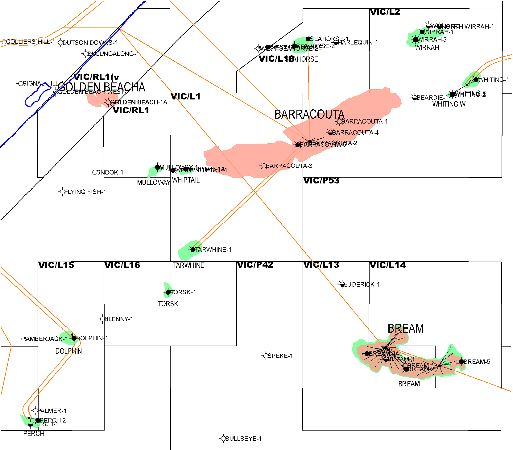
ORIGINAL WELL TITLE_NAME=VIC/L1
ORIGINAL WELL TITLE_NAME=VIC/L2
WELLS WITH THIS FIELD: WELL_NAME=BARRACOUTA-1
WELLS WITH THIS FIELD: WELL_NAME=BARRACOUTA-2
WELLS WITH THIS FIELD: WELL_NAME=BARRACOUTA-3
WELLS WITH THIS FIELD: WELL_NAME=BARRACOUTA-4
WELLS WITH THIS FIELD: WELL_NAME=BARRACOUTA-5
WELLS WITH THIS FIELD: WELL_NAME=BARRACOUTA-A1
WELLS WITH THIS FIELD: WELL_NAME=BARRACOUTA-A10
WELLS WITH THIS FIELD: WELL_NAME=BARRACOUTA-A2
WELLS WITH THIS FIELD: WELL_NAME=BARRACOUTA-A3
WELLS WITH THIS FIELD: WELL_NAME=BARRACOUTA-A3W
WELLS WITH THIS FIELD: WELL_NAME=BARRACOUTA-A4
WELLS WITH THIS FIELD: WELL_NAME=BARRACOUTA-A4A
WELLS WITH THIS FIELD: WELL_NAME=BARRACOUTA-A4A ST
WELLS WITH THIS FIELD: WELL_NAME=BARRACOUTA-A4A ST1
WELLS WITH THIS FIELD: WELL_NAME=BARRACOUTA-A5
WELLS WITH THIS FIELD: WELL_NAME=BARRACOUTA-A6
WELLS WITH THIS FIELD: WELL_NAME=BARRACOUTA-A7
WELLS WITH THIS FIELD: WELL_NAME=BARRACOUTA-A8
WELLS WITH THIS FIELD: WELL_NAME=BARRACOUTA-A9
LINKS FIELD ASSETS - GIPPSLAND OFFSHORE FIELDS = XSLF051
LINKS FIELD ASSETS - GIPPSLAND ON SHORE FIELDS = XSLF053
LINKS FIELD ASSETS - OTHER FIELDS = XSLF055
LINKS FIELD ASSETS - OTWAY OFFSHORE FIELDS = XSLF052
LINKS FIELD ASSETS - OTWAY ON SHORE FIELDS = XSLF054
LINKS FIELD BOX ASSETS sorted by location name = XSLF043
LINKS FIELD BOXES AND WELL ASSIGNED FIELDS = XSLF042
LINKS FIELD LIST = XSLF056
LINKS FIELD_BOXES_SORTED_BY_PERMIT
LINKS FIELD_BOX_ASSETS ( 0.7m )
LINKS LINKAGES TO FIELDS = XSLF042
FIELD SIZE= NAME=BARRACOUTA AVE_WATER_DEPTH = -45.7
FIELD SIZE= NAME=BARRACOUTA BASIN = GIPPSLAND
FIELD SIZE= NAME=BARRACOUTA CONSTRUCTION = STEEL JACKET
FIELD SIZE= NAME=BARRACOUTA COORD_TYPE = RADIO MAST
FIELD SIZE= NAME=BARRACOUTA DISCOVERY_DATE = 31-JAN-65
FIELD SIZE= NAME=BARRACOUTA FIELD_NAME = BARRACOUTA
FIELD SIZE= NAME=BARRACOUTA FIELD_SIZE_Ha = 7608
FIELD SIZE= NAME=BARRACOUTA G_FACTOR = 1.6
FIELD SIZE= NAME=BARRACOUTA LONG_NAME = BARRACOUTA
FIELD SIZE= NAME=BARRACOUTA ONSHORE_IND = N
FIELD SIZE= NAME=BARRACOUTA OPERATOR = ESSO
FIELD SIZE= NAME=BARRACOUTA O_FACTOR = 1.137
FIELD SIZE= NAME=BARRACOUTA PRIMARY_TITLE_NAME = VIC/L1
FIELD SIZE= NAME=BARRACOUTA PRODUCTION_START = 31-MAR-68
FIELD SIZE= NAME=BARRACOUTA PRODUCTS = OIL & GAS
FIELD SIZE= NAME=BARRACOUTA SECONDARY_TITLE_NAME = VIC/L2
FIELD SIZE= NAME=BARRACOUTA SHORT_NAME = BTA
FIELD SIZE= NAME=BARRACOUTA W_FACTOR = 1.03
BOX: GENERAL MAP_BOX PE000032 Barracouta Field N-1 Reservoir [CARDBOARD_BO] (?2007) 1 Enclosures 1 - 34 of Barracouta Field N-1 Reservoir Study, Gippsland Basin Gas fields Study Report Prepared for D. I. T. R.
BOX: TITLE FIELD_BOX PE180838 Barracouta Field Box 1 of 2 [CARDBOARD_BO] (?2000) 1 Barracouta Field Box 1 of 2
BOX: TITLE FIELD_BOX PE180929 Offshore GB Fields Production & Forecast[CARDBOARD_BO] (?2000) 1 Offshore GB Fields Production & Forecast
BOX: TITLE FIELD_BOX PE181586 Undeveloped Fields Box 1 of 3 [CARDBOARD_BO] (?2005) 1 Undeveloped Fields Box 1 of 3.
BOX: TITLE FIELD_BOX PE181736 Barracouta Field Box 2 [CARDBOARD_BO] (?2000) 1 Barracouta Field Box 2
BOX: TITLE FIELD_BOX PE183897 Field Reports [PAPER] (?1989) 1 Field reports for the Gippsland Gas Fields Study by ECL
RPT: GENERAL FIELD_RPT PE802652 Barracouta Field Mapping Report, Vol.1 [PAPER] (?1988) 1 PE802652__((_BARRACOUTA_FIELD_MAPPING_REPORT,_VOL.1_))_.TIF(1.6m)......... 1987 Barracouta Field Mapping Report, Vol.1,
RPT: GENERAL FIELD_RPT PE805269 Freshwater Influx in the Gippsland Basin[PAPER] (?1986) 1 PE805269__((_FRESHWATER_INFLUX_IN_THE_GIPPSLAND_BASIN_))_.TIF(0.9m)......... Freshwater Influx in the Gippsland Basin: Impact on Formation Evaluation, Hydrocarbon Volumes & Hydrocarbon Migration. By K. Kuttan, J.B. Kulla & R.G. Neumann of Esso Australia Ltd. Name of Publication: The APEA Journal and year 1986.
RPT: GENERAL RPT PE000001 Gippsland Basin Gas fields Study Report [PAPER] (?1989) 1 PE000001__((_GIPPSLAND_BASIN_GAS_FIELDS_STUDY_REPORT_))_.TIF(1.2m)......... Gippsland Basin Gas fields Study Summary Report Prepared for D. I. T. R.
RPT: GENERAL RPT PE000029 Barracouta Field N-1 Reservoir [PAPER] (?1989) 1 (13 DIGITAL FILES) Barracouta Field N-1 Reservoir, Gippsland Basin Gas fields Study Report Prepared for D. I. T. R.
RPT: GENERAL RPT PE706419 Oil&Gas Fields, Offshore Gippsland Basin[PAPER] (?1972) 1 Oil & Gas Field summaries of Offshore Gippsland Basin. Paper Print. From Oil and Gas fields of Australia, New Guinea and New Zealand. By Leslie R. Beddoes, Jr., Consulting Geologist.
RPT: SEISMIC PROC_RPT PE802652_026 Seismic Processing Report [PAPER] (?1988) 1 PE802652__((_BARRACOUTA_FIELD_MAPPING_REPORT,_VOL.1_))_.TIF(1.6m)......... Seismic Processing Report (Encl of Barracouta Field Mapping Report, Vol.1).
RPT: TITLE FIELD_RPT PE802660 Barracouta Field Mapping Report, Vol.2 [PAPER] (?1988) 1 PE802660__((_BARRACOUTA_FIELD_MAPPING_REPORT,_VOL.2_))_.TIF(0.4m)......... 1987 Barracouta Field Mapping Report, Vol.2.
RPT: TITLE REGIONAL_RPT PE910665 Barracouta Field History, Dev. & Geology[PAPER] (?1987) 1 PE910665__((_BARRACOUTA_FIELD_HISTORY,_DEV.___GEOLOGY_))_.TIF(1.7m)......... Barracouta: History of Exploration and Development & Geology of the Field, Gippsland Basin, By G.H.Roder and M.W.Sloan for Esso Australia Ltd., 1987.
RPT: WELL GEOCHEM_RPT PE800680 SUNFISH-1 HC Rpt-SubSurf.Gas [PAPER] (?1974) 1 PE800680__((_SUNFISH-1_HC_RPT-SUBSURF.GAS_))_.TIF(0.2m)......... Hydrocarbon Report - Subsurface Gas SUNFISH-1 well, FIT No.2, 6773 ft., Esso Australia Ltd., EPR-Production Engineering Division, September 1974, EPR.82PS.74
RPT: WELL GEOCHEM_RPT PE909621 MARLIN-A9,SNAPPER-A9 Gas Geochem.Analyse[PAPER] (?1991) 1 PE909621__((_MARLIN-A9,SNAPPER-A9_GAS_GEOCHEM.ANALYSE_))_.TIF(0.8m)......... Geochemical Analyses and Interpretation of the Gas Samples from the Barracouta, MARLIN-A9, and SNAPPER-A9 wells, Gippsland Basin, Australia. Exxon Production Research Company, Kevin M. Bohacs December 1991. Geoscience Research Application Report.
RPT: WELL RPT PE802681 Barracouta Field Report [PAPER] (?1978) 1 PE802681__((_BARRACOUTA_FIELD_REPORT_))_.TIF(1.7m)......... Barracouta Field Report, Gippsland Basin, By Esso/ D. Maughan, A. Mitchell, J. Gorter, Setp 1978
RPT: WELL RPT PE802682 Barracouta N-1 Reservoir, Drainage Study[PAPER] (?1975) 1 PE802682__((_BARRACOUTA_N-1_RESERVOIR,_DRAINAGE_STUDY_))_.TIF(3.6m).........PE802682__((_BARRACOUTA_N-1_RESERVOIR,_DRAINAGE_STUDY_))__038Y.TIF(0.1m)......... Barracouta N-1 Reservoir, Drainage Study, Gippsland Basin, By Esso Aust. Ltd./ W.V.inczeski, Dec-1978
RPT: WELL RPT PE804559 Barracouta Field Compilation Report [PAPER] (?2000) 1 PE804559__((_BARRACOUTA_FIELD_COMPILATION_REPORT_))_.TIF(0.4m)......... Barracouta Field Compilation Report, Gippsland Basin. (Map Enclosures from: Vic/L2 Quarterly Report, Oct-Dec 1977). Compiled by the Dept. of Natural Resources and Environment, on the 8-Dec-2000
RPT: WELL RPT PE804560 Barracouta Field Compilation Report [PAPER] (?2000) 1 PE804560__((_BARRACOUTA_FIELD_COMPILATION_REPORT_))_.TIF(0.1m)......... Barracouta Field Compilation Report, Barracouta Field, Gippsland Basin (Compiled by the Dept. Of Natural Resources and Environment on the 11-Dec-2000)
RPT: WELL RPT PE804711 Barracouta Field Compilation Report [PAPER] (?2000) 1 PE804711__((_BARRACOUTA_FIELD_COMPILATION_REPORT_))_.TIF(0.6m)......... Barracouta Field Compilation Report, Barracouta Field, Gippsland Basin, (Compiled by the Dept. of Natural Resources and Environment, 11-Dec-2000) By: Esso Exploration and Production Australia Inc.
RPT: WELL SRVY_RPT PE500055 ECL Res. Study. Gippsland Gas Fields [PAPER] (?1987) 1 (41 DIGITAL FILES) Proposal for a Reservoir Study of the Gippsland Gas Fields Barracouta, Marlin, SNAPPER, Turrum, Emperor And Kipper By ECL For The Department of Industry Technology and Resources, Melbourne, Victoria Australia. August 1987
RPT: WELL SRVY_RPT PE500056 ECL Res. Study. Gippsland Gas Fields [PAPER] (?1986) 1 PE500056__((_ECL_RES._STUDY._GIPPSLAND_GAS_FIELDS_))_.TIF(2.2m)......... Proposal for a Reservoir Study of the Gippsland Gas Fields SNAPPER, Marlin And Barracouta By ECL For The Department of Industry Technology and Resources, Melbourne, Victoria Australia. July 1986
GENERAL DNRE_COMPILATION PE804735 Barracouta Field Compilation Maps [PAPER] (?1988) 1 PE804735__((_BARRACOUTA_FIELD_COMPILATION_MAPS_))_.TIF(0.2m)......... Barracouta Field Compilation Maps, Barracouta Field, Gippsland Basin. (Compiled by the DRNE, 13-Dec-2000) By: Esso Exploration and Production Aust. Inc./ Ken Grieves
GENERAL DNRE_COMPILATION PE804737 Barracouta Field Early Studies Maps [PAPER] (?2000) 1 PE804737__((_BARRACOUTA_FIELD_EARLY_STUDIES_MAPS_))_.TIF(0.3m)......... Barracouta Field Early Studies Compilation Maps, Barracouta Field, Gippsland Basin, Compiled by DNRE on the 13-Dec-2000,
GENERAL FIELD_RPT PE802652 Barracouta Field Mapping Report, Vol.1 [PAPER] (?1988) 1 PE802652__((_BARRACOUTA_FIELD_MAPPING_REPORT,_VOL.1_))_.TIF(1.6m)......... 1987 Barracouta Field Mapping Report, Vol.1,
GENERAL FIELD_RPT PE805269 Freshwater Influx in the Gippsland Basin[PAPER] (?1986) 1 PE805269__((_FRESHWATER_INFLUX_IN_THE_GIPPSLAND_BASIN_))_.TIF(0.9m)......... Freshwater Influx in the Gippsland Basin: Impact on Formation Evaluation, Hydrocarbon Volumes & Hydrocarbon Migration. By K. Kuttan, J.B. Kulla & R.G. Neumann of Esso Australia Ltd. Name of Publication: The APEA Journal and year 1986.
GENERAL FIELD_RPT PE805269 Freshwater Influx in the Gippsland Basin[PAPER] (?1986) 2 PE805269__((_FRESHWATER_INFLUX_IN_THE_GIPPSLAND_BASIN_))_.TIF(0.9m)......... Freshwater Influx in the Gippsland Basin: Impact on Formation Evaluation, Hydrocarbon Volumes & Hydrocarbon Migration. By K. Kuttan, J.B. Kulla & R.G. Neumann of Esso Australia Ltd. Name of Publication: The APEA Journal and year 1986.
GENERAL GEOL_MAP PE804738 Subsurface Geological Map [PAPER] (?1965) 1 PE804738__((_SUBSURFACE_GEOLOGICAL_MAP_))_.TIF(2.3m)......... Subsurface Geological Map of Structure contours on Top of the Producing Gas Sand, Barracouta Field, Scale 1:50,000 (Enclosure in: Barracouta Field Early Studies Compilation Maps) by: Esso Exploration and Production Aust. Ltd.
GENERAL GEOL_MAP PE804742 Subsurface Geological Map [PAPER] (?1965) 1 PE804742__((_SUBSURFACE_GEOLOGICAL_MAP_))_.TIF(10.5m)......... Copy 2. Subsurface Geological Map of Structure Contours on Top of the Producing Gas Sand, Barracouta Field, Scale 1: 50,000 (Enclosure in: Barracouta Field Early Studies Compilation Maps) By: Esso Exploration and Production Aust. Inc
GENERAL GEOL_MAP PE804743 Subsurface Geological Map [PAPER] (?1965) 1 PE804743__((_SUBSURFACE_GEOLOGICAL_MAP_))_.TIF(3.4m)......... Copy 3. Subsurface Geological Map of Structure Contours on Top of the Producing Gas Sand, Barracouta Field, Scale 1: 50,000 (Enclosure in: Barracouta Field Early Studies Compilation Maps) By: Esso Exploration and Production Aust. Inc
GENERAL MAP_BOX PE000032 Barracouta Field N-1 Reservoir [CARDBOARD_BO] (?2007) 1 Enclosures 1 - 34 of Barracouta Field N-1 Reservoir Study, Gippsland Basin Gas fields Study Report Prepared for D. I. T. R.
GENERAL OBSOLETE_DESTROYED PE401385 Destroyed-Top Latrobe BARRA [PAPER] (?2000) 1 Destroyed - Gippsland Basin Area Vs Depth Plots For Top of Latrobe Group Barracouta Field; Plots for east & west fields for planimeter calculation of gross rock volumes; Area in Sq Km, Depth in m.
GENERAL REGISTRY_FILE F3005968 VIC/L01 / 1 Registry File [PAPER] (?1996) 1 VIC/L01 part1 PRODUCTION LICENCE FOR PETROLEUM HEMATITE PETROLEUM PTY LTD & ESSO EXPLORATION AND : PRODUCTION AUST LTD BARRACOUTA FIELD
GENERAL REGISTRY_FILE F3005969 VIC/L01 / 2 Registry File [PAPER] (?1996) 1 VIC/L01 part2 PRODUCTION LICENCE FOR PETROLEUM HEMATITE PETROLEUM PTY LTD & ESSO EXPLORATION AND : PRODUCTION AUST LTD BARRACOUTA FIELD
GENERAL REGISTRY_FILE F3005970 VIC/L01 / 3 Registry File [PAPER] (?1996) 1 VIC/L01 part3 PRODUCTION LICENCE FOR PETROLEUM HEMATITE PETROLEUM PTY LTD & ESSO EXPLORATION AND : PRODUCTION AUST LTD BARRACOUTA FIELD
GENERAL REGISTRY_FILE F3005971 VIC/L01 / 4 Registry File [PAPER] (?1996) 1 VIC/L01 part4 PRODUCTION LICENCE FOR PETROLEUM BHP PETROLEUM PTY LTD & ESSO AUSTRALIA LTD : BARRACOUTA FIELD RENEWAL
GENERAL REGISTRY_FILE F3006166 VIC/L02 / 1 Registry File [PAPER] (?1996) 1 VIC/L02 part1 PRODUCTION LICENCE FOR PETROLEUM *HEMATITE PETROLEUM PTY LTD : *ESSO EXPLORATION & PRODUCTION AUST LTD BARRACOUTA FIELD
GENERAL REGISTRY_FILE F3006167 VIC/L02 / 2 Registry File [PAPER] (?1996) 1 VIC/L02 part2 PRODUCTION LICENCE FOR PETROLEUM *HEMATITE PETROLEUM PTY LTD : *ESSO EXPLORATION & PRODUCTION AUST LTD BARRACOUTA FIELD
GENERAL REGISTRY_FILE F3025040 PE/18/0001 Registry File [PAPER] (?1997) 1 PE/18/0001 PETROLEUM FIELD - ALL BUT PRODUCTION RETURNS PRODUCTION LICENCE FOR PETROLEUM - VIC/L1 BARRACOUTA FIELD - SMALL OFFICE PROJECTS
GENERAL REGISTRY_FILE F3025042 PE/18/0002 Registry File [PAPER] (?1997) 1 PE/18/0002 PETROLEUM FIELD - ALL BUT PRODUCTION RETURNS PRODUCTION LICENCE FOR PETROLEUM - VIC/L1 BARRACOUTA FIELD - GENERAL
GENERAL REGISTRY_FILE F3025043 PE/18/0003 Registry File [PAPER] (?1997) 1 PE/18/0003 PETROLEUM FIELD - ALL BUT PRODUCTION RETURNS PRODUCTION LICENCE FOR PETROLEUM - VIC/L1 BARRACOUTA FIELD - PRODUCTION LICENCE INFORMATION
GENERAL REGISTRY_FILE F3025044 PE/18/0004 Registry File [PAPER] (?1997) 1 PE/18/0004 PETROLEUM FIELD - ALL BUT PRODUCTION RETURNS PRODUCTION LICENCE FOR PETROLEUM - VIC/L1 BARRACOUTA FIELD - EARLY STUDIES
GENERAL REGISTRY_FILE F3025045 PE/18/0005 Registry File [PAPER] (?1997) 1 PE/18/0005 PETROLEUM FIELD - ALL BUT PRODUCTION RETURNS PRODUCTION LICENCE FOR PETROLEUM - VIC/L1 BARRACOUTA FIELD - ENGINEERING
GENERAL REGISTRY_FILE F3025048 PE/18/0006 Registry File [PAPER] (?1997) 1 PE/18/0006 PETROLEUM FIELD - ALL BUT PRODUCTION RETURNS PRODUCTION LICENCE FOR PETROLEUM - VIC/L1 BARRACOUTA FIELD - CONSTRUCTION & EQUIPMENT
GENERAL REGISTRY_FILE F3025473 PE/14/0001 Registry File [PAPER] (?1997) 1 PE/14/0001 PETROLEUM FIELD - PRODUCTION RETURNS PRODUCTION LICENCE FOR PETROLEUM - VIC/L1 BARRACOUTA FIELD - ESSO AUSTRALIA LTD
GENERAL REGISTRY_FILE F3025509 PE/14/0001 Registry File [PAPER] (?1997) 1 PE/14/0001 PETROLEUM FIELD - PRODUCTION RETURNS PRODUCTION LICENCE FOR PETROLEUM - VIC/L1 BARRACOUTA FIELD - ESSO AUSTRALIA LTD
GENERAL REGISTRY_FILE F3025510 PE/14/0001 Registry File [PAPER] (?1997) 1 PE/14/0001 PETROLEUM FIELD - PRODUCTION RETURNS PRODUCTION LICENCE FOR PETROLEUM - VIC/L1 BARRACOUTA FIELD - ESSO AUSTRALIA LTD
GENERAL RPT PE000001 Gippsland Basin Gas fields Study Report [PAPER] (?1989) 1 PE000001__((_GIPPSLAND_BASIN_GAS_FIELDS_STUDY_REPORT_))_.TIF(1.2m)......... Gippsland Basin Gas fields Study Summary Report Prepared for D. I. T. R.
GENERAL RPT PE000001 Gippsland Basin Gas fields Study Report [PAPER] (?1989) 2 PE000001__((_GIPPSLAND_BASIN_GAS_FIELDS_STUDY_REPORT_))_.TIF(1.2m)......... Gippsland Basin Gas fields Study Summary Report Prepared for D. I. T. R.
GENERAL RPT PE000029 Barracouta Field N-1 Reservoir [PAPER] (?1989) 1 (13 DIGITAL FILES) Barracouta Field N-1 Reservoir, Gippsland Basin Gas fields Study Report Prepared for D. I. T. R.
GENERAL RPT PE706419 Oil&Gas Fields, Offshore Gippsland Basin[PAPER] (?1972) 1 Oil & Gas Field summaries of Offshore Gippsland Basin. Paper Print. From Oil and Gas fields of Australia, New Guinea and New Zealand. By Leslie R. Beddoes, Jr., Consulting Geologist.
GENERAL RPT PE706419 Oil&Gas Fields, Offshore Gippsland Basin[PAPER] (?1972) 2 Oil & Gas Field summaries of Offshore Gippsland Basin. Paper Print. From Oil and Gas fields of Australia, New Guinea and New Zealand. By Leslie R. Beddoes, Jr., Consulting Geologist.
OTHER_SRVY ISOPACH_MAP PE804744 Isopachs of Sediments Prospective [PAPER] (?1965) 1 PE804744__((_ISOPACHS_OF_SEDIMENTS_PROSPECTIVE_))__A.JPG(6.5m).........PE804744__((_ISOPACHS_OF_SEDIMENTS_PROSPECTIVE_))__A.TIF(0.4m).........PE804744__((_ISOPACHS_OF_SEDIMENTS_PROSPECTIVE_))__B.TIF(0.2m)......... Total Thickness Isopachs of Sediments Prospective for Petroleum, Barracouta Field, Scale 1: 1,000,000 (Enclosure in: Barracouta Field Early Studies Compilation Maps) By: Dept. of Mines Victoria
SEISMIC HRZN_CONTR_MAP PE402114 GB Barracouta Field Strc Map Top Latrobe[SEPIA] (?1986) 1 PE402114__((_GB_BARRACOUTA_FIELD_STRC_MAP_TOP_LATROBE_))_.TIF(1.4m)......... Gippsland Basin Barracouta Field - Top of Latrobe Group 'Coarse Clastics' Depth Structure Map also showing SP, pipeline, platform & well locns; VIC/P1, 11 & L1 & 2; incl numerous 1974-84 surveys; Scale: 1:25000.
SEISMIC HRZN_CONTR_MAP PE402115 GB Barracouta Field Struc Map LWR N.aspe[SEPIA] (?1986) 1 PE402115__((_GB_BARRACOUTA_FIELD_STRUC_MAP_LWR_N.ASPE_))_.TIF(0.7m)......... Gippsland Basin Barracouta Field - Lower N. asperus Seismic Marker Depth Structure Map also showing SP, pipeline, platform & well locns; VIC/P1, 11 & L1 & 2; incl numerous 1974-84 surveys; Scale: 1:100000.
SEISMIC HRZN_CONTR_MAP PE402116 GB Barracouta Field Struc Map M.diversus[SEPIA] (?1986) 1 PE402116__((_GB_BARRACOUTA_FIELD_STRUC_MAP_M.DIVERSUS_))_.TIF(1.0m)......... Gippsland Basin Barracouta Field - M. diversus Seismic Marker Depth Structure Map also showing SP, pipeline, platform & well locns; VIC/P1, 11 & L1 & 2; incl numerous 1974-84 surveys; Scale: 1:100000.
SEISMIC HRZN_CONTR_MAP PE802659 Barracouta Field Sag Velocity [PAPER] (?1988) 1 PE802659__((_BARRACOUTA_FIELD_SAG_VELOCITY_))_.TIF(1.2m)......... 1987 Barracouta Field, 'Sag' Compensation Velocity Contour Map. Scale: 1:25000, Contour interval: 2 m/sec. Enclosure 2 from Barracouta Field Mapping Report, September 1987. SEE REMARKS.
SEISMIC HRZN_CONTR_MAP PE802663 Barracouta Field Structure Map [PAPER] (?1988) 1 PE802663__((_BARRACOUTA_FIELD_STRUCTURE_MAP_))_.TIF(1.8m)......... 1987 Barracouta Field, Structure Map Top of the Latrobe Group 'Coarse Clastics'. Scale: 1:25000. Enclosure 10 from Barracouta Field Mapping Report, September 1987.
SEISMIC HRZN_CONTR_MAP PE802664 Barracouta Field Structure Map [PAPER] (?1988) 1 PE802664__((_BARRACOUTA_FIELD_STRUCTURE_MAP_))_.TIF(1.6m)......... 1987 Barracouta Field, Structure Map 48.5 M.Y. Sequence Boundary ( Lower N.asperus Seismic Marker). Scale: 1:25000. Enclosure 11 from Barracouta Field Mapping Report, September 1987.
SEISMIC HRZN_CONTR_MAP PE802665 Barracouta Field Structure Map [PAPER] (?1988) 1 PE802665__((_BARRACOUTA_FIELD_STRUCTURE_MAP_))_.TIF(1.2m)......... 1987 Barracouta Field, Structure Map Top of M-1 Reservoir. Scale: 1:25000. Enclosure 12 from Barracouta Field Mapping Report, September 1987.
SEISMIC HRZN_CONTR_MAP PE802670 Barracouta Field Structure Map -2nd Copy[PAPER] (?1987) 1 PE802670__((_BARRACOUTA_FIELD_STRUCTURE_MAP_-2ND_COPY_))_.TIF(1.4m)......... 1987 Barracouta Field, Structure Map, Top of M-1 Reservoir (second copy of map). Scale: 1:25000, Contour Interval 10m.
SEISMIC HRZN_CONTR_MAP PE802671 Barracouta Field Structure Map [PAPER] (?1987) 1 PE802671__((_BARRACOUTA_FIELD_STRUCTURE_MAP_))_.TIF(1.4m)......... 1987 Barracouta Field, Structure Map, Sequence Boundary 'F'. Scale: 1:25000, Contour Interval 10m.
SEISMIC HRZN_CONTR_MAP PE802672 Barracouta Field Structure Map -2nd copy[PAPER] (?1988) 1 PE802672__((_BARRACOUTA_FIELD_STRUCTURE_MAP_-2ND_COPY_))_.TIF(1.7m)......... 1987 Barracouta Field, Structure Map, Top of Latrobe Group 'Coarse Clastics' (Second Copy). Scale: 1:25000, Contour Interval 10m.
SEISMIC HRZN_CONTR_MAP PE802673 Barracouta Field Structure Map -3rd copy[PAPER] (?1988) 1 PE802673__((_BARRACOUTA_FIELD_STRUCTURE_MAP_-3RD_COPY_))_.TIF(1.8m)......... 1987 Barracouta Field, Structure Map, Top of Latrobe Group 'Coarse Clastics' (Third Copy). Scale: 1:25000, Contour Interval: 10m.
SEISMIC HRZN_CONTR_MAP PE804573 Depth Structure Map-Lower N. asperus [PAPER] (?1977) 1 PE804573__((_DEPTH_STRUCTURE_MAP-LOWER_N._ASPERUS_))_.TIF(0.9m)......... Depth Structure Map-Near-Base of Lower N. asperus, Barracouta Field, Gippsland Basin, Scale 1: 50,000, (Plate 15 in: Barracouta Field Compilation Report), By: Esso Exploration and Production Aust./ D.M Maughan
SEISMIC HRZN_CONTR_MAP PE804574 Depth Structure Map-Top of Latrobe Group[PAPER] (?1977) 1 PE804574__((_DEPTH_STRUCTURE_MAP-TOP_OF_LATROBE_GROUP_))_.TIF(0.9m)......... Depth Structure Map- Top of Latrobe Group, Barracouta Field, Gippsland Basin, Scale 1: 50,000, (Plate 13 in: Barracouta Field Compilation Report), By: Esso Exploration and Production Aust./ D.M Maughan
SEISMIC HRZN_CONTR_MAP PE804575 Depth Structure Map-Brown Horizon [PAPER] (?1977) 1 PE804575__((_DEPTH_STRUCTURE_MAP-BROWN_HORIZON_))_.TIF(0.9m)......... Depth Structure Map- Brown Horizon (Possible top of Coarse Clastics), Barracouta Field, Gippsland Basin, Scale 1: 50,000, (Plate 14 in: Barracouta Field Compilation Report), By: Esso Exploration and Production Aust./ D.M Maughan
SEISMIC HRZN_CONTR_MAP PE804576 Depth Structure Map-Top of M-1 Reservoir[PAPER] (?1977) 1 PE804576__((_DEPTH_STRUCTURE_MAP-TOP_OF_M-1_RESERVOIR_))_.TIF(0.7m)......... Depth Structure Map-Top of M-1 Reservoir, Barracouta Field, Gippsland Basin, Scale 1: 25,000, (Plate 16 in: Barracouta Field Compilation Report), By: Esso Exploration and Production Aust./ D.M Maughan
SEISMIC HRZN_CONTR_MAP PE804577 Depth Structure Map-Latrobe Group [PAPER] (?1977) 1 PE804577__((_DEPTH_STRUCTURE_MAP-LATROBE_GROUP_))_.TIF(0.9m)......... Depth Structure Map-Top of Latrobe Group (Maximum Case), Barracouta Field, Gippsland Basin, Scale 1: 50,000, (Plate 17 in: Barracouta Field Compilation Report), By: Esso Exploration and Production Aust./ D.M Maughan
SEISMIC HRZN_CONTR_MAP PE804578 Depth Structure Map-Latrobe Group [PAPER] (?1977) 1 PE804578__((_DEPTH_STRUCTURE_MAP-LATROBE_GROUP_))_.TIF(0.9m)......... Depth Structure Map-Top of Latrobe Group (MinimumCase), Barracouta Field, Gippsland Basin, Scale 1: 50,000, (Plate 18 in: Barracouta Field Compilation Report), By: Esso Exploration and Production Aust./ D.M Maughan
SEISMIC HRZN_CONTR_MAP PE804579 Depth Structure Map- Top of M-1 Oil Sand[PAPER] (?1977) 1 PE804579__((_DEPTH_STRUCTURE_MAP-_TOP_OF_M-1_OIL_SAND_))_.TIF(0.3m)......... Depth Structure Map- Top of M-1 Oil Sand, Barracouta Field, Gippsland Basin, Scale 1: 25,000, (Plate in: Barracouta Field Compilation Report), By: Esso Exploration and Production Aust./ D.M Maughan and A. Mitchell.
SEISMIC HRZN_CONTR_MAP PE804584 Structure Map- Top of Latrobe Group [PAPER] (?1974) 1 PE804584__((_STRUCTURE_MAP-_TOP_OF_LATROBE_GROUP_))_.TIF(1.0m)......... Structure Map- Top of Latrobe Group (N-1 Reservoir), Barracouta Field, Gippsland Basin, Scale 1:25,000 (Plate in: Barracouta Field Compilation Report), By: Esso Exploration and Production Aust./ J. Bordelon.
SEISMIC HRZN_CONTR_MAP PE804585 Structure Map- Top of Latrobe Group [PAPER] (?1974) 1 PE804585__((_STRUCTURE_MAP-_TOP_OF_LATROBE_GROUP_))_.TIF(2.1m)......... Structure Map- Top of Latrobe Group (N-1 Reservoir) Base on D.H.I velocities, Barracouta Field, Gippsland Basin, Scale 1:25,000 (Plate III in: Barracouta Field Compilation Report), By: Esso Exploration and Production Aust./ J. Bordelon.
SEISMIC HRZN_CONTR_MAP PE804586 Structure Map- Top of M-1 Oil Sand [PAPER] (?1974) 1 PE804586__((_STRUCTURE_MAP-_TOP_OF_M-1_OIL_SAND_))_.TIF(0.4m)......... Structure Map- Top of M-1 Oil Sand, Barracouta Field, Gippsland Basin, Scale 1:25,000 (Plate in: Barracouta Field Compilation Report), By: Esso Exploration and Production Aust./ J. Bordelon.
SEISMIC HRZN_CONTR_MAP PE804587 Structure Contour Map- Top of Latrobe [PAPER] (?1970) 1 PE804587__((_STRUCTURE_CONTOUR_MAP-_TOP_OF_LATROBE_))_.TIF(10.0m)......... Interpretative Structure Contour Map- Top of Latrobe Group, (Enclosure in: Barracouta Field Compilation Report), Barracouta Field, Gippsland Basin, Scale 1: 250,000
SEISMIC HRZN_CONTR_MAP PE804588 Structure Map- Top of Latrobe [PAPER] (?1972) 1 PE804588__((_STRUCTURE_MAP-_TOP_OF_LATROBE_))_.TIF(1.2m)......... Structure Map- Top of Latrobe Group, Barracouta Field, Gippsland Basin, scale 1:250,000 (Enclosure in: Barracouta Field Compilation Report) by Esso Australia Ltd.
SEISMIC HRZN_CONTR_MAP PE804708 Depth Structure Map Brown Horizon [PAPER] (?1977) 1 PE804708__((_DEPTH_STRUCTURE_MAP_BROWN_HORIZON_))_.TIF(1.0m)......... Depth Structure Map Brown Horizon (Possible top of Coarse Clastics), Barracouta Field. By Esso Exploration and Production Inc. Plate 14, Scale 1:50000, CI: 100ft
SEISMIC HRZN_CONTR_MAP PE804709 Depth Structure Map near base Lower N.as[PAPER] (?1977) 1 PE804709__((_DEPTH_STRUCTURE_MAP_NEAR_BASE_LOWER_N.AS_))_.TIF(0.9m)......... Depth Structure Map near base of Lower N.asperus, Barracouta Field. By Esso Exploration and Production Inc. Plate 15, Scale 1:50000, CI: 100 ft
SEISMIC HRZN_CONTR_MAP PE804712 Depth Structure Map-Top of M-1 Reservoir[PAPER] (?1977) 1 PE804712__((_DEPTH_STRUCTURE_MAP-TOP_OF_M-1_RESERVOIR_))_.TIF(0.4m)......... Depth Structure Map-Top of M-1 Reservoir, Barracouta Field, Gippsland Basin, Scale 1:25,000 ( Enclosure XVI in: Barracouta Field Compilation Report), By: Esso Exploration and Production Australia Inc./A. Mitchell and D. Maughan
SEISMIC HRZN_CONTR_MAP PE804713 Depth Structure Map-Top of Latrobe Group[PAPER] (?1978) 1 PE804713__((_DEPTH_STRUCTURE_MAP-TOP_OF_LATROBE_GROUP_))_.TIF(1.0m)......... Depth Structure Map-Top of Latrobe Group (Maximum Case), Barracouta Field, Gippsland Basin, Scale 1:50,000 ( Enclosure XVII in: Barracouta Field Compilation Report), By: Esso Exploration and Production Aust. Inc./A. Mitchell and J. Gortor
SEISMIC HRZN_CONTR_MAP PE804714 Depth Structure Map-Top of Latrobe Group[PAPER] (?1978) 1 PE804714__((_DEPTH_STRUCTURE_MAP-TOP_OF_LATROBE_GROUP_))_.TIF(0.8m)......... Depth Structure Map-Top of Latrobe Group (Minimum Case), Barracouta Field, Gippsland Basin, Scale 1:50,000 ( Enclosure XVIII in: Barracouta Field Compilation Report), By: Esso Exploration and Production Aust. Inc./G. Gortor and D. Maughan
SEISMIC HRZN_CONTR_MAP PE804721 Structure Map-Top of N-1 Reservoir [PAPER] (?1978) 1 PE804721__((_STRUCTURE_MAP-TOP_OF_N-1_RESERVOIR_))_.TIF(0.9m)......... Structure Map-Top of N-1 Reservoir, Barracouta Field, Gippsland Basin, Scale 1:50,000 ( Enclosure XXV in: Barracouta Field Compilation Report), By: Esso Exploration and Production Aust. Inc./J. Gorter
SEISMIC HRZN_CONTR_MAP PE804722 Structure Map-Base of Main Coal Horizon [PAPER] (?1978) 1 PE804722__((_STRUCTURE_MAP-BASE_OF_MAIN_COAL_HORIZON_))_.TIF(1.0m)......... Structure Map-Base of Main Coal Horizon (Near Base Of Lower N.asperus), Barracouta Field, Gippsland Basin, Scale 1:50,000 ( Enclosure XXVI in: Barracouta Field Compilation Report), By: Esso Exploration and Production Aust. Inc.
SEISMIC HRZN_CONTR_MAP PE804723 Structure Map-Top of N-1.2 Reservoir [PAPER] (?1978) 1 PE804723__((_STRUCTURE_MAP-TOP_OF_N-1.2_RESERVOIR_))_.TIF(0.9m)......... Structure Map-Top of N-1.2 Reservoir, Barracouta Field, Gippsland Basin, Scale 1:50,000 ( Enclosure XXVII in: Barracouta Field Compilation Report), By: Esso Exploration and Production Aust. Inc.
SEISMIC HRZN_CONTR_MAP PE804726 Structure Map. Top of N-1 Reservoir [PAPER] (?1978) 1 PE804726__((_STRUCTURE_MAP._TOP_OF_N-1_RESERVOIR_))_.TIF(0.9m)......... Structure Map. Top of N-1 Reservoir (Maximum Case), Barracouta Field. Scale: 1:50,000. (Enclosure XXX in: Barracouta Field Compilation Report, DNRE, 2000) By: Esso Exploration and Production Aust. Inc. Author: J.D Gorter, July 1978.
SEISMIC HRZN_CONTR_MAP PE804727 Structure Map. Top of N-1 Reservoir [PAPER] (?1978) 1 PE804727__((_STRUCTURE_MAP._TOP_OF_N-1_RESERVOIR_))_.TIF(0.9m)......... Structure Map. Top of N-1 Reservoir (Minimum Case), Barracouta Field. Scale: 1:50,000. (Enclosure XXXI in: Barracouta Field Compilation Report, DNRE, 2000) By: Esso Exploration and Production Aust. Inc. Author: J.D Gorter, July 1978.
SEISMIC HRZN_CONTR_MAP PE804728 Structure Map. Top of N-1.2 Reservoir [PAPER] (?1978) 1 PE804728__((_STRUCTURE_MAP._TOP_OF_N-1.2_RESERVOIR_))_.TIF(0.9m)......... Structure Map. Top of N-1.2 Reservoir (Maximum Case), Barracouta Field. Scale: 1:50,000. (Enclosure XXXII in: Barracouta Field Compilation Report, DNRE, 2000) By: Esso Exploration and Production Aust. Inc. Author: J.D Gorter, July 1978.
SEISMIC HRZN_CONTR_MAP PE804729 Structure Map. Top of N-1.2 Reservoir [PAPER] (?1978) 1 PE804729__((_STRUCTURE_MAP._TOP_OF_N-1.2_RESERVOIR_))_.TIF(0.9m)......... Structure Map. Top of N-1.2 Reservoir (Minimum Case), Barracouta Field. Scale: 1:50,000. (Enclosure XXXIII in: Barracouta Field Compilation Report, DNRE, 2000) By: Esso Exploration and Production Aust. Inc. Author: J.D Gorter, July 1978.
SEISMIC HRZN_CONTR_MAP PE804740 Structure Contour and Isopach Map [TRACING_PAPE] (?1965) 1 PE804740__((_STRUCTURE_CONTOUR_AND_ISOPACH_MAP_))_.JPG(6.5m).........PE804740__((_STRUCTURE_CONTOUR_AND_ISOPACH_MAP_))_.TIF(0.4m)......... Structure Contours on Top of the Producing Gas Sand and Isopachs of the Gas Reservoir Interpretation modification from interpretation of Esso Dated 22-8-65, Barracouta Field, (Enclosure in: Barracouta Field Early Studies Compilation Maps)
SEISMIC INTERP_SECTION PE302035 G77A-3023 Migrated Section [PAPER] (?1989) 1 G77A-3023 Migrated Geoseismic Section. Enclosure of Barracouta Field N-1 Reservoir Study, Gippsland Basin Gas fields Study Report Prepared for D. I. T. R.
SEISMIC INTERP_SECTION PE302036 G77A-3024 Migrated Section [PAPER] (?1989) 1 G77A-3024 Migrated Geoseismic Section. Enclosure of Barracouta Field N-1 Reservoir Study, Gippsland Basin Gas fields Study Report Prepared for D. I. T. R.
SEISMIC INTERP_SECTION PE605512 BARRACOUTA-1 BCA Fld Interp.Seis.Line [PAPER] (?1988) 1 PE605512__((_BARRACOUTA-1_BCA_FLD_INTERP.SEIS.LINE_))_.TIF(5.7m)......... 1987 Barracouta Field, Interpreted Seismic Line G84A-7100. Enclosure 15 from Barracouta Field Mapping Report, September 1987. Line G84A-7100, S.P: 2189-1953, Esso Aust. LTD1984, Central Barracouta 2D.
SEISMIC ISOCHRON_MAP PE802653 Barracouta Field Time Structure Map [PAPER] (?1987) 1 PE802653__((_BARRACOUTA_FIELD_TIME_STRUCTURE_MAP_))_.TIF(1.6m)......... 1987 Barracouta Field, Time Structure Map Top of Latrobe Group 'Coarse Clastics'. Scale: 1:25000. Enclosure 1 from Barracouta Field Mapping Report, September 1987.
SEISMIC ISOCHRON_MAP PE802654 Barracouta Field Time Structure Map [PAPER] (?1987) 1 PE802654__((_BARRACOUTA_FIELD_TIME_STRUCTURE_MAP_))_.TIF(1.5m)......... 1987 Barracouta Field, Time Structure Map 48.5 M.Y. Sequence Boundary (Lower N.asperus seismic marker. Scale: 1:25000. Enclosure 2 from Barracouta Field Mapping Report, September 1987.
SEISMIC ISOCHRON_MAP PE802655 Barracouta Field Time Structure Map [PAPER] (?1987) 1 PE802655__((_BARRACOUTA_FIELD_TIME_STRUCTURE_MAP_))_.TIF(1.3m)......... 1987 Barracouta Field, Time Structure Map, Top of M-1 Reservoir. Scale: 1:25000. Enclosure 3 from Barracouta Field Mapping Report, September 1987.
SEISMIC ISOCHRON_MAP PE802668 Whiptail Trend Time Structure Map [PAPER] (?1987) 1 PE802668__((_WHIPTAIL_TREND_TIME_STRUCTURE_MAP_))_.TIF(0.7m)......... 1987 Gippsland Basin, Whiptail Trend Time Structure Map, Top of Latrobe Group 'Coarse Clastics'. Scale 1:25000, Contour interval: .010sec.
SEISMIC ISOCHRON_MAP PE802669 Whiptail Trend Time Structure Map [PAPER] (?1987) 1 PE802669__((_WHIPTAIL_TREND_TIME_STRUCTURE_MAP_))_.TIF(0.6m)......... 1987 Gippsland Basin, Whiptail Trend Time Structure Map, Sequence Boundary 'F' (Near top of N-1.1 Sand). Scale 1:25000, Contour interval: .010sec.
SEISMIC ISOCHRON_MAP PE802674 Barracouta Field Time Structure Map [PAPER] (?1987) 1 PE802674__((_BARRACOUTA_FIELD_TIME_STRUCTURE_MAP_))_.TIF(1.6m)......... 1987 Barracouta Field, Time Structure Map, Sequence Boundary 'F'. Scale: 1:25000, Contour Interval: .010sec .
SEISMIC ISOCHRON_MAP PE802675 Barracouta Field structure Map -2nd copy[PAPER] (?1987) 1 PE802675__((_BARRACOUTA_FIELD_STRUCTURE_MAP_-2ND_COPY_))_.TIF(1.4m)......... 1987 Barracouta Field, Time Structure Map, Top Of M-1 Reservoir (Second Copy). Scale: 1:25000, Contour Interval: .010sec .
SEISMIC ISOCHRON_MAP PE802676 Barracouta Field structure Map -2nd copy[PAPER] (?1987) 1 PE802676__((_BARRACOUTA_FIELD_STRUCTURE_MAP_-2ND_COPY_))_.TIF(1.7m)......... 1987 Barracouta Field, Time Structure Map, Top Of Latrobe Group 'Coarse Clastics' (Second Copy). Scale: 1:25000, Contour Interval: .010sec
SEISMIC ISOCHRON_MAP PE804561 Time Structure Map- Green Horizon [PAPER] (?1977) 1 PE804561__((_TIME_STRUCTURE_MAP-_GREEN_HORIZON_))_.TIF(1.1m)......... Time Structure Map- Green Horizon, Barracouta Field, Gippsland Basin, Scale1: 50,000, (Plate 1 in: Barracouta Field Compilation Report), By: Esso Exploration and Production Aust./ D.M Maughan
SEISMIC ISOCHRON_MAP PE804562 Time Structure Map- Red Horizon [PAPER] (?1977) 1 PE804562__((_TIME_STRUCTURE_MAP-_RED_HORIZON_))_.TIF(0.9m)......... Time Structure Map- Red Horizon, Barracouta Field, Gippsland Basin, Scale1: 50,000, (Plate 2 in: Barracouta Field Compilation Report), By: Esso Exploration and Production Aust./ D.M Maughan
SEISMIC ISOCHRON_MAP PE804563 Time Structure Map- Top of Latrobe [PAPER] (?1977) 1 PE804563__((_TIME_STRUCTURE_MAP-_TOP_OF_LATROBE_))_.TIF(1.1m)......... Time Structure Map- Top of Latrobe, Barracouta Field, Gippsland Basin, Scale1: 50,000, (Plate 3 in: Barracouta Field Compilation Report), By: Esso Exploration and Production Aust./ D.M Maughan
SEISMIC ISOCHRON_MAP PE804564 Time Structure Map- Brown Horizon [PAPER] (?1977) 1 PE804564__((_TIME_STRUCTURE_MAP-_BROWN_HORIZON_))_.TIF(1.2m)......... Time Structure Map- Brown Horizon, Barracouta Field, Gippsland Basin, Scale1: 50,000, (Plate 4 in: Barracouta Field Compilation Report), By: Esso Exploration and Production Aust./ D.M Maughan
SEISMIC ISOCHRON_MAP PE804565 Time Structure Map-Base of N. asperus [PAPER] (?1977) 1 PE804565__((_TIME_STRUCTURE_MAP-BASE_OF_N._ASPERUS_))_.TIF(1.0m)......... Time Structure Map- Near Base of Lower N. asperus, Barracouta Field, Gippsland Basin, Scale1: 50,000, (Plate 5 in: Barracouta Field Compilation Report), By: Esso Exploration and Production Aust./ D.M Maughan
SEISMIC ISOCHRON_MAP PE804566 Time Structure Map-Top M-1 Reservoir [PAPER] (?1977) 1 PE804566__((_TIME_STRUCTURE_MAP-TOP_M-1_RESERVOIR_))_.TIF(0.4m)......... Time Structure Map- Top of M-1 Reservoir, Barracouta Field, Gippsland Basin, Scale1: 25,000, (Plate 6 in: Barracouta Field Compilation Report), By: Esso Exploration and Production Aust./ D.M Maughan
SEISMIC ISOCHRON_MAP PE804567 Isochron Map-Top Latrobe to N.asperus [PAPER] (?1977) 1 PE804567__((_ISOCHRON_MAP-TOP_LATROBE_TO_N.ASPERUS_))_.TIF(0.9m)......... Time Structure Map-Top of Latrobe Group to near-base of Lower N.asperus, Barracouta Field, Gippsland Basin, Scale1: 50,000, (Plate 7 in: Barracouta Field Compilation Report), By: Esso Exploration and Production Aust./ D.M Maughan
SEISMIC ISOCHRON_MAP PE804695 Time Structure Map Green Horizon [PAPER] (?1977) 1 PE804695__((_TIME_STRUCTURE_MAP_GREEN_HORIZON_))_.TIF(0.9m)......... Time Structure Map Green Horizon, Barracouta Field. By Esso Exploration and Production Inc. Plate 1, Scale 1:50000, CI: 0.05s
SEISMIC ISOCHRON_MAP PE804696 Time Structure Map Red Horizon [PAPER] (?1977) 1 PE804696__((_TIME_STRUCTURE_MAP_RED_HORIZON_))_.TIF(1.0m)......... Time Structure Map Red Horizon, Barracouta Field. By Esso Exploration and Production Inc. Plate 2, Scale 1:50000, CI: 0.05s
SEISMIC ISOCHRON_MAP PE804697 Time Structure Map Top of Latrobe Grp [PAPER] (?1977) 1 PE804697__((_TIME_STRUCTURE_MAP_TOP_OF_LATROBE_GRP_))_.TIF(1.0m)......... Time Structure Map Top of Latrobe Group, Barracouta Field. By Esso Exploration and Production Inc. Plate 3, Scale 1:50000, CI: 0.01s
SEISMIC ISOCHRON_MAP PE804698 Time Structure Map Brown Horizon [PAPER] (?1977) 1 PE804698__((_TIME_STRUCTURE_MAP_BROWN_HORIZON_))_.TIF(1.0m)......... Time Structure Map Brown Horizon (Possible Coarse Clastics), Barracouta Field. By Esso Exploration and Production Inc. Plate 4, Scale 1:50000, CI: 0.01s
SEISMIC ISOCHRON_MAP PE804699 Time Structure Map near base Lower N.asp[PAPER] (?1977) 1 PE804699__((_TIME_STRUCTURE_MAP_NEAR_BASE_LOWER_N.ASP_))_.TIF(0.9m)......... Time Structure Map near baseof Lower N.asperus, Barracouta Field. By Esso Exploration and Production Inc. Plate 5, Scale 1:50000, CI: 0.025s
SEISMIC ISOCHRON_MAP PE804700 Time Structure Map top of M-1 Reservoir [PAPER] (?1977) 1 PE804700__((_TIME_STRUCTURE_MAP_TOP_OF_M-1_RESERVOIR_))_.TIF(0.3m)......... Time Structure Map top of M-1 Reservoir, Barracouta Field. By Esso Exploration and Production Inc. Plate 6, Scale 1:25000, CI: 0.01s
SEISMIC ISOCHRON_MAP PE804701 Isochron Map top Latrobe base Lower N.as[PAPER] (?1977) 1 PE804701__((_ISOCHRON_MAP_TOP_LATROBE_BASE_LOWER_N.AS_))_.TIF(0.9m)......... Isochron Map top of Latrobe Group to near base of Lower N.asperus, Barracouta Field. By Esso Exploration and Production Inc. Plate 7, Scale 1:50000, CI: 0.01s
SEISMIC ISOPACH_MAP PE706057 Sub Zone N-1.1 Gross Isopach Map [PAPER] (?1989) 1 Sub Zone N-1.1 Gross Isopach Map. Enclosure of Barracouta Field N-1 Reservoir Study, Gippsland Basin Gas fields Study Report Prepared for D. I. T. R.
SEISMIC ISOPACH_MAP PE706058 Sub Zone N-1.1 Iso Net/Gross Map [PAPER] (?1989) 1 Sub Zone N-1.1 Iso Net/Gross Map. Enclosure of Barracouta Field N-1 Reservoir Study, Gippsland Basin Gas fields Study Report Prepared for D. I. T. R.
SEISMIC ISOPACH_MAP PE706060 Sub Zone N-1.2 Gross Isopach Map [PAPER] (?1989) 1 Sub Zone N-1.2 Gross Isopach Map. Enclosure of Barracouta Field N-1 Reservoir Study, Gippsland Basin Gas fields Study Report Prepared for D. I. T. R.
SEISMIC ISOPACH_MAP PE706061 Sub Zone N-1.2 Iso net/gross Map [PAPER] (?1989) 1 Sub Zone N-1.2 Iso Net/Gross Map. Enclosure of Barracouta Field N-1 Reservoir Study, Gippsland Basin Gas fields Study Report Prepared for D. I. T. R.
SEISMIC ISOPACH_MAP PE706063 Sub Zone N-1.3 Gross Isopach Map [PAPER] (?1989) 1 Sub Zone N-1.3 Gross Isopach Map. Enclosure of Barracouta Field N-1 Reservoir Study, Gippsland Basin Gas fields Study Report Prepared for D. I. T. R.
SEISMIC ISOPACH_MAP PE706064 Sub Zone N-1.3 Iso Net/Gross Map [PAPER] (?1989) 1 Sub Zone N-1.3 Iso Net/Gross Map. Enclosure of Barracouta Field N-1 Reservoir Study, Gippsland Basin Gas fields Study Report Prepared for D. I. T. R.
SEISMIC ISOPACH_MAP PE706066 Sub Zone N-1.3 Gross Isopach Map [PAPER] (?1989) 1 Sub Zone N-1.3 Gross Isopach Map. Enclosure of Barracouta Field N-1 Reservoir Study, Gippsland Basin Gas fields Study Report Prepared for D. I. T. R.
SEISMIC ISOPACH_MAP PE706067 Sub Zone N-1.4 Iso Net/Gross Map [PAPER] (?1989) 1 Sub Zone N-1.4 Iso Net/Gross Map. Enclosure of Barracouta Field N-1 Reservoir Study, Gippsland Basin Gas fields Study Report Prepared for D. I. T. R.
SEISMIC ISOPACH_MAP PE804580 Nett Oil Isopach- Top of M-1 Oil Sand [PAPER] (?1977) 1 PE804580__((_NETT_OIL_ISOPACH-_TOP_OF_M-1_OIL_SAND_))_.TIF(0.4m)......... Nett Oil Isopach- Top of M-1 Oil Sand copy 2, Barracouta Field, Gippsland Basin, Scale 1: 25,000, (Plate in: Barracouta Field Compilation Report), By: Esso Exploration and Production Aust./ A. Mitchell.
SEISMIC ISOPACH_MAP PE804581 Gross Isopach- M-1 Oil Sand [PAPER] (?1977) 1 PE804581__((_GROSS_ISOPACH-_M-1_OIL_SAND_))_.TIF(0.4m)......... Gross Isopach- M-1 Oil Sand Copy 2, Barracouta Field, Gippsland Basin, Scale 1: 25,000, (Plate in: Barracouta Field Compilation Report), By: Esso Exploration and Production Aust./ A. Mitchell.
SEISMIC ISOPACH_MAP PE804715 Net Gas Isopach N 1.1 Reservoir [PAPER] (?1978) 1 PE804715__((_NET_GAS_ISOPACH_N_1.1_RESERVOIR_))_.TIF(0.8m)......... Net Gas Isopach N 1.1 Reservoir, Barracouta Field. Scale: 1:50,000. (Enclosure XXVIII in: Barracouta Field Compilation Report, DNRE, 2000) By: Esso Exploration and Production Aust. Inc. Author: J.D Gorter, July 1978.
SEISMIC ISOPACH_MAP PE804718 Gross Isopach M-1 Oil Sand [PAPER] (?1977) 1 PE804718__((_GROSS_ISOPACH_M-1_OIL_SAND_))_.TIF(0.3m)......... Gross Isopach M-1 Oil Sand, Barracouta Field, Gippsland Basin, Scale 1:25,000 ( Enclosure XXI in: Barracouta Field Compilation Report), By: Esso Exploration and Production Aust. Inc./A. Mitchell
SEISMIC ISOPACH_MAP PE804719 Nett Isopach M-1 Oil Sand [PAPER] (?1977) 1 PE804719__((_NETT_ISOPACH_M-1_OIL_SAND_))_.TIF(0.3m)......... Nett Isopach M-1 Oil Sand, Barracouta Field, Gippsland Basin, Scale 1:25,000 ( Enclosure XXII in: Barracouta Field Compilation Report), By: Esso Exploration and Production Aust. Inc./A. Mitchell
SEISMIC ISOPACH_MAP PE804725 Gross Gas Isopach N 1.2 Reservoir [PAPER] (?1978) 1 PE804725__((_GROSS_GAS_ISOPACH_N_1.2_RESERVOIR_))_.TIF(0.8m)......... Gross Gas Isopach N 1.2 Reservoir (90% net), Barracouta Field. Scale: 1:50,000. (Enclosure XXIX in: Barracouta Field Compilation Report, DNRE, 2000) By: Esso Exploration and Production Aust. Inc. Author: J.D Gorter, July 1978.
SEISMIC ISOPACH_MAP PE804730 Net Gas Isopach Map-Top of N-1.1 Reserv.[PAPER] (?1978) 1 PE804730__((_NET_GAS_ISOPACH_MAP-TOP_OF_N-1.1_RESERV._))_.TIF(0.9m)......... Net Gas Isopach Map-Top of N-1.1 Reservoir. Barracouta Field. Scale: 1:50,000. (Enclosure XXXIV in: Barracouta Field Compilation Report, DNRE, 2000) By: Esso Exploration and Production Aust. Inc. Author: J.D Gorter, July 1978.
SEISMIC ISOPACH_MAP PE804731 Net Gas Isopach Map-Top of N-1.1 Reserv.[PAPER] (?1978) 1 PE804731__((_NET_GAS_ISOPACH_MAP-TOP_OF_N-1.1_RESERV._))_.TIF(1.4m)......... Net Gas Isopach Map-Top of N-1.1 Reservoir (Minimum Case). Barracouta Field. Scale: 1:50,000. (Enclosure XXXV in: Barracouta Field Compilation Report, DNRE, 2000) By: Esso Exploration and Production Aust. Inc. Author: J.D Gorter, July 1978.
SEISMIC ISOPACH_MAP PE804732 Gross Gas Isopach Map-Top of N-1.2 [PAPER] (?1978) 1 PE804732__((_GROSS_GAS_ISOPACH_MAP-TOP_OF_N-1.2_))_.TIF(0.9m)......... Gross Gas Isopach Map-Top of N-1.2 Reservoir (Max. Case). Barracouta Field. Scale: 1:50,000. (Enclosure XXXVI in: Barracouta Field Compilation Report, DNRE, 2000) By: Esso Exploration and Production Aust. Inc. Author: J.D Gorter, July 1978.
SEISMIC ISOPACH_MAP PE804733 Gross Gas Isopach Map-Top of N-1.2 [PAPER] (?1978) 1 PE804733__((_GROSS_GAS_ISOPACH_MAP-TOP_OF_N-1.2_))_.TIF(0.9m)......... Copy 2. Gross Gas Isopach Map-Top of N-1.2 Reservoir (Max. Case). Barracouta Field. Scale: 1:50,000. (Enclosure XXXVI in: Barracouta Field Compilation Report, DNRE, 2000) By: Esso Exploration and Production Aust. Inc./ J.Gorter, July 1978.
SEISMIC ISOPACH_MAP PE804734 Gross Gas Isopach Map-Top of N-1.2 [PAPER] (?1978) 1 PE804734__((_GROSS_GAS_ISOPACH_MAP-TOP_OF_N-1.2_))_.TIF(1.1m)......... Gross Gas Isopach Map-Top of N-1.2 Reservoir (Minim. Case). Barracouta Field. Scale: 1:50,000. (Enclosure XXXVII in: Barracouta Field Compilation Report, DNRE, 2000) By: Esso Exploration and Production Aust. Inc./ J.Gorter, July 1978.
SEISMIC LOCATION_MAP PE804571 Field Outline From DHI's [PAPER] (?1977) 1 PE804571__((_FIELD_OUTLINE_FROM_DHI_S_))_.TIF(1.5m)......... Field Outline From DHI's and Conversion Factor Distribution, Barracouta Field, Gippsland Basin, Scale1: 50,000, (Plate 11 in: Barracouta Field Compilation Report), By: Esso Exploration and Production Aust./ D.M Maughan
SEISMIC LOCATION_MAP PE804692 Shot Point and Well Location Map [PAPER] (?1970) 1 PE804692__((_SHOT_POINT_AND_WELL_LOCATION_MAP_))_.TIF(0.5m)......... Shot Point and Well Location Map, Barracouta Field, Gippsland Basin, Scale 1:24,000 (Enclosure in: Barracouta Field Compilation Report) by Esso Exploration and Production Australia Inc.
SEISMIC LOCATION_MAP PE804693 Shot Point and Well Location Map [PAPER] (?2000) 1 PE804693__((_SHOT_POINT_AND_WELL_LOCATION_MAP_))_.TIF(0.7m)......... Shot Point and Well Location Map, Barracouta Field Copy 1, Gippsland Basin, Scale 1:24,000 (Enclosure in: Barracouta Field Compilation Report) By Esso Exploration and Production Australia Inc.
SEISMIC LOCATION_MAP PE804694 Shot Point and Well Location Map [PAPER] (?2000) 1 PE804694__((_SHOT_POINT_AND_WELL_LOCATION_MAP_))_.TIF(0.4m)......... Shot Point and Well Location Map, Barracouta Field Copy 2, Gippsland Basin, Scale 1:24,000 (Enclosure in: Barracouta Field Compilation Report) By Esso Exploration and Production Australia Inc.
SEISMIC META_TAPE PE802680 Barracouta Field, Log Data [PAPER] (?1975) 1 PE802680__((_BARRACOUTA_FIELD,_LOG_DATA_))_.TIF(2.5m)......... Meta-tape listing- Barracouta Field, Log Data Format, Gippsland Basin, By Esso Aust. Ltd./ W.V.inczeski, Dec-1978
SEISMIC MISC_CONTR_MAP PE802657 Barracouta Field Conversion Factor Map [PAPER] (?1987) 1 PE802657__((_BARRACOUTA_FIELD_CONVERSION_FACTOR_MAP_))_.TIF(1.2m)......... 1987 Barracouta Field, Conversion Factor Map top of Latrobe Group 'Coarse Clastics'. Scale: 1:25000. Enclosure 5 from Barracouta, Field Mapping Report, September 1987.
SEISMIC MISC_CONTR_MAP PE804705 Conversion Factor Distribution Map [PAPER] (?1977) 1 PE804705__((_CONVERSION_FACTOR_DISTRIBUTION_MAP_))_.TIF(1.3m)......... Field Outline from DHI'S and Conversion Factor Distribution Map, Barracouta Field. By Esso Exploration and Production Inc. Plate 11, Scale 1:50000, CI: 100 ft
SEISMIC NAV_MAP PE401050 GB Barracouta Field SP Location Map [SEPIA] (?2000) 1 PE401050__((_GB_BARRACOUTA_FIELD_SP_LOCATION_MAP_))_.TIF(0.6m)......... Gippsland Basin Barracouta Field Shotpoint Location Map also showing wells with HC status, wellpaths & pipelines; an Esso & Expl & Prod Aust Inc base map; VIC/P1, VIC/P25 to VIC/P27, VIC/L1 & VIC/L2; incl numerous surveys; Scale: 1:25000.
SEISMIC PROC_RPT PE802652_026 Seismic Processing Report [PAPER] (?1988) 1 PE802652__((_BARRACOUTA_FIELD_MAPPING_REPORT,_VOL.1_))_.TIF(1.6m)......... Seismic Processing Report (Encl of Barracouta Field Mapping Report, Vol.1).
SEISMIC RAY-PATH PE706355 Direct Hydrocarbon Detection some sampls[PAPER] (?1986) 1 Direct Hydrocarbon Detection (some samples). Paper Print. By Blackburn and Associates.
SEISMIC RAY-PATH PE706355 Direct Hydrocarbon Detection some sampls[PAPER] (?1986) 2 Direct Hydrocarbon Detection (some samples). Paper Print. By Blackburn and Associates.
SEISMIC SECTION PE302033 G77A-3023 Migrated Section [PAPER] (?1989) 1 G77A-3023 Migrated Section. Enclosure of Barracouta Field N-1 Reservoir Study, Gippsland Basin Gas fields Study Report Prepared for D. I. T. R.
SEISMIC SECTION PE302034 G77A-3024 Migrated Section [PAPER] (?1989) 1 G77A-3024 Migrated Section. Enclosure of Barracouta Field N-1 Reservoir Study, Gippsland Basin Gas fields Study Report Prepared for D. I. T. R.
SEISMIC STRUCTURE_MAP PE706053 Top Latrobe-Sequence Boundary F Map [PAPER] (?1989) 1 Top Latrobe-Sequence Boundary F Seismostratigraphic Facies. Enclosure of Barracouta Field N-1 Reservoir Study, Gippsland Basin Gas fields Study Report Prepared for D. I. T. R.
SEISMIC STRUCTURE_MAP PE706054 Top Latrobe Group Coarse Clastics [PAPER] (?1989) 1 Top Latrobe Group 'Coarse Clastics' Top Structure Map. Enclosure of Barracouta Field N-1 Reservoir Study, Gippsland Basin Gas fields Study Report Prepared for D. I. T. R.
SEISMIC STRUCTURE_MAP PE706055 Sequence Boundary F Top Structure Map [PAPER] (?1989) 1 Sequence Boundary 'F' Top Structure Map. Enclosure of Barracouta Field N-1 Reservoir Study, Gippsland Basin Gas fields Study Report Prepared for D. I. T. R.
SEISMIC STRUCTURE_MAP PE706056 Top M.diversus Marker Top Structure Map [PAPER] (?1989) 1 Top M.diversus Marker Top Structure Map. Enclosure of Barracouta Field N-1 Reservoir Study, Gippsland Basin Gas fields Study Report Prepared for D. I. T. R.
SEISMIC STRUCTURE_MAP PE802667 Whiptail Trend Structure Map [PAPER] (?1988) 1 PE802667__((_WHIPTAIL_TREND_STRUCTURE_MAP_))_.TIF(0.9m)......... 1987 Gippsland Basin, Whiptail Trend Structure Map Sequence Boundary 'F'. Scale 1:25000, Contour interval: 10m.
SEISMIC STRUCTURE_MAP PE804589 Structure Map- Top of M-1 Oil Sand [PAPER] (?1970) 1 PE804589__((_STRUCTURE_MAP-_TOP_OF_M-1_OIL_SAND_))_.TIF(0.1m)......... Structure Map- Top of M-1 Oil Sand, Barracouta Field, Gippsland Basin, Scale 1:24,000 (Enclosure in: Barracouta Field Compilation Report) by Esso Exploration and Production Australia Inc.
SEISMIC STRUCTURE_MAP PE804707 Structure Map top of Latrobe Group [PAPER] (?1977) 1 PE804707__((_STRUCTURE_MAP_TOP_OF_LATROBE_GROUP_))_.TIF(0.8m)......... Structure Map top of Latrobe Group, Barracouta Field. By Esso Exploration and Production Inc. Plate 13, Scale 1:50000, CI: 100ft
SEISMIC STRUCTURE_MAP PE804739 Structure Contour Map-Horizon "C" [PAPER] (?1965) 1 PE804739__((_STRUCTURE_CONTOUR_MAP-HORIZON__C__))_.TIF(7.9m)......... Structure Contours on Horizon "C", Second Version from Seismic data, Barracouta Field, Scale 1:31,680 (Enclosure in: Barracouta Field Early Studies Compilation Maps) by: Esso Exploration and Production Aust. Ltd.
SEISMIC STRUCTURE_MAP PE804741 Structure Contour Map on Horizon 'C' [PAPER] (?1965) 1 PE804741__((_STRUCTURE_CONTOUR_MAP_ON_HORIZON__C__))_.TIF(7.0m)......... Copy 2. Interpreted Structure Contour Map on Horizon 'C', Barracouta Field, Scale 1: 31,680 (Enclosure in: Barracouta Field Early Studies Compilation Maps) By: Esso Exploration and Production Aust. Inc
SEISMIC VELOCITY PE605513 BARRACOUTA-4 BCA Fld Interp.Velscan [PAPER] (?1985) 1 PE605513__((_BARRACOUTA-4_BCA_FLD_INTERP.VELSCAN_))_.TIF(3.6m)......... 1987 Barracouta Field, Interpreted "velscan" Velocity Analysis. At BARRACOUTA-4 Well Location, Line G84A-7100, SP 2113 . Enclosure 16 from Barracouta Field Mapping Report, September 1987. Includes CDP Gathers, CDP stacks, RMS Velocity.
SEISMIC VEL_CONTR PE802656 Barracouta Field Smoothed VNMO [PAPER] (?1987) 1 PE802656__((_BARRACOUTA_FIELD_SMOOTHED_VNMO_))_.TIF(1.4m)......... 1987 Barracouta Field, Smoothed VNMO to top of Latrobe Group 'Coarse Clastics'. Scale: 1:25000. Enclosure 4 from Barracouta, Field Mapping Report, September 1987.
SEISMIC VEL_CONTR PE802658 Barracouta Field Average Velocity [PAPER] (?1987) 1 PE802658__((_BARRACOUTA_FIELD_AVERAGE_VELOCITY_))_.TIF(1.4m)......... 1987 Barracouta Field, Average Velocity to top of Latrobe Group 'Coarse Clastics'. Scale: 1:25000. Enclosure 6 from Barracouta, Field Mapping Report, September 1987.
SEISMIC VEL_CONTR PE802661 Barracouta Field Average Velocity [PAPER] (?1987) 1 PE802661__((_BARRACOUTA_FIELD_AVERAGE_VELOCITY_))_.TIF(1.4m)......... 1987 Barracouta Field, Average Velocity to 48.5 M.Y. Sequence Boundary (Lower N.asperus Seismic Marker). Scale: 1:25000. Enclosure 8 from Barracouta, Field Mapping Report, September 1987.
SEISMIC VEL_CONTR PE802662 Barracouta Field Average Velocity [PAPER] (?1987) 1 PE802662__((_BARRACOUTA_FIELD_AVERAGE_VELOCITY_))_.TIF(1.2m)......... 1987 Barracouta Field, Average Velocity to top of M-1 Reservoir. Scale: 1:25000. Enclosure 9 from Barracouta Field Mapping Report, September 1987.
SEISMIC VEL_CONTR PE802666 Whiptail Trend Average Velocity Map [PAPER] (?1987) 1 PE802666__((_WHIPTAIL_TREND_AVERAGE_VELOCITY_MAP_))_.TIF(0.6m)......... 1987 Gippsland Basin, Whiptail Trend Average Velocity Map Sequence Boundary 'F'. Scale 1:25000, Contour interval: 10m/sec.
SEISMIC VEL_CONTR PE802677 Barracouta Field Average Velocity [PAPER] (?1987) 1 PE802677__((_BARRACOUTA_FIELD_AVERAGE_VELOCITY_))_.TIF(1.4m)......... 1987 Barracouta Field, Average Velocity to Sequence Boundary 'F'. Scale: 1:25000, Contour Interval: 10m/sec .
SEISMIC VEL_CONTR PE802678 Barracouta Field Velocity -2nd copy [PAPER] (?1987) 1 PE802678__((_BARRACOUTA_FIELD_VELOCITY_-2ND_COPY_))_.TIF(1.6m)......... 1987 Barracouta Field, Average Velocity to Top of Latrobe Group 'Coarse Clastics' (Second Copy). Scale: 1:25000, Contour Interval: 10m/sec .
SEISMIC VEL_CONTR PE802679 Barracouta Field Velocity -2nd copy [PAPER] (?1987) 1 PE802679__((_BARRACOUTA_FIELD_VELOCITY_-2ND_COPY_))_.TIF(1.4m)......... 1987 Barracouta Field, Average Velocity to Top of M-1 Reservoir (Second Copy). Scale: 1:25000, Contour Interval: 10m/sec .
SEISMIC VEL_CONTR PE804568 Velocity Map-Vnmo to top Latrobe Group [PAPER] (?1977) 1 PE804568__((_VELOCITY_MAP-VNMO_TO_TOP_LATROBE_GROUP_))_.TIF(1.0m)......... Velocity Map-Vnmo to Top of the Latrobe Group, Barracouta Field, Gippsland Basin, Scale1: 50,000, (Plate 8 in: Barracouta Field Compilation Report), By: Esso Exploration and Production Aust./ D.M Maughan
SEISMIC VEL_CONTR PE804569 Velocity Map-Top Latrobe Group [PAPER] (?1977) 1 PE804569__((_VELOCITY_MAP-TOP_LATROBE_GROUP_))_.TIF(0.9m)......... Velocity Map-Top of the Latrobe Group (Derived from depth-Velocity Effect), Barracouta Field, Gippsland Basin, Scale1: 50,000, (Plate 9 in: Barracouta Field Compilation Report), By: Esso Exploration and Production Aust./ D.M Maughan
SEISMIC VEL_CONTR PE804570 Residual Velocity Map [PAPER] (?1977) 1 PE804570__((_RESIDUAL_VELOCITY_MAP_))_.TIF(0.9m)......... Residual Velocity Map, Barracouta Field, Gippsland Basin, Scale1: 50,000, (Plate 10 in: Barracouta Field Compilation Report), By: Esso Exploration and Production Aust./ D.M Maughan
SEISMIC VEL_CONTR PE804572 Velocity Map-Vmno to M-1 Reservoir [PAPER] (?1977) 1 PE804572__((_VELOCITY_MAP-VMNO_TO_M-1_RESERVOIR_))_.TIF(0.4m)......... Velocity Map-Vmno to Top of M-1 Reservoir, Barracouta Field, Gippsland Basin, Scale1: 25,000, (Plate 12 in: Barracouta Field Compilation Report), By: Esso Exploration and Production Aust./ D.M Maughan
SEISMIC VEL_CONTR PE804702 Velocity Map VNMO to top Latrobe Group [PAPER] (?1977) 1 PE804702__((_VELOCITY_MAP_VNMO_TO_TOP_LATROBE_GROUP_))_.TIF(0.9m)......... Velocity Map VNMO to top of Latrobe Group, Barracouta Field. By Esso Exploration and Production Inc. Plate 8, Scale 1:50000, CI: 50 ft/s
SEISMIC VEL_CONTR PE804703 Velocity Map top of Latrobe Group [PAPER] (?1977) 1 PE804703__((_VELOCITY_MAP_TOP_OF_LATROBE_GROUP_))_.TIF(1.2m)......... Velocity Map top of Latrobe Group (Derived from depth-velocity effect, Barracouta Field. By Esso Exploration and Production Inc. Plate 9, Scale 1:50000, CI: 100 ft/s
SEISMIC VEL_CONTR PE804704 Residual Velocity Map [PAPER] (?1977) 1 PE804704__((_RESIDUAL_VELOCITY_MAP_))_.TIF(0.9m)......... Residual Velocity Map, Barracouta Field. By Esso Exploration and Production Inc. Plate 10, Scale 1:50000, CI: 100 ft/s
SEISMIC VEL_CONTR PE804706 Velocity Map VNMO top of M-1 Reservoir [PAPER] (?1977) 1 PE804706__((_VELOCITY_MAP_VNMO_TOP_OF_M-1_RESERVOIR_))_.TIF(0.3m)......... Velocity Map VNMO to top of M-1 Reservoir, Barracouta Field. By Esso Exploration and Production Inc. Plate 12, Scale 1:25000, CI: 50'/sec
TITLE FIELD_BOX PE180838 Barracouta Field Box 1 of 2 [CARDBOARD_BO] (?2000) 1 Barracouta Field Box 1 of 2
TITLE FIELD_BOX PE180929 Offshore GB Fields Production & Forecast[CARDBOARD_BO] (?2000) 1 Offshore GB Fields Production & Forecast
TITLE FIELD_BOX PE181586 Undeveloped Fields Box 1 of 3 [CARDBOARD_BO] (?2005) 1 Undeveloped Fields Box 1 of 3.
TITLE FIELD_BOX PE181736 Barracouta Field Box 2 [CARDBOARD_BO] (?2000) 1 Barracouta Field Box 2
TITLE FIELD_BOX PE183897 Field Reports [PAPER] (?1989) 1 Field reports for the Gippsland Gas Fields Study by ECL
TITLE FIELD_RPT PE802660 Barracouta Field Mapping Report, Vol.2 [PAPER] (?1988) 1 PE802660__((_BARRACOUTA_FIELD_MAPPING_REPORT,_VOL.2_))_.TIF(0.4m)......... 1987 Barracouta Field Mapping Report, Vol.2.
TITLE REGIONAL_RPT PE910665 Barracouta Field History, Dev. & Geology[PAPER] (?1987) 1 PE910665__((_BARRACOUTA_FIELD_HISTORY,_DEV.___GEOLOGY_))_.TIF(1.7m)......... Barracouta: History of Exploration and Development & Geology of the Field, Gippsland Basin, By G.H.Roder and M.W.Sloan for Esso Australia Ltd., 1987.
TITLE REGIONAL_RPT PE910665 Barracouta Field History, Dev. & Geology[PAPER] (?1987) 2 PE910665__((_BARRACOUTA_FIELD_HISTORY,_DEV.___GEOLOGY_))_.TIF(1.7m)......... Barracouta: History of Exploration and Development & Geology of the Field, Gippsland Basin, By G.H.Roder and M.W.Sloan for Esso Australia Ltd., 1987.
TITLE RESERVES PE706842 Estimated Reserves, Barracouta Field [PAPER] (?2007) 1 Estimated Recoverable Petroleum Reserves (as at 30-SEP-1973 & Revised as at 31-MAR-1974), Barracouta Field, Gippsland Basin. Record 1973/202. By K. Blair, L.E. Kurylowicz, A.W Waldron & W.J. McAvoy, Bureau of Mineral Resources.
TITLE RESERVES PE706842 Estimated Reserves, Barracouta Field [PAPER] (?2007) 2 Estimated Recoverable Petroleum Reserves (as at 30-SEP-1973 & Revised as at 31-MAR-1974), Barracouta Field, Gippsland Basin. Record 1973/202. By K. Blair, L.E. Kurylowicz, A.W Waldron & W.J. McAvoy, Bureau of Mineral Resources.
WELL COMPOSITE_LOG PE612899 BARRACOUTA-5 Well Log Analysis Sheet [PAPER] (?1989) 1 Well Log Analysis Sheet BARRACOUTA-5 True Vertical Depth Plot. Enclosure of Barracouta Field N-1 Reservoir Study, Gippsland Basin Gas fields Study Report Prepared for D. I. T. R.
WELL COMPOSITE_LOG PE612900 BARRACOUTA-3 Composite Well Log [PAPER] (?1989) 1 BARRACOUTA-3 Composite Well Log. Enclosure of Barracouta Field N-1 Reservoir Study, Gippsland Basin Gas fields Study Report Prepared for D. I. T. R.
WELL COMPOSITE_LOG PE612901 BARRACOUTA-4 Composite Well Log [PAPER] (?1989) 1 BARRACOUTA-3 Composite Well Log. Enclosure of Barracouta Field N-1 Reservoir Study, Gippsland Basin Gas fields Study Report Prepared for D. I. T. R.
WELL COMPOSITE_LOG PE612902 BARRACOUTA-5 Composite Well Log [PAPER] (?1989) 1 BARRACOUTA-5 Composite Well Log. Enclosure of Barracouta Field N-1 Reservoir Study, Gippsland Basin Gas fields Study Report Prepared for D. I. T. R.
WELL COMPOSITE_LOG PE612903 BARRACOUTA-A1 Composite Well Log [PAPER] (?1989) 1 BARRACOUTA-A1 Composite Well Log. Enclosure of Barracouta Field N-1 Reservoir Study, Gippsland Basin Gas fields Study Report Prepared for D. I. T. R.
WELL COMPOSITE_LOG PE612904 BARRACOUTA-A2 Composite Well Log [PAPER] (?1989) 1 BARRACOUTA-A2 Composite Well Log. Enclosure of Barracouta Field N-1 Reservoir Study, Gippsland Basin Gas fields Study Report Prepared for D. I. T. R.
WELL COMPOSITE_LOG PE612905 BARRACOUTA-A3 Composite Well Log [PAPER] (?1989) 1 BARRACOUTA-A3 Composite Well Log. Enclosure of Barracouta Field N-1 Reservoir Study, Gippsland Basin Gas fields Study Report Prepared for D. I. T. R.
WELL COMPOSITE_LOG PE612906 BARRACOUTA-A4 Composite Well Log [PAPER] (?1989) 1 BARRACOUTA-A4 Composite Well Log. Enclosure of Barracouta Field N-1 Reservoir Study, Gippsland Basin Gas fields Study Report Prepared for D. I. T. R.
WELL COMPOSITE_LOG PE612907 BARRACOUTA-A5 Composite Well Log [PAPER] (?1989) 1 BARRACOUTA-A5 Composite Well Log. Enclosure of Barracouta Field N-1 Reservoir Study, Gippsland Basin Gas fields Study Report Prepared for D. I. T. R.
WELL COMPOSITE_LOG PE612908 BARRACOUTA-A6 Composite Well Log [PAPER] (?1989) 1 BARRACOUTA-A6 Composite Well Log. Enclosure of Barracouta Field N-1 Reservoir Study, Gippsland Basin Gas fields Study Report Prepared for D. I. T. R.
WELL COMPOSITE_LOG PE612909 BARRACOUTA-A7 Composite Well Log [PAPER] (?1989) 1 BARRACOUTA-A7 Composite Well Log. Enclosure of Barracouta Field N-1 Reservoir Study, Gippsland Basin Gas fields Study Report Prepared for D. I. T. R.
WELL COMPOSITE_LOG PE612910 BARRACOUTA-A9 Composite Well Log [PAPER] (?1989) 1 BARRACOUTA-A9 Composite Well Log. Enclosure of Barracouta Field N-1 Reservoir Study, Gippsland Basin Gas fields Study Report Prepared for D. I. T. R.
WELL COMPOSITE_LOG PE612911 BARRACOUTA-A10 Composite Well Log [PAPER] (?1989) 1 BARRACOUTA-A10 Composite Well Log. Enclosure of Barracouta Field N-1 Reservoir Study, Gippsland Basin Gas fields Study Report Prepared for D. I. T. R.
WELL COMPOSITE_LOG PE612912 Barracouta Field Well Log Correlation [PAPER] (?1989) 1 Barracouta Field Well Log Correlation 3, 5, A6, A5, 4. Enclosure of Barracouta Field N-1 Reservoir Study, Gippsland Basin Gas fields Study Report Prepared for D. I. T. R.
WELL CROSS_SECTION PE804582 Structural Cross section Barracouta Res.[PAPER] (?1977) 1 PE804582__((_STRUCTURAL_CROSS_SECTION_BARRACOUTA_RES._))_.TIF(0.5m)......... Structural and Well Cross section Barracouta M-1 Reservoir, Copy 2, Barracouta Field, Gippsland Basin, (Plate in: Barracouta Field Compilation Report), By: Esso Exploration and Production Aust./ A. Mitchell.
WELL GEOCHEM_RPT PE800680 SUNFISH-1 HC Rpt-SubSurf.Gas [PAPER] (?1974) 1 PE800680__((_SUNFISH-1_HC_RPT-SUBSURF.GAS_))_.TIF(0.2m)......... Hydrocarbon Report - Subsurface Gas SUNFISH-1 well, FIT No.2, 6773 ft., Esso Australia Ltd., EPR-Production Engineering Division, September 1974, EPR.82PS.74
WELL GEOCHEM_RPT PE909621 MARLIN-A9,SNAPPER-A9 Gas Geochem.Analyse[PAPER] (?1991) 1 PE909621__((_MARLIN-A9,SNAPPER-A9_GAS_GEOCHEM.ANALYSE_))_.TIF(0.8m)......... Geochemical Analyses and Interpretation of the Gas Samples from the Barracouta, MARLIN-A9, and SNAPPER-A9 wells, Gippsland Basin, Australia. Exxon Production Research Company, Kevin M. Bohacs December 1991. Geoscience Research Application Report.
WELL LOG_TAPE_OR_DISK PE011573 Barracouta Field Well Log Tape [9-TRACK] (?1988) 1 F3061679_074_PE011573__((_BARRACOUTA_FIELD_WELL_LOG_TAPE_))_I_MEDIA_LABELLING.PDF(3.2m)......... Barracouta Field Logs - BARRACOUTA-1 -2 -3 -4 -A1 -A2 -A3 -A4 -A5 -A6 -A7 -A8 -A9 -A10 - Wireline Log Data Tape. Tape MISSING!
WELL LOG_TAPE_OR_DISK PE011577 Barracouta Field Well Tape Logs [9-TRACK] (?1988) 1 F3061679_078_PE011577__((_BARRACOUTA_FIELD_WELL_TAPE_LOGS_))_I_MEDIA_LABELLING.PDF(2.2m)......... Barracouta Field Well Tape Logs - BARRACOUTA-1 -2 -3 -A1 -A2 -A3 -A4 -A5 -A6 -A7 -A8 -A9 -A10 Wireline Log Data Tape. Tape MISSING!
WELL LOG_TAPE_OR_DISK PE011580 Barracouta Field Well Log Tape [9-TRACK] (?1986) 1 F3061679_081_PE011580__((_BARRACOUTA_FIELD_WELL_LOG_TAPE_))__MEDIA_LABELLING.PDF(2.7m)......... Barracouta Field Well Log Tape - DL Files, EA Files, TVD Files BARRACOUTA-1 -2 -3 -A1 -A2 -A3 -A4 -A5 -A6 A7 -A8 -A9 -A10 Log Analysis Wireline Log Data Tape. Tape MISSING!
WELL MAP PE400055 BARRACOUTA-1 Barracouta Field Map [PAPER] (?1988) 1 PE400055__((_BARRACOUTA-1_BARRACOUTA_FIELD_MAP_))_.TIF(0.9m)......... GB Barracouta Field Map for BARRACOUTA-1
WELL PETROPHYSICAL_MAP PE706059 Sub Zone N-1.1 Isoporosity Map [PAPER] (?1989) 1 Sub Zone N-1.1 Isoporosity Map. Enclosure of Barracouta Field N-1 Reservoir Study, Gippsland Basin Gas fields Study Report Prepared for D. I. T. R.
WELL PETROPHYSICAL_MAP PE706062 Sub Zone N-1.2 Isoporosity Map [PAPER] (?1989) 1 Sub Zone N-1.2 Iso Net/Gross Map. Enclosure of Barracouta Field N-1 Reservoir Study, Gippsland Basin Gas fields Study Report Prepared for D. I. T. R.
WELL PETROPHYSICAL_MAP PE706065 Sub Zone N-1.3 Isoporosity Map [PAPER] (?1989) 1 Sub Zone N-1.3 Isoporosity Map. Enclosure of Barracouta Field N-1 Reservoir Study, Gippsland Basin Gas fields Study Report Prepared for D. I. T. R.
WELL PETROPHYSICAL_MAP PE706068 Sub Zone N-1.4 Isoporosity Map [PAPER] (?1989) 1 Sub Zone N-1.4 Isoporosity Map. Enclosure of Barracouta Field N-1 Reservoir Study, Gippsland Basin Gas fields Study Report Prepared for D. I. T. R.
WELL RPT PE802681 Barracouta Field Report [PAPER] (?1978) 1 PE802681__((_BARRACOUTA_FIELD_REPORT_))_.TIF(1.7m)......... Barracouta Field Report, Gippsland Basin, By Esso/ D. Maughan, A. Mitchell, J. Gorter, Setp 1978
WELL RPT PE802682 Barracouta N-1 Reservoir, Drainage Study[PAPER] (?1975) 1 PE802682__((_BARRACOUTA_N-1_RESERVOIR,_DRAINAGE_STUDY_))_.TIF(3.6m).........PE802682__((_BARRACOUTA_N-1_RESERVOIR,_DRAINAGE_STUDY_))__038Y.TIF(0.1m)......... Barracouta N-1 Reservoir, Drainage Study, Gippsland Basin, By Esso Aust. Ltd./ W.V.inczeski, Dec-1978
WELL RPT PE804559 Barracouta Field Compilation Report [PAPER] (?2000) 1 PE804559__((_BARRACOUTA_FIELD_COMPILATION_REPORT_))_.TIF(0.4m)......... Barracouta Field Compilation Report, Gippsland Basin. (Map Enclosures from: Vic/L2 Quarterly Report, Oct-Dec 1977). Compiled by the Dept. of Natural Resources and Environment, on the 8-Dec-2000
WELL RPT PE804560 Barracouta Field Compilation Report [PAPER] (?2000) 1 PE804560__((_BARRACOUTA_FIELD_COMPILATION_REPORT_))_.TIF(0.1m)......... Barracouta Field Compilation Report, Barracouta Field, Gippsland Basin (Compiled by the Dept. Of Natural Resources and Environment on the 11-Dec-2000)
WELL RPT PE804711 Barracouta Field Compilation Report [PAPER] (?2000) 1 PE804711__((_BARRACOUTA_FIELD_COMPILATION_REPORT_))_.TIF(0.6m)......... Barracouta Field Compilation Report, Barracouta Field, Gippsland Basin, (Compiled by the Dept. of Natural Resources and Environment, 11-Dec-2000) By: Esso Exploration and Production Australia Inc.
WELL SRVY_RPT PE500055 ECL Res. Study. Gippsland Gas Fields [PAPER] (?1987) 1 (41 DIGITAL FILES) Proposal for a Reservoir Study of the Gippsland Gas Fields Barracouta, Marlin, SNAPPER, Turrum, Emperor And Kipper By ECL For The Department of Industry Technology and Resources, Melbourne, Victoria Australia. August 1987
WELL SRVY_RPT PE500056 ECL Res. Study. Gippsland Gas Fields [PAPER] (?1986) 1 PE500056__((_ECL_RES._STUDY._GIPPSLAND_GAS_FIELDS_))_.TIF(2.2m)......... Proposal for a Reservoir Study of the Gippsland Gas Fields SNAPPER, Marlin And Barracouta By ECL For The Department of Industry Technology and Resources, Melbourne, Victoria Australia. July 1986
WELL SYNTH_SEISMOGRAM PE605510 BARRACOUTA-1 & -3 Fld Synth.Seisgrams [PAPER] (?1988) 1 PE605510__((_BARRACOUTA-1___-3_FLD_SYNTH.SEISGRAMS_))_.TIF(0.3m)......... BARRACOUTA-1 Field, Synthetic Seismograms. Enclosure 13 from Barracouta Field Mapping Report, September 1987. Includes BARRACOUTA-3, 4, A3, and WHIPTAIL-1.
WELL SYNTH_SEISMOGRAM PE605511 BARRACOUTA-1 BTA Fld.Synth Seis.section [PAPER] (?1988) 1 PE605511__((_BARRACOUTA-1_BTA_FLD.SYNTH_SEIS.SECTION_))_.TIF(1.4m)......... BARRACOUTA-1 Field, Synthetic Seismic Sections. Enclosure 14 from Barracouta Field Mapping Report, September 1987. Contains Zero Phase and a Minimum Phase synthetic seismic sections, within the Barracouta Model.
WELL WELL_CORRELATION PE804583 Correlation Section Barracouta Reservoir[PAPER] (?1977) 1 PE804583__((_CORRELATION_SECTION_BARRACOUTA_RESERVOIR_))_.TIF(1.9m)......... Correlation Section Barracouta M-1 Reservoir, Copy 2, Barracouta Field, Gippsland Basin, Vertical Scale 1":50' (Plate in: Barracouta Field Compilation Report), By: Esso Exploration and Production Aust./ A. Mitchell.
WELL WELL_CORRELATION PE804716 Structural Cross Section Barracouta M-1 [PAPER] (?1977) 1 PE804716__((_STRUCTURAL_CROSS_SECTION_BARRACOUTA_M-1_))_.TIF(0.4m)......... Structural Cross Section. Barracouta M-1 Reservoir. Barracouta Field. (Enclosure XIX in: Barracouta Field Compilation Report, DNRE, 2000) By: Esso Exploration and Production Aust. Inc./ A. Mitchell, Dec 1977.
WELL WELL_CORRELATION PE804717 Structural Cross Section. Barracouta M-1[PAPER] (?1977) 1 PE804717__((_STRUCTURAL_CROSS_SECTION._BARRACOUTA_M-1_))_.TIF(1.7m)......... Copy 1 of 2 Structural Cross Section. Barracouta M-1 Reservoir. Barracouta Field. (Enclosure XX in: Barracouta Field Compilation Report, DNRE, 2000) By: Esso Exploration and Production Aust. Inc./ A. Mitchell, Dec 1977.
WELL WELL_CORRELATION PE804720 Well Correl. Section Barracouta N-1.1 [PAPER] (?1978) 1 PE804720__((_WELL_CORREL._SECTION_BARRACOUTA_N-1.1_))_.TIF(2.0m)......... Well Correlation Section Barracouta N-1.1. Barracouta Field. (Enclosure XXIV in: Barracouta Field Compilation Report, DNRE, 2000) By: Esso Exploration and Production Aust. Inc./ J. Gorter, July 1978.
WELL WELL_CORRELATION PE804724 Correl. Cross Section Barracouta N-1.1 [PAPER] (?1978) 1 PE804724__((_CORREL._CROSS_SECTION_BARRACOUTA_N-1.1_))_.TIF(1.8m)......... Correlation Structural Cross Section Barracouta N-1. Barracouta Field. (Enclosure XXIII in: Barracouta Field Compilation Report, DNRE, 2000) By: Esso Exploration and Production Aust. Inc./ J. Gorter, July 1978.
TITLE NAMES OF THE WELLS DRILLED WITH THIS ASSIGNED FIELD - TITLE_NAME=PEP 38
TITLE NAMES OF THE WELLS DRILLED WITH THIS ASSIGNED FIELD - TITLE_NAME=VIC/L1
TITLE NAMES OF THE WELLS DRILLED WITH THIS ASSIGNED FIELD - TITLE_NAME=VIC/L2
POSSIBLY RELATED FIELD_NAME=BARRACOUTA GAS FIELD
EXPLORATION WELLS IN THIS GENERAL (BOX) REGION: WELL_NAME=BARRACOUTA-1
EXPLORATION WELLS IN THIS GENERAL (BOX) REGION: WELL_NAME=BARRACOUTA-2
EXPLORATION WELLS IN THIS GENERAL (BOX) REGION: WELL_NAME=BARRACOUTA-3
EXPLORATION WELLS IN THIS GENERAL (BOX) REGION: WELL_NAME=BARRACOUTA-4
EXPLORATION WELLS IN THIS GENERAL (BOX) REGION: WELL_NAME=BARRACOUTA-5
OTHER FIELDS IN THIS GENERAL (BOX) REGION: FIELD_NAME=SEAHORSE FIELD
OTHER FIELDS IN THIS GENERAL (BOX) REGION: FIELD_NAME=TARWHINE FIELD
OTHER FIELDS IN THIS GENERAL (BOX) REGION: FIELD_NAME=WEST SEAHORSE FIELD
OTHER FIELDS IN THIS GENERAL (BOX) REGION: FIELD_NAME=WHIPTAIL FIELD
OTHER FIELDS IN THIS GENERAL (BOX) REGION: FIELD_NAME=WIRRAH FIELD
OTHER WELLS IN THIS GENERAL (BOX) REGION: WELL_NAME=BARRACOUTA-A1
OTHER WELLS IN THIS GENERAL (BOX) REGION: WELL_NAME=BARRACOUTA-A10
OTHER WELLS IN THIS GENERAL (BOX) REGION: WELL_NAME=BARRACOUTA-A2
OTHER WELLS IN THIS GENERAL (BOX) REGION: WELL_NAME=BARRACOUTA-A3
OTHER WELLS IN THIS GENERAL (BOX) REGION: WELL_NAME=BARRACOUTA-A3W
OTHER WELLS IN THIS GENERAL (BOX) REGION: WELL_NAME=BARRACOUTA-A4
OTHER WELLS IN THIS GENERAL (BOX) REGION: WELL_NAME=BARRACOUTA-A4A
OTHER WELLS IN THIS GENERAL (BOX) REGION: WELL_NAME=BARRACOUTA-A4A ST
OTHER WELLS IN THIS GENERAL (BOX) REGION: WELL_NAME=BARRACOUTA-A4A ST1
OTHER WELLS IN THIS GENERAL (BOX) REGION: WELL_NAME=BARRACOUTA-A5
OTHER WELLS IN THIS GENERAL (BOX) REGION: WELL_NAME=BARRACOUTA-A6
OTHER WELLS IN THIS GENERAL (BOX) REGION: WELL_NAME=BARRACOUTA-A7
OTHER WELLS IN THIS GENERAL (BOX) REGION: WELL_NAME=BARRACOUTA-A8
OTHER WELLS IN THIS GENERAL (BOX) REGION: WELL_NAME=BARRACOUTA-A9
TITLES IN THIS GENERAL (BOX) REGION: TITLE_NAME=GEP06-27
TITLES IN THIS GENERAL (BOX) REGION: TITLE_NAME=GEP24
TITLES IN THIS GENERAL (BOX) REGION: TITLE_NAME=PEP38
TITLES IN THIS GENERAL (BOX) REGION: TITLE_NAME=PEP42
TITLES IN THIS GENERAL (BOX) REGION: TITLE_NAME=VIC/L1
TITLES IN THIS GENERAL (BOX) REGION: TITLE_NAME=VIC/L2
TITLES IN THIS GENERAL (BOX) REGION: TITLE_NAME=VIC/P1
TITLES IN THIS GENERAL (BOX) REGION: TITLE_NAME=VIC/P26
TITLES IN THIS GENERAL (BOX) REGION: TITLE_NAME=VIC/P33
TITLES IN THIS GENERAL (BOX) REGION: TITLE_NAME=VIC/P39
TITLES IN THIS GENERAL (BOX) REGION: TITLE_NAME=VIC/P53
TITLES IN THIS GENERAL (BOX) REGION: TITLE_NAME=VIC/P8
LINKS HYPERLINKAGESPERMIT_BOX_ASSETSABOUT_DBMAPHOW_TO_GET_OR_SUBMIT_DATACOPYRIGHT_DISCLAIMER
LINKS OTWAY_TITLESMURRAY_TITLESHISTORICAL_TITLESMODERN_PERMIT_MAP
LINKS PERMIT_BOXES_SORTED_BY_PERMITPERMIT_BOX_ASSETSALL_TITLESGIPPSLAND_TITLES

 (Image) file: barracoutafield.png