ppl13 000 LINKS HYPERLINKAGESPERMIT_BOX_ASSETSABOUT_DBMAPHOW_TO_GET_OR_SUBMIT_DATACOPYRIGHT_DISCLAIMER
LINKS OTWAY_TITLESMURRAY_TITLESHISTORICAL_TITLESMODERN_PERMIT_MAP
LINKS PERMIT_BOXES_SORTED_BY_PERMITPERMIT_BOX_ASSETSALL_TITLESGIPPSLAND_TITLES
HDR TITLE_NAME =PPL13
BASIN BASED ON 3D SURVEY LOCATION: GEOLOGIC_PROVINCE=OTWAY
BASIN OF TITLE (BASED ON WELL LOCATIONS) =OTWAY
BASIN OF TITLE (BASED ON WELL_HEADER LEASE_NAME) BASIN=OTWAY
HDR TITLE AUTHORITY =VIC_STATE
HDR TITLE TTL_UID =200006303127
HDR TITLE TYPE =PPL
HDR TITLE_NAME =PPL13
MPDPROD : Please note that any dates with the value of 01-JAN-70 are not set/fixed in the database.
MPDPROD (as at 19-FEB-12) CURRENT STATUS OF THIS TITLE=Current
MPDPROD (as at 19-FEB-12) TERMINATION_DATE=NULL
MPDPROD AREA 2006-032 AREA=2.65 (from 01-FEB-06 to NULL ) Relinquished_Area=0 Reason:APP
MPDPROD BASIN BASIN=OTWAY
MPDPROD HISTORY: HISTORICAL (PREVIOUS) TITLE_NAME=PPL10
MPDPROD HISTORY: TITLE THAT IS A SUCCESSOR: TITLE_NAME=PSAA1
MPDPROD HISTORY: TITLE THAT IS A SUCCESSOR: TITLE_NAME=PSAA2
MPDPROD HISTORY: TITLE THAT IS A SUCCESSOR: TITLE_NAME=PSAA3
MPDPROD HISTORY: TITLE THAT IS A SUCCESSOR: TITLE_NAME=PSAA4
MPDPROD (as at 19-FEB-12) HOLDER AND PERCENT=CO2CRC Ltd (100%)
MPDPROD (as at 19-FEB-12) OPERATOR=CO2CRC Ltd (100%)
MPDPROD (as at 19-FEB-12) TERM NUMBER=01 (Term 1 dates are 07-FEB-06 to NULL )
MPDPROD REGISTRATION=001 Term:0 05277 SEQ_NO=1 Reason: Type:APREC Recd:01-FEB-06 Approved:NULL Regd:01-FEB-06 End:NULL Note: SuspStart:NULL
MPDPROD REGISTRATION=002 Term:1 05280 SEQ_NO=2 Reason: Type:GRANT Recd:01-FEB-06 Approved:07-FEB-06 Regd:07-FEB-06 End:NULL Note:Matter relates to a Section 110 partial transfer from PPL10 SuspStart:NULL
MPDPROD REGISTRATION=003 Term:0 12376 SEQ_NO=3 Reason: Type:CHNAM Recd:18-MAR-10 Approved:NULL Regd:19-MAR-10 End:NULL Note: SuspStart:NULL
MPDPROD TERM No.01 (07-FEB-06 to 01-JAN-70) 100 % CO2CRC Pilot Project Ltd OPERATOR Matter relates to a Section 110 partial transfer from PPL10 (Current) (Approved on 07-FEB-06)
MPDPROD HOLDER ADDRESS 2006_032 BA CO2CRC Ltd LINE1=Ground Floor NFF House LINE2=14-16 Brisbane Ave Town=Barton State=ACT Pcd=2600
MPDPROD HOLDER ADDRESS 2006_032 BA CO2CRC Ltd LINE1=Level 3 LINE2=24 Marcus Clarke St Town=Canberra State=ACT Pcd=2600
MPDPROD HOLDER ADDRESS 2006_032 PA CO2CRC Ltd LINE1=GPO Box 463 LINE2= Town=Canberra State=ACT Pcd=2601
MPDPROD HOLDER ADDRESS 2006_032 PA CO2CRC Ltd LINE1=Level 3 LINE2=24 Marcus Clarke St Town=Canberra State=ACT Pcd=2600
MPDPROD HOLDER ADDRESS 2006_032 RO CO2CRC Ltd LINE1=Ground Floor NFF House LINE2=14-16 Brisbane Ave Town=Barton State=ACT Pcd=2600
MPDPROD HOLDER ADDRESS 2006_032 RO CO2CRC Ltd LINE1=Level 3 LINE2=24 Marcus Clarke St Town=Canberra State=ACT Pcd=2600
A TITLE_NAME TERM_YEAR VERSN_YR COMPANY -- OWNERSHIP OVER TIME INTEREST_TYPE % TERM_START TERM_END ; VERSN_START VERSION_END
B PPL13 2006-038 2006-038 CO2CRC OPERATOR 100 % 07-FEB-06 to:31-DEC-99 ; 07-FEB-06 to:
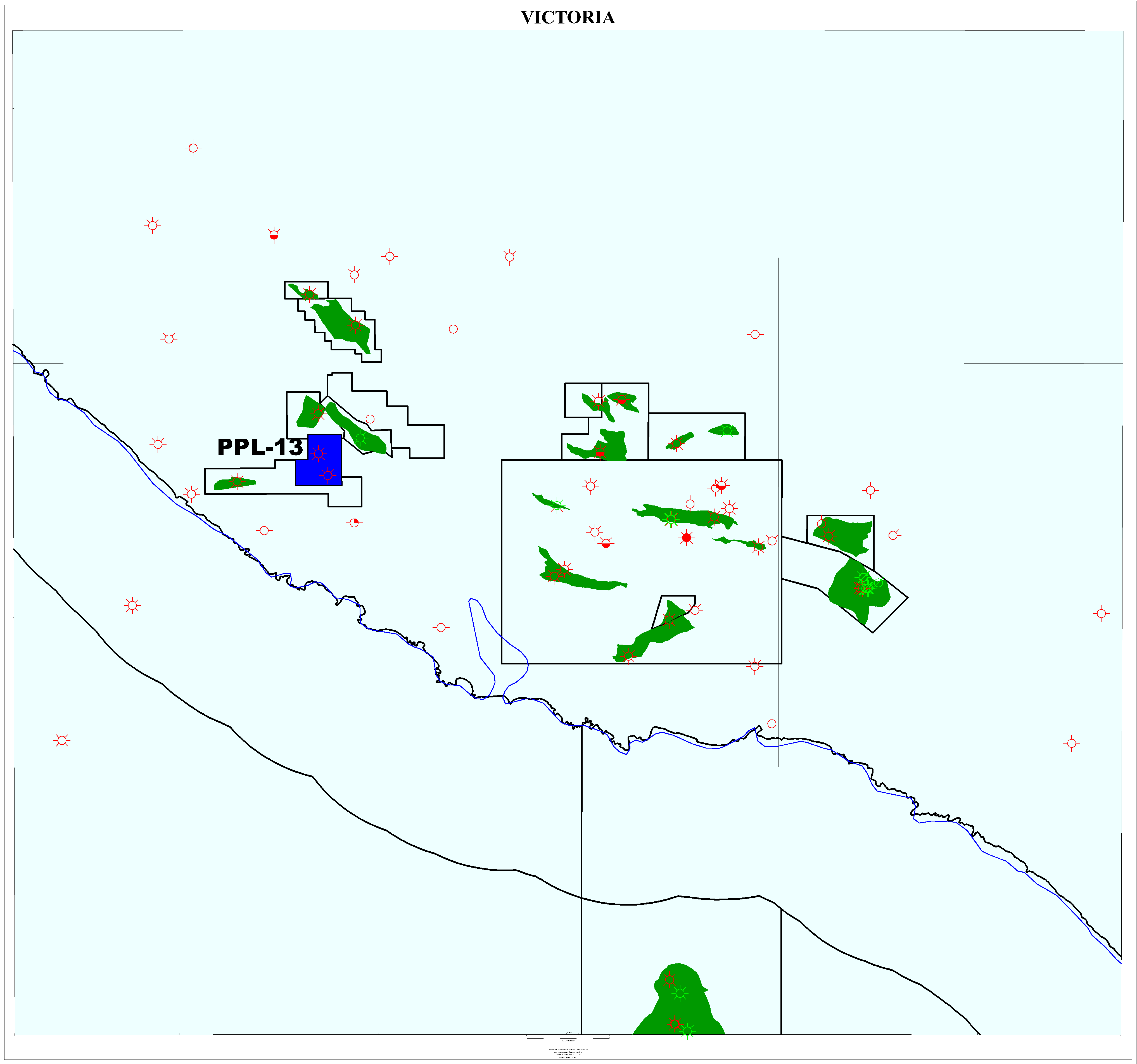
2006 038 CURRENT APPROX PERMIT AREA=2.65 Sq Km
2006 038 MIN & MAX LATITUDE = -38.540117 -38.52345
2006 038 MIN & MAX LONGITUDE = 142.79905 142.818078
HISTORICAL WELLS DRILLED UNDER (i.e. LEGALLY SPEAKING) THIS (PPL 13) TITLE NAME: WELL_NAME=CRC 1
HISTORICAL WELLS DRILLED UNDER (i.e. LEGALLY SPEAKING) THIS (PPL 13) TITLE NAME: WELL_NAME=CRC 2
ASSET ITEMS WITH *CATALOGUED* PERMIT ANCILLARY
RPT: TITLE QUARTERLY_RPT : PE801568_1 PPL13 6 Monthly Report [CD] 2006 in:PPL13 Production Licence Reports
RPT: TITLE QUARTERLY_RPT : PE911536_2 Quarterly/6Mnth Permit Reports 2005-2007[DVD] 2007 (3259 DIGITAL FILES) in:DDRs, Well & Permit Data 2005 to 2007
RPT: TITLE TITLE_RPT : PE801568 PPL13 Production Licence Reports [CD] 2006 in:Bay of COMPACTUS_1 used to store tapes
RPT: WELL DAILY_RPT : PE910003 CRC-1 Drilling, Geological & Email Rpts [CD] 2007 (132 DIGITAL FILES) in:Bay of COMPACTUS_1 used to store tapes
RPT: WELL DAILY_RPT : PE910003_1 CRC-1 Email Reports [CD] 2007 (132 DIGITAL FILES) in:CRC-1 Drilling, Geological & Email Rpts
RPT: WELL DAILY_RPT : PE910003_2 CRC-1 Daily Drilling Reports [CD] 2007 (132 DIGITAL FILES) in:CRC-1 Drilling, Geological & Email Rpts
RPT: WELL DAILY_RPT : PE910003_3 CRC-1 Geology Reports [CD] 2007 (132 DIGITAL FILES) in:CRC-1 Drilling, Geological & Email Rpts
TYP: GENERAL ESUBS_CD_DVD DDRs, Well & Permit Data 2005 to 2007 [DVD] 2007 within location: Bay of COMPACTUS_1 used to store tapes : PE911536(3259 DIGITAL FILES)
TYP: WELL WELL_LOG NAYLOR-1 Perfor Rec, HSD, Drift Run Logs[CD] 2007 within location: Bay of COMPACTUS_1 used to store tapes : PE612915(27 DIGITAL FILES)
CD : PE801568 =PPL13 Production Licence Reports PE801568_1 [TITLE QUARTERLY_RPT ] 2006 PPL13 6 Monthly Report
DRILL_RPT : PE910003 =CRC-1 Drilling, Geological & Email Rpts PE910003_1 [WELL DAILY_RPT ] 2007 CRC-1 Email Reports (132 DIGITAL FILES)
DRILL_RPT : PE910003 =CRC-1 Drilling, Geological & Email Rpts PE910003_2 [WELL DAILY_RPT ] 2007 CRC-1 Daily Drilling Reports (132 DIGITAL FILES)
DRILL_RPT : PE910003 =CRC-1 Drilling, Geological & Email Rpts PE910003_3 [WELL DAILY_RPT ] 2007 CRC-1 Geology Reports (132 DIGITAL FILES)
DVD : PE911536 =DDRs, Well & Permit Data 2005 to 2007 PE911536_2 [TITLE QUARTERLY_RPT ] 2007 Quarterly/6Mnth Permit Reports 2005-2007 (3259 DIGITAL FILES)
WARNING: THIS TITLE INFORMATION MAY BE INCOMPLETE OR OUT-OF-DATE
SDO Title area according to Oracle Spatial (Year:2006) : 2.7 SQ_KM ... Title perimeter: 7.0 km
SDO locations are based on Oracle Spatial (i.e. exact) locations.
SDO permit/title locations are based on Oracle Spatial (i.e. exact) locations.
WELLS IN GENERAL REGION -- LISTINGS BASED ON CRUDE MAX/MIN COORDINATES BOUNDING BOXES, NOT EXACT LOCATIONS OF PERMITS
HISTORICAL PERMITS IN THIS GENERAL REGION -- BASED ON CRUDE MAX/MIN COORDINATES BOUNDING BOXES, NOT EXACT LOCATIONS
FIELDS IN THIS GENERAL (BOX) REGION FIELD_NAME=NAYLOR FIELD
FIELDS IN THIS GENERAL (BOX) REGION FIELD_NAME=UNKNOWN FIELD
HISTORICAL PERMITS LIST MAY BE INCOMPLETE -- WARNING: The dbMap titles database has not had sufficient resources allocated to it to be completed.
ONshore 3D SEISMIC SURVEYS with polygons IN THIS GENERAL (SPATIAL BOX) REGION SEIS_SRVY_NAME=OCRC07 : 3D__ON
ONshore 3D SEISMIC SURVEYS with polygons IN THIS GENERAL (SPATIAL BOX) REGION SEIS_SRVY_NAME=OCV00 : 3D__ON
ONshore 3D SEISMIC SURVEYS with polygons IN THIS GENERAL (SPATIAL BOX) REGION SEIS_SRVY_NAME=ONH01 : 3D__ON
offshore 3D SEISMIC SURVEYS with polygons IN THIS GENERAL (SPATIAL BOX) REGION SEIS_SRVY_NAME=OWS03 : 3D__OFF
SDO (Oracle Spatial) functions give the spatial overlap relationships between objects.
SDO 2D SURVEYs in the PPL13 title polygon: SEIS_SRVY_NAME=OB81A : ....(SEG-Y asset link count: x 11)
SDO 2D SURVEYs in the PPL13 title polygon: SEIS_SRVY_NAME=OB81B : ....(SEG-Y asset link count: x 12)
SDO 2D SURVEYs in the PPL13 title polygon: SEIS_SRVY_NAME=OB86A : ....(SEG-Y asset link count: x 4)
SDO 2D SURVEYs in the PPL13 title polygon: SEIS_SRVY_NAME=OCRC06 : ....(SEG-Y asset link count: x 1)
SDO 2D SURVEYs in the PPL13 title polygon: SEIS_SRVY_NAME=OFBH60A
SDO 2D SURVEYs in the PPL13 title polygon: SEIS_SRVY_NAME=OFBH60C
SDO 2D SURVEYs in the PPL13 title polygon: SEIS_SRVY_NAME=OGF90B : ....(SEG-Y asset link count: x 4)
SDO CLOSE/INTERSECTING 2D 2D Lines in the PPL13 title polygon : SEIS_LINE_NAME=OB81A-115
SDO CLOSE/INTERSECTING 2D 2D Lines in the PPL13 title polygon : SEIS_LINE_NAME=OB81A-43 : ....(processed data asset links: x 2)
SDO CLOSE/INTERSECTING 2D 2D Lines in the PPL13 title polygon : SEIS_LINE_NAME=OB81B-107
SDO CLOSE/INTERSECTING 2D 2D Lines in the PPL13 title polygon : SEIS_LINE_NAME=OB81B-108
SDO CLOSE/INTERSECTING 2D 2D Lines in the PPL13 title polygon : SEIS_LINE_NAME=OB86A-3 : ....(processed data asset links: x 2)
SDO CLOSE/INTERSECTING 2D 2D Lines in the PPL13 title polygon : SEIS_LINE_NAME=OB86A-4
SDO CLOSE/INTERSECTING 2D 2D Lines in the PPL13 title polygon : SEIS_LINE_NAME=OCRC06-01 : ....(processed data asset links: x 1)
SDO CLOSE/INTERSECTING 2D 2D Lines in the PPL13 title polygon : SEIS_LINE_NAME=OFBH60A-61
SDO CLOSE/INTERSECTING 2D 2D Lines in the PPL13 title polygon : SEIS_LINE_NAME=OFBH60C-69
SDO CLOSE/INTERSECTING 2D 2D Lines in the PPL13 title polygon : SEIS_LINE_NAME=OFBH60C-71
SDO CLOSE/INTERSECTING 2D 2D Lines in the PPL13 title polygon : SEIS_LINE_NAME=OGF90B-02 : ....(processed data asset links: x 1)
SDO CLOSE/INTERSECTING 2D 2D Lines in the PPL13 title polygon : SEIS_LINE_NAME=OGF90B-08 : ....(processed data asset links: x 1)
SDO CLOSE/INTERSECTING 2D 2D Lines in the PPL13 title polygon : SEIS_LINE_NAME=OGF90B-13 : ....(processed data asset links: x 1)
SDO CLOSE/INTERSECTING 2D 2D Lines in the PPL13 title polygon : SEIS_LINE_NAME=OGF90B-15 : ....(processed data asset links: x 1)
SDO CLOSE/INTERSECTING 2D 2D Lines in the PPL13 title polygon : SEIS_LINE_NAME=OGF90B-17 : ....(processed data asset links: x 1)
SDO: HISTORICAL TITLES: 3. WITH NO OVERLAP, BUT WITHIN 15km of PPL13: TITLE_NAME=PEP108 : 4.34 km
SDO: HISTORICAL TITLES: 3. WITH NO OVERLAP, BUT WITHIN 15km of PPL13: TITLE_NAME=PEP153 : 4.34 km
SDO: HISTORICAL TITLES: 3. WITH NO OVERLAP, BUT WITHIN 15km of PPL13: TITLE_NAME=PEP169 : 4.35 km
SDO: HISTORICAL TITLES: 3. WITH NO OVERLAP, BUT WITHIN 15km of PPL13: TITLE_NAME=PEP22 : 2.88 km
SDO: HISTORICAL TITLES: 3. WITH NO OVERLAP, BUT WITHIN 15km of PPL13: TITLE_NAME=PEP6 : 1.8 km
SDO: HISTORICAL TITLES: 3. WITH NO OVERLAP, BUT WITHIN 15km of PPL13: TITLE_NAME=PEP6 : 1.96 km
SDO: HISTORICAL TITLES: 3. WITH NO OVERLAP, BUT WITHIN 15km of PPL13: TITLE_NAME=PPL1 : 5.79 km
SDO: HISTORICAL TITLES: 3. WITH NO OVERLAP, BUT WITHIN 15km of PPL13: TITLE_NAME=PPL3 : .08 km
SDO: HISTORICAL TITLES: 3. WITH NO OVERLAP, BUT WITHIN 15km of PPL13: TITLE_NAME=PPL4 : 7.97 km
SDO: HISTORICAL TITLES: 3. WITH NO OVERLAP, BUT WITHIN 15km of PPL13: TITLE_NAME=PPL5 : 11.11 km
SDO: HISTORICAL TITLES: 3. WITH NO OVERLAP, BUT WITHIN 15km of PPL13: TITLE_NAME=PPL6 : 2.72 km
SDO: HISTORICAL TITLES: 3. WITH NO OVERLAP, BUT WITHIN 15km of PPL13: TITLE_NAME=PPL7 : 8.12 km
SDO: HISTORICAL TITLES: 3. WITH NO OVERLAP, BUT WITHIN 15km of PPL13: TITLE_NAME=PPL8 : 5.8 km
SDO: HISTORICAL TITLES: 3. WITH NO OVERLAP, BUT WITHIN 15km of PPL13: TITLE_NAME=PPL9 : 4.94 km
SDO: HISTORICAL TITLES: 3. WITH NO OVERLAP, BUT WITHIN 15km of PPL13: TITLE_NAME=PRL1 : .74 km
SDO: HISTORICAL TITLES: 3. WITH NO OVERLAP, BUT WITHIN 15km of PPL13: TITLE_NAME=VIC/L30 : 14.51 km
SDO: HISTORICAL TITLES: 3. WITH NO OVERLAP, BUT WITHIN 15km of PPL13: TITLE_NAME=VIC/O-06(3) : 4.35 km
SDO: HISTORICAL TITLES: 3. WITH NO OVERLAP, BUT WITHIN 15km of PPL13: TITLE_NAME=VIC/P10 : 2.98 km
SDO: HISTORICAL TITLES: 3. WITH NO OVERLAP, BUT WITHIN 15km of PPL13: TITLE_NAME=VIC/P15 : 2.98 km
SDO: HISTORICAL TITLES: 3. WITH NO OVERLAP, BUT WITHIN 15km of PPL13: TITLE_NAME=VIC/P30 : 8.75 km
SDO: HISTORICAL TITLES: 3. WITH NO OVERLAP, BUT WITHIN 15km of PPL13: TITLE_NAME=VIC/P31 : 8.97 km
SDO: HISTORICAL TITLES: 3. WITH NO OVERLAP, BUT WITHIN 15km of PPL13: TITLE_NAME=VIC/P37(V) : 2.87 km
SDO: HISTORICAL TITLES: 3. WITH NO OVERLAP, BUT WITHIN 15km of PPL13: TITLE_NAME=VIC/P38(V) : 12.25 km
SDO: HISTORICAL TITLES: 3. WITH NO OVERLAP, BUT WITHIN 15km of PPL13: TITLE_NAME=VIC/P44 : 8.65 km
SDO: HISTORICAL TITLES: 3. WITH NO OVERLAP, BUT WITHIN 15km of PPL13: TITLE_NAME=VIC/P44 : 8.7 km
SDO: HISTORICAL TITLES: 3. WITH NO OVERLAP, BUT WITHIN 15km of PPL13: TITLE_NAME=VIC/RL2(v) : 4.17 km
SDO: HISTORICAL WELLS: 1. ENCLOSED WITHIN PPL13 POLYGON(S): WELL_NAME=CRC-1 : 15-MAR-07, CO2CRC (ON SHORE))
SDO: HISTORICAL WELLS: 1. ENCLOSED WITHIN PPL13 POLYGON(S): WELL_NAME=CRC-2 : 17-FEB-10, CO2CRC (ON SHORE))
SDO: HISTORICAL WELLS: 1. ENCLOSED WITHIN PPL13 POLYGON(S): WELL_NAME=NAYLOR SOUTH-1 : 30-DEC-01, Santos Ltd (ON SHORE))
SDO: HISTORICAL WELLS: 1. ENCLOSED WITHIN PPL13 POLYGON(S): WELL_NAME=NAYLOR-1 : 19-MAY-01, Santos Ltd (ON SHORE))
SDO: HISTORICAL WELLS: 2. NEAR PPL13 POLYGON(S): WELL_NAME=AYRFORD-1 : DISTANCE = 5.89 km (20-APR-08, Essential Petroleum Resources Ltd (ON SHORE))
SDO: HISTORICAL WELLS: 2. NEAR PPL13 POLYGON(S): WELL_NAME=BARTON CORNER-1 : DISTANCE = 11.11 km (20-APR-85, Beach Petroleum NL (ON SHORE))
SDO: HISTORICAL WELLS: 2. NEAR PPL13 POLYGON(S): WELL_NAME=BLACKWOOD-1 : DISTANCE = 12.54 km (15-MAY-96, Cultus Petroleum N.L. (ON SHORE))
SDO: HISTORICAL WELLS: 2. NEAR PPL13 POLYGON(S): WELL_NAME=BOGGY CREEK-1 : DISTANCE = .56 km (12-JAN-92, Gas & Fuel Exploration NL (ON SHORE))
SDO: HISTORICAL WELLS: 2. NEAR PPL13 POLYGON(S): WELL_NAME=BRAESIDE-1 : DISTANCE = 13.43 km (24-APR-82, Beach Petroleum NL (ON SHORE))
SDO: HISTORICAL WELLS: 2. NEAR PPL13 POLYGON(S): WELL_NAME=BUTTRESS-1 : DISTANCE = .75 km (19-JAN-02, Santos P/L (ON SHORE))
SDO: HISTORICAL WELLS: 2. NEAR PPL13 POLYGON(S): WELL_NAME=CALLAGHAN-1 : DISTANCE = 1.63 km (, Essential Petroleum Resources Ltd (ON SHORE))
SDO: HISTORICAL WELLS: 2. NEAR PPL13 POLYGON(S): WELL_NAME=CALLISTA-1 : DISTANCE = 6.52 km (07-APR-88, Beach Petroleum NL (ON SHORE))
SDO: HISTORICAL WELLS: 2. NEAR PPL13 POLYGON(S): WELL_NAME=CHILDERS COVE-1 : DISTANCE = 6.12 km (06-OCT-05, Origin Energy Resources Limited (ON SHORE))
SDO: HISTORICAL WELLS: 2. NEAR PPL13 POLYGON(S): WELL_NAME=CROFT-1 : DISTANCE = 2.13 km (20-APR-01, Santos Ltd (ON SHORE))
SDO: HISTORICAL WELLS: 2. NEAR PPL13 POLYGON(S): WELL_NAME=CURDIE-1 : DISTANCE = 1.57 km (28-MAR-82, Beach Petroleum NL (ON SHORE))
SDO: HISTORICAL WELLS: 2. NEAR PPL13 POLYGON(S): WELL_NAME=CURDIEVALE-1 : DISTANCE = 2.21 km (27-MAR-83, Beach Petroleum NL (ON SHORE))
SDO: HISTORICAL WELLS: 2. NEAR PPL13 POLYGON(S): WELL_NAME=CUSTER-1 : DISTANCE = 5.37 km (, (ON SHORE))
SDO: HISTORICAL WELLS: 2. NEAR PPL13 POLYGON(S): WELL_NAME=DUNBAR EAST-1 : DISTANCE = 9.73 km (21-APR-96, Cultus Petroleum N.L. (ON SHORE))
SDO: HISTORICAL WELLS: 2. NEAR PPL13 POLYGON(S): WELL_NAME=DUNBAR-1 : DISTANCE = 7.84 km (01-APR-95, GFE Resources Limited (ON SHORE))
SDO: HISTORICAL WELLS: 2. NEAR PPL13 POLYGON(S): WELL_NAME=DUNBAR-1 DW 1 : DISTANCE = 7.84 km (26-MAR-01, Origin Energy Resources Limited (ON SHORE))
SDO: HISTORICAL WELLS: 2. NEAR PPL13 POLYGON(S): WELL_NAME=EAST WING-1 : DISTANCE = 1.65 km (03-JUN-08, Essential Petroleum Resources Ltd (ON SHORE))
SDO: HISTORICAL WELLS: 2. NEAR PPL13 POLYGON(S): WELL_NAME=EAST WING-1 ST : DISTANCE = 1.65 km (03-JUN-08, Essential Petroleum Resources Ltd (ON SHORE))
SDO: HISTORICAL WELLS: 2. NEAR PPL13 POLYGON(S): WELL_NAME=FENTON CREEK-1 : DISTANCE = 10.1 km (11-APR-97, SANTOS Limited ACN007550923 (ON SHORE))
SDO: HISTORICAL WELLS: 2. NEAR PPL13 POLYGON(S): WELL_NAME=FLAXMANS-1 : DISTANCE = 3.93 km (08-NOV-61, Frome-Broken Hill Company Proprietary Limited (ON SHORE))
SDO: HISTORICAL WELLS: 2. NEAR PPL13 POLYGON(S): WELL_NAME=GRUMBY-1 : DISTANCE = 12.79 km (14-MAR-81, Beach Petroleum NL (ON SHORE))
SDO: HISTORICAL WELLS: 2. NEAR PPL13 POLYGON(S): WELL_NAME=HALLADALE-1 DW1 : DISTANCE = 7.36 km (02-MAY-05, Origin Energy Resources Limited (OFF SHORE / MARINE))
SDO: HISTORICAL WELLS: 2. NEAR PPL13 POLYGON(S): WELL_NAME=HALLADALE-1 DW2 : DISTANCE = 7.36 km (02-MAY-05, Origin Energy Resources Limited (OFF SHORE / MARINE))
SDO: HISTORICAL WELLS: 2. NEAR PPL13 POLYGON(S): WELL_NAME=HALLADALE-1 DW3 : DISTANCE = 7.36 km (02-MAY-05, Origin Energy Resources Limited (OFF SHORE / MARINE))
SDO: HISTORICAL WELLS: 2. NEAR PPL13 POLYGON(S): WELL_NAME=HOWMAINS-1 : DISTANCE = 5.13 km (22-JUL-94, GFE Resources Limited (ON SHORE))
SDO: HISTORICAL WELLS: 2. NEAR PPL13 POLYGON(S): WELL_NAME=LANGLEY-1 : DISTANCE = 12.1 km (09-JUN-94, GFE Resources Limited (ON SHORE))
SDO: HISTORICAL WELLS: 2. NEAR PPL13 POLYGON(S): WELL_NAME=LAVERS-1 : DISTANCE = 5.1 km (05-MAY-01, Santos Ltd (ON SHORE))
SDO: HISTORICAL WELLS: 2. NEAR PPL13 POLYGON(S): WELL_NAME=MARTHA-1 : DISTANCE = 12.56 km (05-NOV-04, Essential Petroleum Resources Ltd (OFF SHORE / MARINE))
SDO: HISTORICAL WELLS: 2. NEAR PPL13 POLYGON(S): WELL_NAME=MCINTEE-1 : DISTANCE = 4.01 km (23-FEB-01, Santos Ltd (ON SHORE))
SDO: HISTORICAL WELLS: 2. NEAR PPL13 POLYGON(S): WELL_NAME=MELBA-1 : DISTANCE = 5.82 km (31-MAR-03, Santos Ltd (ON SHORE))
SDO: HISTORICAL WELLS: 2. NEAR PPL13 POLYGON(S): WELL_NAME=MYLOR-1 : DISTANCE = 9.25 km (28-JUN-94, Bridge Oil Ltd (ON SHORE))
SDO: HISTORICAL WELLS: 2. NEAR PPL13 POLYGON(S): WELL_NAME=NARINGAL-1 : DISTANCE = 9.46 km (02-FEB-02, Santos Ltd (ON SHORE))
SDO: HISTORICAL WELLS: 2. NEAR PPL13 POLYGON(S): WELL_NAME=NORTH PAARATTE-1 : DISTANCE = 11.92 km (29-NOV-79, Beach Petroleum NL (ON SHORE))
SDO: HISTORICAL WELLS: 2. NEAR PPL13 POLYGON(S): WELL_NAME=NORTH PAARATTE-2 : DISTANCE = 13.45 km (15-FEB-81, Beach Petroleum NL (ON SHORE))
SDO: HISTORICAL WELLS: 2. NEAR PPL13 POLYGON(S): WELL_NAME=NORTH PAARATTE-4 : DISTANCE = 11.99 km (11-APR-99, Boral Energy Petroleum Pty Limited (ON SHORE))
SDO: HISTORICAL WELLS: 2. NEAR PPL13 POLYGON(S): WELL_NAME=NORTH PAARATTE-5 : DISTANCE = 12 km (30-MAR-99, Boral Energy Petroleum Pty Limited (ON SHORE))
SDO: HISTORICAL WELLS: 2. NEAR PPL13 POLYGON(S): WELL_NAME=PECTEN EAST-1 : DISTANCE = 13.9 km (14-JUL-08, SANTOS Limited ACN007550923 (OFF SHORE / MARINE))
SDO: HISTORICAL WELLS: 2. NEAR PPL13 POLYGON(S): WELL_NAME=PENRYN-1 : DISTANCE = 12.02 km (20-JAN-00, SANTOS Limited ACN007550923 (ON SHORE))
SDO: HISTORICAL WELLS: 2. NEAR PPL13 POLYGON(S): WELL_NAME=PENRYN-2 : DISTANCE = 13.97 km (17-AUG-01, SANTOS Limited ACN007550923 (ON SHORE))
SDO: HISTORICAL WELLS: 2. NEAR PPL13 POLYGON(S): WELL_NAME=PETERBOROUGH-1 : DISTANCE = 6.3 km (10-SEP-05, Origin Energy Resources Limited (ON SHORE))
SDO: HISTORICAL WELLS: 2. NEAR PPL13 POLYGON(S): WELL_NAME=PETERBOROUGH-1 ST1 : DISTANCE = 6.3 km (10-SEP-05, Origin Energy Resources Limited (ON SHORE))
SDO: HISTORICAL WELLS: 2. NEAR PPL13 POLYGON(S): WELL_NAME=PORT CAMPBELL-1 : DISTANCE = 13.53 km (16-FEB-60, Frome-Broken Hill Company Proprietary Limited (ON SHORE))
SDO: HISTORICAL WELLS: 2. NEAR PPL13 POLYGON(S): WELL_NAME=PORT CAMPBELL-3 : DISTANCE = 9.25 km (13-MAR-61, Frome-Broken Hill Company Proprietary Limited (ON SHORE))
SDO: HISTORICAL WELLS: 2. NEAR PPL13 POLYGON(S): WELL_NAME=PORT CAMPBELL-4 : DISTANCE = 13.65 km (26-AUG-64, Frome-Broken Hill Company Proprietary Limited (ON SHORE))
SDO: HISTORICAL WELLS: 2. NEAR PPL13 POLYGON(S): WELL_NAME=ROWANS-1 : DISTANCE = 7.22 km (05-MAY-72, Shell Development (Australia) Proprietary Limited (ON SHORE))
SDO: HISTORICAL WELLS: 2. NEAR PPL13 POLYGON(S): WELL_NAME=SCHOMBERG-1 : DISTANCE = 1 km (, Gas and Fuel Exploration NL (ON SHORE))
SDO: HISTORICAL WELLS: 2. NEAR PPL13 POLYGON(S): WELL_NAME=SKULL CREEK WEST-1 : DISTANCE = 12.55 km (02-MAR-97, Cultus Petroleum N.L. (ON SHORE))
SDO: HISTORICAL WELLS: 2. NEAR PPL13 POLYGON(S): WELL_NAME=TREGONY-1 : DISTANCE = 9.39 km (15-MAR-01, Santos Ltd (ON SHORE))
SDO: HISTORICAL WELLS: 2. NEAR PPL13 POLYGON(S): WELL_NAME=VAUGHAN-1 : DISTANCE = 8.9 km (06-MAR-95, GFE Resources Limited (ON SHORE))
SDO: HISTORICAL WELLS: 2. NEAR PPL13 POLYGON(S): WELL_NAME=WALLABY CREEK-1 : DISTANCE = 8.34 km (01-APR-81, Beach Petroleum NL (ON SHORE))
SDO: HISTORICAL WELLS: 2. NEAR PPL13 POLYGON(S): WELL_NAME=WALLABY CREEK-2 : DISTANCE = 8.58 km (04-MAY-95, GFE Resources Limited (ON SHORE))
SDO: HISTORICAL WELLS: 2. NEAR PPL13 POLYGON(S): WELL_NAME=WESTGATE-1 : DISTANCE = 8.67 km (24-MAR-86, Beach Petroleum NL (ON SHORE))
SDO: HISTORICAL WELLS: 2. NEAR PPL13 POLYGON(S): WELL_NAME=WESTGATE-1A : DISTANCE = 8.67 km (24-MAR-86, Beach Petroleum NL (ON SHORE))
SDO: HISTORICAL WELLS: 2. NEAR PPL13 POLYGON(S): WELL_NAME=WILD DOG ROAD-1 : DISTANCE = 14.07 km (18-DEC-99, Origin Energy Resources Limited (ON SHORE))
Title outline: PPL13 2006_038 00001 1 -38.52345 142.804189 COORD_SYS_ID=218 STATUS=CURRENT Term: 07-FEB-06 to 31-DEC-99 Vrsn: 07-FEB-06 to 31-DEC-99
Title outline: PPL13 2006_038 00002 2 -38.52345 142.818078 COORD_SYS_ID=218 STATUS=CURRENT Term: 07-FEB-06 to 31-DEC-99 Vrsn: 07-FEB-06 to 31-DEC-99
Title outline: PPL13 2006_038 00003 3 -38.537339 142.818078 COORD_SYS_ID=218 STATUS=CURRENT Term: 07-FEB-06 to 31-DEC-99 Vrsn: 07-FEB-06 to 31-DEC-99
Title outline: PPL13 2006_038 00004 4 -38.540117 142.818078 COORD_SYS_ID=218 STATUS=CURRENT Term: 07-FEB-06 to 31-DEC-99 Vrsn: 07-FEB-06 to 31-DEC-99
Title outline: PPL13 2006_038 00005 5 -38.540117 142.79905 COORD_SYS_ID=218 STATUS=CURRENT Term: 07-FEB-06 to 31-DEC-99 Vrsn: 07-FEB-06 to 31-DEC-99
Title outline: PPL13 2006_038 00006 6 -38.531783 142.79905 COORD_SYS_ID=218 STATUS=CURRENT Term: 07-FEB-06 to 31-DEC-99 Vrsn: 07-FEB-06 to 31-DEC-99
Title outline: PPL13 2006_038 00007 7 -38.531783 142.804189 COORD_SYS_ID=218 STATUS=CURRENT Term: 07-FEB-06 to 31-DEC-99 Vrsn: 07-FEB-06 to 31-DEC-99
Title outline: PPL13 2006_038 00008 8 -38.52345 142.804189 COORD_SYS_ID=218 STATUS=CURRENT Term: 07-FEB-06 to 31-DEC-99 Vrsn: 07-FEB-06 to 31-DEC-99
LINKS HYPERLINKAGESPERMIT_BOX_ASSETSABOUT_DBMAPHOW_TO_GET_OR_SUBMIT_DATACOPYRIGHT_DISCLAIMER
LINKS OTWAY_TITLESMURRAY_TITLESHISTORICAL_TITLESMODERN_PERMIT_MAP
LINKS PERMIT_BOXES_SORTED_BY_PERMITPERMIT_BOX_ASSETSALL_TITLESGIPPSLAND_TITLES

 Petrosys Mapping POLYGON data file in GDA94 : ../peimages/ppl13_gda94.ply
(Image) file: ppl13.png
Petrosys Mapping POLYGON data file in GDA94 : ../peimages/ppl13_gda94.ply
(Image) file: ppl13.png