Geological Survey of Victoria
Earth Resources Policy and Programs
:
dbMap DATABASE DUMP
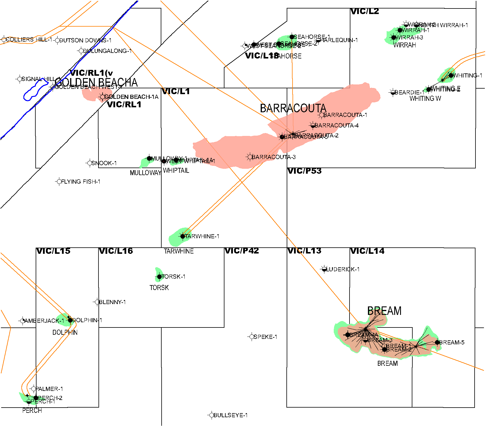
DOLPHINFIELD
(Image) file: dolphinfield.png
*** DOLPHINFIELD ***
dolphinfield 000 LINKS
HYPERLINKAGES
PERMIT_BOX_ASSETS
ABOUT_DBMAP
HOW_TO_GET_OR_SUBMIT_DATA
COPYRIGHT_DISCLAIMER
ORIGINAL WELL TITLE_NAME=
VIC/L15
ORIGINAL WELL TITLE_NAME=
VIC/L15
& 16 ORIGINAL WELL TITLE_NAME=
VIC/P1
WELLS WITH THIS FIELD: WELL_NAME=
DOLPHIN-1
WELLS WITH THIS FIELD: WELL_NAME=
DOLPHIN-2
WELLS WITH THIS FIELD: WELL_NAME=
DOLPHIN-A3
LINKS FIELD ASSETS - GIPPSLAND OFFSHORE FIELDS =
XSLF051
LINKS FIELD ASSETS - GIPPSLAND ON SHORE FIELDS =
XSLF053
LINKS FIELD ASSETS - OTHER FIELDS =
XSLF055
LINKS FIELD ASSETS - OTWAY OFFSHORE FIELDS =
XSLF052
LINKS FIELD ASSETS - OTWAY ON SHORE FIELDS =
XSLF054
LINKS FIELD BOX ASSETS sorted by location name =
XSLF043
LINKS FIELD BOXES AND WELL ASSIGNED FIELDS =
XSLF042
LINKS FIELD LIST =
XSLF056
LINKS
FIELD_BOXES_SORTED_BY_PERMIT
LINKS
FIELD_BOX_ASSETS
( 0.7m ) LINKS LINKAGES TO FIELDS =
XSLF042
FIELD SIZE= NAME=DOLPHIN A AVE_WATER_DEPTH = -38 FIELD SIZE= NAME=DOLPHIN A BASIN = GIPPSLAND FIELD SIZE= NAME=DOLPHIN A CONSTRUCTION = STEEL GRAVITY BASED MONOTOWER FIELD SIZE= NAME=DOLPHIN A COORD_TYPE = UNKNOWN FIELD SIZE= NAME=DOLPHIN A DISCOVERY_DATE = 31-OCT-67 FIELD SIZE= NAME=DOLPHIN A FIELD_NAME = DOLPHIN FIELD SIZE= NAME=DOLPHIN A FIELD_SIZE_Ha = 220 FIELD SIZE= NAME=DOLPHIN A G_FACTOR = 1.1424 FIELD SIZE= NAME=DOLPHIN A LONG_NAME = DOLPHIN A FIELD SIZE= NAME=DOLPHIN A ONSHORE_IND = N FIELD SIZE= NAME=DOLPHIN A OPERATOR = ESSO FIELD SIZE= NAME=DOLPHIN A O_FACTOR = 1.12 FIELD SIZE= NAME=DOLPHIN A PRIMARY_TITLE_NAME =
VIC/L15
FIELD SIZE= NAME=DOLPHIN A PRODUCTION_START = 31-JAN-90 FIELD SIZE= NAME=DOLPHIN A PRODUCTS = OIL FIELD SIZE= NAME=DOLPHIN A SHORT_NAME = DPA FIELD SIZE= NAME=DOLPHIN A W_FACTOR = 1.03
BOX: TITLE FIELD_BOX
PE180849
Dolphin Field Box 1 of 1 [CARDBOARD_BO] (?2000) 1 Dolphin Field Box 1 of 1
RPT: TITLE REGIONAL_RPT
PE910667
Southwest Gippsland Reservoir Study [PAPER] (?1989) 1
PE910667__((_SOUTHWEST_GIPPSLAND_RESERVOIR_STUDY_))_.TIF(7.6m).........
Southwest Gippsland Reservoir Study, Esso Australia Ltd, Production Dept. Contains Dolphin, Tarwhine and Perch. RPT: WELL RPT
PE804803
Compilation of Maps.Perch-Dolphin-SthTar[PAPER] (?2000) 1
PE804803__((_COMPILATION_OF_MAPS.PERCH-DOLPHIN-STHTAR_))_.TIF(0.2m).........
Compilation of Maps. Perch - Dolphin - South Tarwhine Fields. Esso Exploration and Production Australia Inc. Compiled by DNRE, Dec, 2000. RPT: WELL RPT
PE804987
DOLPHIN-1 Geol.Modelling.Dolphin Fld.C1.[PAPER] (?1993) 1
(9 DIGITAL FILES)
Geological Modelling, Reservoir Description and Volumetric Assessment. DOLPHIN-1 Field. Copy 1. Esso Australia Limited. Author: A.J.McKerron, Aug, 1993. RPT: WELL RPT
PE804992
DOLPHIN-1 Dolphin Assess.TOL Gp N-1 Res.[PAPER] (?1990) 1
PE804992__((_DOLPHIN-1_DOLPHIN_ASSESS.TOL_GP_N-1_RES._))_.TIF(0.6m).........
DOLPHIN-1 Assessments. Top of Latrobe Group N-1 Reservoir. Esso Australia Ltd. Author: M.C.Galloway, Feb, 1990.
GENERAL DNRE_COMPILATION
PE804890
Compilation of Maps.Perch-Palmer-Dolph-T[PAPER] (?2000) 1
PE804890__((_COMPILATION_OF_MAPS.PERCH-PALMER-DOLPH-T_))_.TIF(0.3m).........
Compilation of Maps for the Palmer-Perch Fields and Perch-Dolphin-Tarwhine Fields. Compiled by DNRE, Dec, 2000. GENERAL DNRE_COMPILATION
PE805316
Perch & Dolphin Data Package.Compilation[PAPER] (?2000) 1
PE805316__((_PERCH___DOLPHIN_DATA_PACKAGE.COMPILATION_))_.TIF(1.9m).........
Perch & Dolphin Data Package. Esso Australia Ltd (1988). Compiled by DNRE, Dec, 2000. GENERAL OBSOLETE_DESTROYED
PE804982
Destroyed-Geological Modelling. [PAPER] (?1993) 1 Destroyed - Geological Modelling, Reservoir Description and Volumetric Assessment. Dolphin Field. Copy 2. Esso Australia Limited. Author: A.J.McKerron, Aug, 1993. GENERAL OBSOLETE_DESTROYED
PE804983
Destroyed-Stratigraphic Cross-Sect'n [PAPER] (?1993) 1 Destroyed - Dolphin Field Stratigraphic Cross-Section. Scale 1:200. Esso. Author: A.J.McKerron, June, 1993. (Enclosure 1 from: Geological Modelling, Reservoir Description and Volumetric Assessment. Dolphin Field. Esso). GENERAL OBSOLETE_DESTROYED
PE804984
Destroyed-Field RFT Analysis. [PAPER] (?1993) 1 Destroyed - DOLPHIN-1 and DOLPHIN-2 Field RFT Analysis. Esso. Author: A.J.McKerron, June, 1993. (Enclosure 2 from: Geological Modelling, Reservoir Description and Volumetric Assessment. Dolphin Field. Esso). GENERAL OBSOLETE_DESTROYED
PE804985
Destroyed-Map, N1.1. Dolphin Field. [PAPER] (?1993) 1 Destroyed - Top Porosity Map, N1.1. Dolphin Field. Esso. Author: A.J.McKerron, June, 1993. (Enclosure 3 from: Geological Modelling, Reservoir Description and Volumetric Assessment. Dolphin Field. Esso). GENERAL OBSOLETE_DESTROYED
PE804986
Destroyed-Volume Model Cross-Section. [PAPER] (?1993) 1 Destroyed - DOLPHIN-1 Volume Model Cross-Section (A-B). Esso. Author: A.J.McKerron, Sep, 1993. (Enclosure 4 from: Geological Modelling, Reservoir Description and Volumetric Assessment. Dolphin Field. Esso). GENERAL REGISTRY_FILE
F3006187
VIC/L15 & / 1 Registry File [PAPER] (?1996) 1 VIC/L15 & part1 PRODUCTION LICENCE FOR PETROLEUM BHP PETROLEUM PTY LTD : DOLPHIN FIELD GENERAL REGISTRY_FILE
F3025076
PE/18/0016 Registry File [PAPER] (?1997) 1 PE/18/0016 PETROLEUM FIELD - ALL BUT PRODUCTION RETURNS PRODUCTION LICENCE FOR PETROLEUM - VIC/L15 & 16 DOLPHIN FIELD - STRUCTURE ASSESSMENT GENERAL REGISTRY_FILE
F3025515
PE/14/0005 Registry File [PAPER] (?1997) 1 PE/14/0005 PETROLEUM FIELD - PRODUCTION RETURNS PRODUCTION LICENCE FOR PETROLEUM - VIC/L15 & 16 DOLPHIN FIELD - ESSO AUSTRALIA LTD SEISMIC HRZN_CONTR_MAP
PE804799
Depth Structure Map. Top of Latrobe Gp. [PAPER] (?1979) 1
PE804799__((_DEPTH_STRUCTURE_MAP._TOP_OF_LATROBE_GP._))_.TIF(2.1m).........
Depth Structure Map. Top of Latrobe Gp. Scale: 1:25,000. Perch-Dolphin-SthTarwhine Fields.Esso. Author: B.J.Phillips, May, 1979.(Enclosure from: Compilation of Maps. Perch-Dolphin-South Tarwhine Fields.Esso. Compiled by DNRE,2000). SEISMIC HRZN_CONTR_MAP
PE805306
Structure Map. Lower N.Asperus Marker. [PAPER] (?1976) 1
PE805306__((_STRUCTURE_MAP._LOWER_N.ASPERUS_MARKER._))_.TIF(0.5m).........
Structure Map. Lower N.Asperus Marker. Perch-Dolphin-Tarwhine Area. Scale: 1:50,000. Esso. Author: R.J.Steele, Jan, 1976. (Enclosure from: Compilation of Maps for the Palmer-Perch & Perch-Dolphin-Tarwhine Fields. DNRE, Dec, 2000). SEISMIC HRZN_CONTR_MAP
PE805307
Structure Map. Top of Latrobe Group-C.C [PAPER] (?1976) 1
PE805307__((_STRUCTURE_MAP._TOP_OF_LATROBE_GROUP-C.C_))_.TIF(0.3m).........
Structure Map (Preliminary). Top of Latrobe Gp-Coarse Clastics. Perch-Dolphin-Tarwhine Area.Scale: 1:50,000.Esso, R.J.Steele, Jan,1976. (Enclosure from: Compilation of Maps for the Perch-Dolphin-Tarwhine Fields. DNRE, Dec, 2000). SEISMIC HRZN_CONTR_MAP
PE805318
Structure Map. Top of C.Clastics.Dolphin[PAPER] (?1985) 1
PE805318__((_STRUCTURE_MAP._TOP_OF_C.CLASTICS.DOLPHIN_))_.TIF(0.2m).........
Structure Map. Top of Coarse Clastics (most likely case). Dolphin Discovery. Scale: 1:25,000. Esso. Author: D.Spring, Nov, 1985. (Enclosure from: Perch & Dolphin Data Package. Esso Australia Ltd (1988). Compiled by DNRE, Dec, 2000). SEISMIC ISOCHRON_MAP
PE804798
Time Structure Map. Top of Latrobe Group[PAPER] (?1979) 1
PE804798__((_TIME_STRUCTURE_MAP._TOP_OF_LATROBE_GROUP_))_.TIF(0.5m).........
Time Structure Map. Top of Latrobe Group. Scale: 1:25,000. Perch-Dolphin-SthTarwhine Fields. Esso. Author: B.J.Phillips, May, 1979. (Enclosure from: Compilation of Maps.Perch-Dolphin-South Tarwhine Fields.Esso.Compiled by DNRE,2000). SEISMIC ISOCHRON_MAP
PE804894
Time Structure Map. Top of Latrobe Group[PAPER] (?1976) 1
PE804894__((_TIME_STRUCTURE_MAP._TOP_OF_LATROBE_GROUP_))_.TIF(0.3m).........
Time Structure Map (Prelim.). Top of Latrobe Group-Coarse Clastics. Perch-Dolphin-Tarwhine Area.Esso. Author:R.J.Steele, Jan, 1976. (Enclosure from: Compilation of Maps for the Palmer-Perch & Perch-Dolphin-Tarwhine Fields. DNRE, Dec, 2000). SEISMIC ISOCHRON_MAP
PE804895
Isochron Map. U.Miocene to Latrobe-C.C's[PAPER] (?1976) 1
PE804895__((_ISOCHRON_MAP._U.MIOCENE_TO_LATROBE-C.C_S_))_.TIF(0.3m).........
Isochron Map (Prelim.). Upper Miocene to Latrobe-Coarse Clastics. Perch-Dolphin-Tarwhine Area.Esso. Author: R.J.Steele, Jan, 1976. (Enclosure from: Compilation of Maps for the Palmer-Perch & Perch-Dolphin-Tarwhine Fields. DNRE, Dec, 2000). SEISMIC ISOCHRON_MAP
PE804999
Time Structure Map. Lower N.Asperus Mark[PAPER] (?1976) 1
PE804999__((_TIME_STRUCTURE_MAP._LOWER_N.ASPERUS_MARK_))_.TIF(0.3m).........
Time Structure Map. Lower N.Asperus Marker. Perch-Dolphin-Tarwhine Area.Scale: 1:50,000. Esso. Author: R.J.Steele, Jan, 1976. (Enclosure from: Compilation of Maps for the Palmer-Perch & Perch-Dolphin-Tarwhine Fields. DNRE, Dec, 2000). SEISMIC ISOCHRON_MAP
PE805308
Time Structure Map.A Mid Miocene Marker.[PAPER] (?1976) 1
PE805308__((_TIME_STRUCTURE_MAP.A_MID_MIOCENE_MARKER._))_.TIF(0.2m).........
Time Structure Map. A Mid Miocene Marker (Preliminary). Perch-Dolphin-Tarwhine Area. Scale: 1:50,000.Esso, R.J.Steele, Jan,1976. (Enclosure from: Compilation of Maps for the Perch-Dolphin-Tarwhine Fields. DNRE, Dec, 2000). SEISMIC ISOCHRON_MAP
PE805309
Time Structure Map.Upper Miocene Marker.[PAPER] (?1976) 1
PE805309__((_TIME_STRUCTURE_MAP.UPPER_MIOCENE_MARKER._))_.TIF(0.2m).........
Time Structure Map. An Upper Miocene Marker (Preliminary). Perch-Dolphin-Tarwhine Area. Scale: 1:50,000.Esso, R.J.Steele, Jan,1976. (Enclosure from: Compilation of Maps for the Perch-Dolphin-Tarwhine Fields. DNRE, Dec, 2000). SEISMIC ISOPACH_MAP
PE804794
Isopach Map. Strat. Top, N-1.2. [PAPER] (?1990) 1
PE804794__((_ISOPACH_MAP._STRAT._TOP,_N-1.2._))_.TIF(0.1m).........
Isopach Map. Stratigraphic Top, N-1.2 Reservoir. Esso Australia Ltd. Author: M.C.Galloway, Sep, 1990. (Figure 8 from: Dolphin Assessments. Top of Latrobe Group N-1 Reservoir. Author: M.C.Galloway, Feb, 1990). SEISMIC ISOPACH_MAP
PE804795
Isopach Map. Net Oil Sand, N-1.2. [PAPER] (?1990) 1
PE804795__((_ISOPACH_MAP._NET_OIL_SAND,_N-1.2._))_.TIF(0.1m).........
Isopach Map. Net Oil Sand, N-1.2 Reservoir. Esso Australia Ltd. Author: M.C.Galloway, Sep, 1990. (Figure 9 from: Dolphin Assessments. Top of Latrobe Group N-1 Reservoir. Author: M.C.Galloway, Feb, 1990). SEISMIC ISOPACH_MAP
PE804796
Isopach Map. Strat. Top, N-1.3. [PAPER] (?1990) 1
PE804796__((_ISOPACH_MAP._STRAT._TOP,_N-1.3._))_.TIF(0.1m).........
Isopach Map. Stratigraphic Top, N-1.3 Reservoir. Esso Australia Ltd. Author: M.C.Galloway, Sep, 1990. (Figure 10 from: Dolphin Assessments. Top of Latrobe Group N-1 Reservoir. Author: M.C.Galloway, Feb, 1990). SEISMIC ISOPACH_MAP
PE804797
Isopach Map. Net Oil, N-1.3. [PAPER] (?1990) 1
PE804797__((_ISOPACH_MAP._NET_OIL,_N-1.3._))_.TIF(0.1m).........
Isopach Map. Net Oil, N-1.3 Reservoir. Esso Australia Ltd. Author: M.C.Galloway, Sep, 1990. (Figure 11 from: Dolphin Assessments. Top of Latrobe Group N-1 Reservoir. Author: M.C.Galloway, Feb, 1990). SEISMIC ISOPACH_MAP
PE804802
Depth to Top Coarse Clastics.Dolphin Fd.[PAPER] (?1983) 1
PE804802__((_DEPTH_TO_TOP_COARSE_CLASTICS.DOLPHIN_FD._))_.TIF(1.1m).........
Depth to Top of Coarse Clastics (most likely case). Dolphin Prospect. Vertical Scale: 1:250. Esso. Authors: A.R.Hoare, Nov, 1983. (Enclosure from: Compilation of Maps. Perch-Dolphin-South Tarwhine Fields. Esso. Compiled by DNRE, 2000). SEISMIC ISOPACH_MAP
PE804993
Isopach Map. Stratigraphic Top, N-1.1. [PAPER] (?1990) 1
PE804993__((_ISOPACH_MAP._STRATIGRAPHIC_TOP,_N-1.1._))_.TIF(0.1m).........
Isopach Map. Stratigraphic Top, N-1.1 Reservoir. Esso Australia Ltd. Author: M.C.Galloway, Sep, 1990. (Figure 3 from: Dolphin Assessments. Top of Latrobe Group N-1 Reservoir. Author: M.C.Galloway, Feb, 1990). SEISMIC ISOPACH_MAP
PE804994
Isopach Map. Porosity Top, N-1.1. [PAPER] (?1990) 1
PE804994__((_ISOPACH_MAP._POROSITY_TOP,_N-1.1._))_.TIF(0.2m).........
Isopach Map. Porosity Top, N-1.1 Reservoir. Esso Australia Ltd. Author: M.C.Galloway, Sep, 1990. (Figure 4 from: Dolphin Assessments. Top of Latrobe Group N-1 Reservoir. Author: M.C.Galloway, Feb, 1990). SEISMIC ISOPACH_MAP
PE804995
Isopach Map. Net Oil Sand, N-1.1. [PAPER] (?1990) 1
PE804995__((_ISOPACH_MAP._NET_OIL_SAND,_N-1.1._))_.TIF(0.1m).........
Isopach Map. Net Oil Sand, N-1.1 Reservoir. Esso Australia Ltd. Author: M.C.Galloway, Sep, 1990. (Figure 5 from: Dolphin Assessments. Top of Latrobe Group N-1 Reservoir. Author: M.C.Galloway, Feb, 1990). SEISMIC META_TAPE
PE805320
Dolphin Initialization Dataset. [PAPER] (?1988) 1
PE805320__((_DOLPHIN_INITIALIZATION_DATASET._))_.TIF(2.3m).........
Dolphin Initialization Dataset. Multiple Application Reservoir Simulator, Jul, 1988. (Enclosure from: Perch & Dolphin Data Package. Esso Australia Ltd (1988). Compiled by DNRE, Dec, 2000). SEISMIC META_TAPE
PE805322
Dolphin Input Data File. [PAPER] (?1988) 1
PE805322__((_DOLPHIN_INPUT_DATA_FILE._))_.TIF(0.6m).........
Dolphin Input Data File. 3D 2Phase Simulation of Dolphin, Jan, 1988. (Enclosure from: Perch & Dolphin Data Package. Esso Australia Ltd (1988). Compiled by DNRE, Dec, 2000). SEISMIC VEL_CONTR
PE804998
Smoothed Normal Moveout Velocities. [PAPER] (?1976) 1
PE804998__((_SMOOTHED_NORMAL_MOVEOUT_VELOCITIES._))_.TIF(0.3m).........
Smoothed Normal Moveout Velocities to Top of Latrobe Group (Prelim.).Perch-Dolphin-Tarwhine Area.Esso. Author: R.J.Steele, Jan, 1976. (Enclosure from:Compilation of Maps for the Palmer-Perch & Perch-Dolphin-Tarwhine Fields.DNRE, Dec, 2000). TITLE FIELD_BOX
PE180849
Dolphin Field Box 1 of 1 [CARDBOARD_BO] (?2000) 1 Dolphin Field Box 1 of 1 TITLE REGIONAL_RPT
PE910667
Southwest Gippsland Reservoir Study [PAPER] (?1989) 1
PE910667__((_SOUTHWEST_GIPPSLAND_RESERVOIR_STUDY_))_.TIF(7.6m).........
Southwest Gippsland Reservoir Study, Esso Australia Ltd, Production Dept. Contains Dolphin, Tarwhine and Perch. TITLE REGIONAL_RPT
PE910667
Southwest Gippsland Reservoir Study [PAPER] (?1989) 2
PE910667__((_SOUTHWEST_GIPPSLAND_RESERVOIR_STUDY_))_.TIF(7.6m).........
Southwest Gippsland Reservoir Study, Esso Australia Ltd, Production Dept. Contains Dolphin, Tarwhine and Perch. WELL CROSS_SECTION
PE804800
PERCH-1,DOLPHIN-1 Facies X-Sect. [PAPER] (?1979) 1
PE804800__((_PERCH-1,DOLPHIN-1_FACIES_X-SECT._))_.TIF(1.2m).........
PERCH-1 DOLPHIN-1 Facies Cross-Section. Parallels Seismic Line G77A-3197. Vertical Scale: 1:200. Esso. Author: S.K.Lauffenburger, Aug, 1979. (Enclosure from: Compilation of Maps. Perch-Dolphin-South Tarwhine Fields. Esso. Compiled by DNRE). WELL CROSS_SECTION
PE804801
DOLPHIN-1 Geol.X-Section.Dolphin Field. [PAPER] (?1984) 1
PE804801__((_DOLPHIN-1_GEOL.X-SECTION.DOLPHIN_FIELD._))_.TIF(0.4m).........
Geological Cross-Section. DOLPHIN-1 Field. Vertical Scale: 1:250. Esso. Authors: A.R.Hoare & J.L.Roche, Mar, 1984. (Enclosure from: Compilation of Maps. Perch-Dolphin-South Tarwhine Fields. Esso. Compiled by DNRE, 2000). WELL CROSS_SECTION
PE804988
Dolphin Field.Stratigraphic Cross-Sect'n[PAPER] (?1993) 1
PE804988__((_DOLPHIN_FIELD.STRATIGRAPHIC_CROSS-SECT_N_))_.TIF(3.7m).........
DOLPHIN-1, DOLPHIN-2 and PALMER-1 Field Stratigraphic Cross-Section. Scale 1:200. Esso. Author: A.J.McKerron, June, 1993. (Enclosure 1 from: Geological Modelling, Reservoir Description and Volumetric Assessment. Dolphin Field. Esso). WELL CROSS_SECTION
PE804991
DOLPHIN-1 Volume Model Cross-Section. [PAPER] (?1993) 1
PE804991__((_DOLPHIN-1_VOLUME_MODEL_CROSS-SECTION._))_.JPG(18.0m).........
PE804991__((_DOLPHIN-1_VOLUME_MODEL_CROSS-SECTION._))_.TIF(2.6m).........
DOLPHIN-1 Volume Model Cross-Section (A-B). Esso. Author: A.J.McKerron, Sep, 1993. (Enclosure 4 from: Geological Modelling, Reservoir Description and Volumetric Assessment. Dolphin Field. Esso). WELL CROSS_SECTION
PE804996
SW-NE cross-section through D-1,D-2&N-1 [PAPER] (?1990) 1
PE804996__((_SW-NE_CROSS-SECTION_THROUGH_D-1,D-2_N-1_))_.JPG(0.8m).........
PE804996__((_SW-NE_CROSS-SECTION_THROUGH_D-1,D-2_N-1_))_.TIF(0.1m).........
SW-NE Structural Cross-Section through DOLPHIN-1, DOLPHIN-2 & N-1 reservoirs. (Figure 6 from: Dolphin Assessments. Top of Latrobe Group N-1 Reservoir. Author: M.C.Galloway, Feb, 1990). WELL CROSS_SECTION
PE804997
DOLPHIN-2 NW-SE X-Sect.through D-2&N-1 [PAPER] (?1990) 1
PE804997__((_DOLPHIN-2_NW-SE_X-SECT.THROUGH_D-2_N-1_))_.JPG(0.9m).........
PE804997__((_DOLPHIN-2_NW-SE_X-SECT.THROUGH_D-2_N-1_))_.TIF(0.0m).........
NW-SE Structural Cross-Section through DOLPHIN-2 & N-1 reservoirs. (Figure 7 from: Dolphin Assessments. Top of Latrobe Group N-1 Reservoir. Author: M.C.Galloway, Feb, 1990). WELL PETROPHYSICAL_MAP
PE804990
Top Porosity Map, N1.1. Dolphin Field. [PAPER] (?1993) 1
PE804990__((_TOP_POROSITY_MAP,_N1.1._DOLPHIN_FIELD._))_.TIF(0.5m).........
Top Porosity Map, N1.1. Dolphin Field. Esso. Author: A.J.McKerron, June, 1993. (Enclosure 3 from: Geological Modelling, Reservoir Description and Volumetric Assessment. Dolphin Field. Esso). WELL RFT
PE804989
DOLPHIN-2,DOLPHIN-1 Dolphin Fld.RFT Anal[PAPER] (?1993) 1
PE804989__((_DOLPHIN-2,DOLPHIN-1_DOLPHIN_FLD.RFT_ANAL_))_.TIF(0.8m).........
DOLPHIN-1 and DOLPHIN-2 Field RFT Analysis. Esso. Author: A.J.McKerron, June, 1993. (Enclosure 2 from: Geological Modelling, Reservoir Description and Volumetric Assessment. Dolphin Field. Esso). WELL RPT
PE804803
Compilation of Maps.Perch-Dolphin-SthTar[PAPER] (?2000) 1
PE804803__((_COMPILATION_OF_MAPS.PERCH-DOLPHIN-STHTAR_))_.TIF(0.2m).........
Compilation of Maps. Perch - Dolphin - South Tarwhine Fields. Esso Exploration and Production Australia Inc. Compiled by DNRE, Dec, 2000. WELL RPT
PE804987
DOLPHIN-1 Geol.Modelling.Dolphin Fld.C1.[PAPER] (?1993) 1
(9 DIGITAL FILES)
Geological Modelling, Reservoir Description and Volumetric Assessment. DOLPHIN-1 Field. Copy 1. Esso Australia Limited. Author: A.J.McKerron, Aug, 1993. WELL RPT
PE804992
DOLPHIN-1 Dolphin Assess.TOL Gp N-1 Res.[PAPER] (?1990) 1
PE804992__((_DOLPHIN-1_DOLPHIN_ASSESS.TOL_GP_N-1_RES._))_.TIF(0.6m).........
DOLPHIN-1 Assessments. Top of Latrobe Group N-1 Reservoir. Esso Australia Ltd. Author: M.C.Galloway, Feb, 1990. WELL WELL_LOG
PE606061
DOLPHIN-1 CPI Log. [PAPER] (?1990) 1
PE606061__((_DOLPHIN-1_CPI_LOG._))_.TIF(0.2m).........
DOLPHIN-1 CPI Log. N-1 Reservoir. (Figure 1 from: Dolphin Assessments. Top of Latrobe Group N-1 Reservoir. Author: M.C.Galloway, Feb, 1990). WELL WELL_LOG
PE606062
DOLPHIN-2 CPI Log. N-1 Reservoir. [PAPER] (?1989) 1
PE606062__((_DOLPHIN-2_CPI_LOG._N-1_RESERVOIR._))_.TIF(0.1m).........
DOLPHIN-2 CPI Log. N-1 Reservoir. (Figure 2 from: Dolphin Assessments. Top of Latrobe Group N-1 Reservoir. Author: M.C.Galloway, Feb, 1990).
TITLE NAMES OF THE WELLS DRILLED WITH THIS ASSIGNED FIELD - TITLE_NAME=
VIC/L15
TITLE NAMES OF THE WELLS DRILLED WITH THIS ASSIGNED FIELD - TITLE_NAME=
VIC/L15
& 16 TITLE NAMES OF THE WELLS DRILLED WITH THIS ASSIGNED FIELD - TITLE_NAME=
VIC/P1
EXPLORATION WELLS IN THIS GENERAL (BOX) REGION: WELL_NAME=
DOLPHIN-1
OTHER FIELDS IN THIS GENERAL (BOX) REGION: FIELD_NAME=
PERCH FIELD
OTHER WELLS IN THIS GENERAL (BOX) REGION: WELL_NAME=
DOLPHIN-2
OTHER WELLS IN THIS GENERAL (BOX) REGION: WELL_NAME=
DOLPHIN-A3
TITLES IN THIS GENERAL (BOX) REGION: TITLE_NAME=
PEP38
TITLES IN THIS GENERAL (BOX) REGION: TITLE_NAME=
PEP42
TITLES IN THIS GENERAL (BOX) REGION: TITLE_NAME=
VIC/L15
TITLES IN THIS GENERAL (BOX) REGION: TITLE_NAME=
VIC/P1
TITLES IN THIS GENERAL (BOX) REGION: TITLE_NAME=
VIC/P17
TITLES IN THIS GENERAL (BOX) REGION: TITLE_NAME=
VIC/P25
TITLES IN THIS GENERAL (BOX) REGION: TITLE_NAME=
VIC/P36
TITLES IN THIS GENERAL (BOX) REGION: TITLE_NAME=
VIC/P58
TITLES IN THIS GENERAL (BOX) REGION: TITLE_NAME=
VIC/P8
LINKS
HYPERLINKAGES
PERMIT_BOX_ASSETS
ABOUT_DBMAP
HOW_TO_GET_OR_SUBMIT_DATA
COPYRIGHT_DISCLAIMER
LINKS
OTWAY_TITLES
MURRAY_TITLES
HISTORICAL_TITLES
MODERN_PERMIT_MAP
LINKS
PERMIT_BOXES_SORTED_BY_PERMIT
PERMIT_BOX_ASSETS
ALL_TITLES
GIPPSLAND_TITLES

 (Image) file: dolphinfield.png